
Belfast, Maine facts for kids
Quick facts for kids
Belfast
|
||
|---|---|---|

Main St., Belfast, Maine
|
||
|
||

Location of Belfast in Maine
|
||

Belfast
Location in the United States
|
||
| Country | ||
| State | ||
| County | Waldo | |
| Incorporated (town) | June 29, 1773 | |
| Incorporated (town) | August 17, 1850 | |
| Government | ||
| • Type | Mayor-Council | |
| Area | ||
| • Total | 38.37 sq mi (99.37 km2) | |
| • Land | 34.05 sq mi (88.19 km2) | |
| • Water | 4.32 sq mi (11.18 km2) | |
| Elevation | 85 ft (26 m) | |
| Population
(2020)
|
||
| • Total | 6,938 | |
| • Density | 203.75/sq mi (78.67/km2) | |
| Time zone | UTC-5 (EST) | |
| • Summer (DST) | UTC-4 (EDT) | |
| ZIP code |
04915
|
|
| Area code(s) | 207 | |
| FIPS code | 23-03950 | |
| GNIS feature ID | 0562011 | |
| Website | www.cityofbelfast.org | |

Belfast is a city in Waldo County, Maine, United States. In 2020, about 6,938 people lived there. It's located where the Passagassawakeag River meets Belfast Bay and Penobscot Bay.
Belfast is the main city of Waldo County. Its seaport has many old and beautiful buildings. These buildings are part of several historic districts. The city is still a popular place for tourists to visit.
Contents
History of Belfast
Early Days and Native Americans
Long ago, the area where Belfast is now was home to the Penobscot people. They were a tribe of the Abenaki people. Every summer, they would visit the seashore. They hunted for fish, shellfish, and birds that lived near the sea.
In 1630, this land became part of something called the Muscongus Patent. This gave English settlers the right to set up trading posts. They traded with the Native Americans, especially for valuable furs.
Around 1720, a man named General Samuel Waldo from Boston bought the Muscongus Patent. This meant he owned the land. It then became known as the Waldo Patent.
Becoming a Town and Early Conflicts
General Waldo passed away in 1759. His family later sold the land, which was called Passagassawakeag. It was named after its river. Thirty-five Scots-Irish families from Londonderry, New Hampshire bought it.
They renamed the area Belfast, after Belfast, Northern Ireland. People started settling there in 1770. It officially became a town in 1773. During the American Revolution, most people left the village. This was because British forces took over a nearby area called Bagaduce (now Castine).
The British military burned Belfast in 1779. They also held it for five days in September 1814 during the War of 1812.
Growth and Shipbuilding
After the war, the seaport was rebuilt and grew quickly. It became an official port of entry. In 1827, Belfast was named the main city of Waldo County. Some land was later used to create part of Searsport in 1845.
Belfast became a city on August 17, 1850. It was the 8th city in Maine. It adopted its own rules on April 3, 1852.
The city became a big center for shipbuilding. Workers built hundreds of large schooners with three, four, and five masts. The wood for these ships came down the Penobscot River from Bangor. Bangor was known as the lumber capital of North America in the late 1800s.
Shipbuilders became very rich. They built beautiful homes and public buildings. These included the 1818 First Church and the 1857 Custom House and Post Office.
By 1900, wooden ship building started to slow down. But then, new ways to cut ice and use refrigeration came along. The local economy changed to distributing seafood. This included lobsters, scallops, sardines, herrings, and mackerel. These were sent to markets in Boston and New York.
Railroads and New Industries

In 1871, a railroad connection was made to the main line of the Maine Central Railroad. This line, called the Belfast and Moosehead Lake Railroad, helped connect Belfast to other areas. Passenger train service ended in 1960. All train operations in Belfast stopped in 2005.
In 2011, the land where the old rail yard was became the Front Street Shipyard. A new, large building for boat repair and building was put there. In 2016, the city opened a rail trail. This is a path for walking and biking on part of the old railroad tracks.
Shoe making also became an important business. After World War II, the city's economy was mostly about poultry. This included two large chicken processing companies. Farms in Waldo County sent up to 200,000 birds a day to these factories. The yearly Broiler Festival was a popular summer event.
However, the poultry business struggled in the mid-1970s. This was during a time when the country's economy was slow. Many people left Belfast to find jobs elsewhere. But then, people who loved the beauty of the Maine coast started to move in. These included artists and young college graduates. This began a new period of growth for the city.
Modern Belfast
In the early 1990s, a large credit card company called MBNA opened two offices in Belfast. This company helped start the Hutchinson Center of the University of Maine. The jobs from MBNA helped Belfast's population grow a lot. Later, Bank of America bought MBNA. Another company, athenahealth, took over one of the former MBNA buildings.
In 1996, shipbuilding started again in Belfast. French & Webb, Inc. began building and restoring classic wooden yachts. Then, Front Street Shipyard opened a big boatyard in 2013. These companies have helped bring back Belfast's working waterfront. They have also helped the city's economy and attracted tourists.
Several movies have been filmed in Belfast. These include Peyton Place (1957), Thinner (1996), and In the Bedroom (2001). There was also a documentary called "Belfast, Maine" (1999) about everyday life in the city.
-
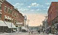
Main Street in 1921
-
General view around 1905
-
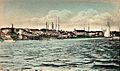
Shipyards in 1905
-
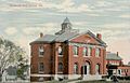
City Hall in 1914
-
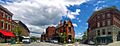
Panoramic view from Post Office Square in 2014
-
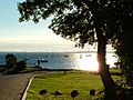
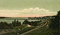
Belfast Bay
-
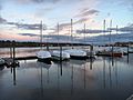
Shipyard on Belfast Bay
-
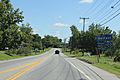
Sign on Maine 3


Geography and Climate
Where is Belfast?
Belfast is located at about 44.42 degrees North and 69.01 degrees West.
The city covers about 38.37 square miles (99.37 square kilometers). Most of this is land (34.04 sq mi or 88.19 sq km). The rest is water (4.33 sq mi or 11.18 sq km). Belfast is on Belfast Bay and Penobscot Bay. The Passagassawakeag River flows through it. Other smaller rivers include Goose River and Little River.
Belfast shares borders with several towns:
- To the north: Waldo and Swanville
- To the east: Searsport
- To the south: Northport
- To the southwest: Belmont
- To the west: Morrill
You can reach Belfast using US Route 1 and several Maine State Routes. These include SR 3, SR 7, SR 52, SR 137, and SR 141.
Belfast's Climate
Belfast has a climate with big changes in temperature throughout the year. Summers are usually hot and humid. Winters are cold and dry. This type of weather is called a humid continental climate.
Population of Belfast
| Historical population | |||
|---|---|---|---|
| Census | Pop. | %± | |
| 1790 | 245 | — | |
| 1800 | 674 | 175.1% | |
| 1810 | 1,274 | 89.0% | |
| 1820 | 2,026 | 59.0% | |
| 1830 | 3,077 | 51.9% | |
| 1840 | 4,186 | 36.0% | |
| 1850 | 5,051 | 20.7% | |
| 1860 | 5,520 | 9.3% | |
| 1870 | 5,278 | −4.4% | |
| 1880 | 5,308 | 0.6% | |
| 1890 | 5,294 | −0.3% | |
| 1900 | 4,615 | −12.8% | |
| 1910 | 4,618 | 0.1% | |
| 1920 | 5,083 | 10.1% | |
| 1930 | 4,993 | −1.8% | |
| 1940 | 5,540 | 11.0% | |
| 1950 | 5,960 | 7.6% | |
| 1960 | 6,140 | 3.0% | |
| 1970 | 5,957 | −3.0% | |
| 1980 | 6,243 | 4.8% | |
| 1990 | 6,355 | 1.8% | |
| 2000 | 6,381 | 0.4% | |
| 2010 | 6,668 | 4.5% | |
| 2020 | 6,938 | 4.0% | |
| U.S. Decennial Census | |||

In 2010, there were 6,668 people living in Belfast. The city had about 196 people per square mile. Most of the people living in Belfast were White (96.7%). About 19.9% of the residents were under 18 years old. The average age in the city was 46.9 years.
Education in Belfast
School Spirit
- Mascot: Belfast Lions
- Colors: Royal Blue and Gold
Schools in Belfast
Belfast is part of Regional School Unit #71 (RSU #71). This school district includes Belfast and nearby towns.
Here are some of the schools in the Belfast area:
- Captain Albert Stevens Elementary School (Grades K–5, in Belfast)
- Troy A. Howard Middle School (Grades 6–8, in Belfast)
- Belfast Area High School (Grades 9–12, in Belfast)
Other elementary schools in RSU #71 are located in nearby towns:
- Ames School (Grades 3–5, in Searsmont)
- Weymouth School (Grades K–2, in Morrill)
- Drinkwater School (Grades K–5, in Northport)
- Nickerson School (Grades K–5, in Swanville)
- East Belfast School (Grades K–5, in East Belfast)
RSU #71 includes the towns of Belfast, Belmont, Swanville, Searsmont, and Morrill.
Fun Places to Visit
Here are some interesting places in Belfast:
- Belfast Historical Society & Museum
- Belfast Free Library, a public library started in 1887
- Front Street Shipyard
- Perry's Nut House
Belfast City Park
Belfast City Park is a large park in the city. It covers about 17.5 acres of land. From the park, you can see beautiful views of Penobscot Bay. Many people use the park in the spring, summer, and fall. It closes during the winter. The park was started in 1904 by a local women's group called the Belfast Village Improvement Society. It was a very big achievement for them!
Famous People from Belfast


Many notable people have connections to Belfast, including:
- Nehemiah Abbott, a U.S. Congressman and mayor
- Hugh J. Anderson, a U.S. Congressman and former governor of Maine
- Dorothy Cannell, a novelist who writes mystery books
- William G. Crosby, a poet and former governor of Maine
- Jonathan Frakes, an actor (used to live here)
- Genie Francis, an actress (used to live here)
- William Veazie Pratt, an admiral and Chief of Naval Operations (the Navy's highest rank)
- Phineas Quimby, known for his work with mesmerism
- Dudley Allen Sargent, a Harvard professor and a pioneer in physical fitness
- Albert William Stevens, an Army officer, balloonist, and photographer. He took the first photos showing the Earth's curve!
- Neil Welliver, an artist who passed away in Belfast
See also
 In Spanish: Belfast (Maine) para niños
