
Northport, Maine facts for kids
Quick facts for kids
Northport, Maine
|
|
|---|---|
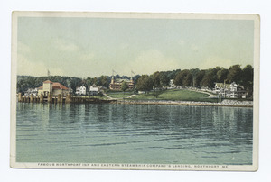
Postcard, early 20th century
|
|

Location of Northport (in yellow) in Waldo County and the state of Maine
|
|
| Country | United States |
| State | Maine |
| County | Waldo |
| Established | 1849 |
| Area | |
| • Total | 34.99 sq mi (90.62 km2) |
| • Land | 23.78 sq mi (61.59 km2) |
| • Water | 11.21 sq mi (29.03 km2) |
| Elevation | 420 ft (128 m) |
| Population
(2020)
|
|
| • Total | 1,550 |
| • Density | 65/sq mi (25.2/km2) |
| Time zone | UTC-5 (Eastern (EST)) |
| • Summer (DST) | UTC-4 (EDT) |
| ZIP code |
04849
|
| Area code(s) | 207 |
| FIPS code | 23-52845 |
| GNIS feature ID | 0582636 |
Northport is a charming town located in Waldo County, Maine. It sits right on the beautiful Penobscot Bay. In 2020, about 1,550 people called Northport home.
One of Northport's special areas is Bayside. This coastal neighborhood is famous for its many old-fashioned Victorian houses. It also has a busy marina for boats and the historic Cobe Estate.
Contents
Exploring Northport's Geography
Northport covers about 35 square miles (90 square kilometers). A big part of this area, about 11 square miles (29 square kilometers), is water. The town has several important bodies of water. These include Pitcher Pond, Knight Pond, and Belfast Reservoir #1.
You can reach Northport using U.S. Route 1 and Maine State Route 52. The town shares its borders with Belfast to the north and Belmont to the west. To the south, you'll find Lincolnville. The stunning Penobscot Bay forms Northport's eastern border.
Northport's Population Over Time
Northport has seen its population grow and change over many years. Here's a quick look at how many people have lived here:
| Historical population | |||
|---|---|---|---|
| Census | Pop. | %± | |
| 1800 | 482 | — | |
| 1810 | 780 | 61.8% | |
| 1820 | 939 | 20.4% | |
| 1830 | 1,083 | 15.3% | |
| 1840 | 1,207 | 11.4% | |
| 1850 | 1,260 | 4.4% | |
| 1860 | 1,178 | −6.5% | |
| 1870 | 902 | −23.4% | |
| 1880 | 872 | −3.3% | |
| 1890 | 691 | −20.8% | |
| 1900 | 545 | −21.1% | |
| 1910 | 518 | −5.0% | |
| 1920 | 466 | −10.0% | |
| 1930 | 413 | −11.4% | |
| 1940 | 485 | 17.4% | |
| 1950 | 574 | 18.4% | |
| 1960 | 658 | 14.6% | |
| 1970 | 755 | 14.7% | |
| 1980 | 958 | 26.9% | |
| 1990 | 1,201 | 25.4% | |
| 2000 | 1,331 | 10.8% | |
| 2010 | 1,520 | 14.2% | |
| 2020 | 1,550 | 2.0% | |
| U.S. Decennial Census | |||
A Closer Look at the 2010 Census
In 2010, about 1,520 people lived in Northport. There were 681 households, which are groups of people living together. Most residents, about 98%, were White. A small number of people were from other racial backgrounds. About 0.7% of the population identified as Hispanic or Latino.
Many households, about 50.7%, were married couples living together. About 25.1% of households had children under 18. The average age in Northport was 47.8 years old. This means many adults and older people live in the town.
Discovering Bayside Village
Bayside is a special part of Northport right on the coast. The Bayside Historic District is famous for its more than one hundred Victorian-style cottages. It also features a marina and the historic Cobe Estate.
The village has narrow roads that branch off two main streets. Bayside Road leaves U.S. Route 1 and then splits. Shore Road is closer to the coast, and Bluff Road is a bit more inland. These roads meet again near Saturday Cove. Main Street runs through the village, connecting the marina and Bluff Road.
Near the village's marina, you'll find Park Row. This street has a line of Victorian houses that look a bit like the famous "Painted Ladies" in San Francisco. These houses are next to Ruggles Park. The old Northport Inn used to stand at the top of Ruggles Park, but it unfortunately burned down in 1919.
-
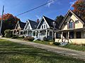
Four of the eleven Victorian cottages lining Park Row
-

Bayside Store on Route 1


