
Stockton Springs, Maine facts for kids
Quick facts for kids
Stockton Springs, Maine
|
|
|---|---|

|
|

Location of Stockton Springs (in yellow) in Waldo County and the state of Maine
|
|
| Country | United States |
| State | Maine |
| County | Waldo |
| Incorporated | 1857 |
| Area | |
| • Total | 29.83 sq mi (77.26 km2) |
| • Land | 19.64 sq mi (50.87 km2) |
| • Water | 10.19 sq mi (26.39 km2) |
| Elevation | 89 ft (27 m) |
| Population
(2020)
|
|
| • Total | 1,533 |
| • Density | 78/sq mi (30.1/km2) |
| Time zone | UTC−5 (Eastern (EST)) |
| • Summer (DST) | UTC−4 (EDT) |
| ZIP Code |
04981
|
| Area code(s) | 207 |
| FIPS code | 23-74475 |
| GNIS feature ID | 0582749 |
Stockton Springs is a small town located in Waldo County, Maine, in the United States. In 2020, about 1,533 people lived there. This town is special because it's home to Fort Point State Park and the historic Fort Point Light. Both of these cool places are found on Fort Point, which is a piece of land sticking out into the water on Cape Jellison.
Contents
History of Stockton Springs
Early Settlement and Fort Pownall
Stockton Springs was first settled around 1759. This was the same year that Governor Thomas Pownall finished building Fort Pownall. The fort was built on Fort Point to protect the mouth of the Penobscot River during the French and Indian War. This war was a big conflict between Great Britain and France, with their allies, over land in North America.
Later, during the American Revolutionary War, the British themselves burned Fort Pownall. They did this in 1775 and again in 1779. Their goal was to stop the fort from being taken over by the American forces.
Becoming a Town
The area that is now Stockton Springs was first made part of a town called Prospect on February 29, 1794. But then, on March 13, 1857, it became its own separate town. It was named Stockton, after a port city in England.
In 1859, Stockton was a busy place with many businesses. There were four sawmills for cutting wood, three shingle mills, and two mills for making lath (thin strips of wood). People also worked at a place that prepared cloth, a tannery for making leather, and four shipyards where ships were built. There were also six blacksmith shops and other mechanic shops.
By 1886, even more businesses had opened. These included a shoe factory, a cheese factory, and a factory that made doors, sashes (window frames), and blinds. There were also people who made casks and barrels, and a clothing factory.
Name Change and Bottled Water Plan
On February 5, 1889, the town's name was changed to Stockton Springs. This was because people hoped to bottle and sell local spring water. However, they found sediment (small bits of dirt) in the bottles. Because of this, the plan to sell the spring water was stopped.
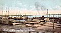
Cape Jellison Port
Cape Jellison became a very busy port. Between 1905 and 1907, three huge wooden piers were built. The longest one was about 1,750 feet (533 meters) long! The Bangor & Aroostook Railroad used these docks to move goods. A very large warehouse was built to hold potatoes from Aroostook County until ships could take them to other places.
Sadly, a big fire on November 8, 1924, destroyed these wharves. This fire marked the end of the harbor's busy industrial time.
Geography of Stockton Springs
Stockton Springs covers a total area of about 29.83 square miles (77.26 square kilometers). About 19.64 square miles (50.87 square kilometers) of this is land, and 10.19 square miles (26.39 square kilometers) is water. The town is located right on Penobscot Bay, which is part of the Gulf of Maine in the Atlantic Ocean. This means it has a beautiful coastline.
Important roads that go through Stockton Springs include U.S. Route 1, U.S. Route 1A, and Maine State Route 3.
Population Information
| Historical population | |||
|---|---|---|---|
| Census | Pop. | %± | |
| 1860 | 1,595 | — | |
| 1870 | 2,089 | 31.0% | |
| 1880 | 1,548 | −25.9% | |
| 1890 | 1,149 | −25.8% | |
| 1900 | 872 | −24.1% | |
| 1910 | 1,103 | 26.5% | |
| 1920 | 1,175 | 6.5% | |
| 1930 | 877 | −25.4% | |
| 1940 | 905 | 3.2% | |
| 1950 | 949 | 4.9% | |
| 1960 | 980 | 3.3% | |
| 1970 | 1,142 | 16.5% | |
| 1980 | 1,230 | 7.7% | |
| 1990 | 1,385 | 12.6% | |
| 2000 | 1,481 | 6.9% | |
| 2010 | 1,591 | 7.4% | |
| 2020 | 1,533 | −3.6% | |
| U.S. Decennial Census | |||
Population in 2010
In 2010, there were 1,591 people living in Stockton Springs. There were 694 households, which are groups of people living together in one home. The average household had about 2.29 people.
The average age of people in the town was about 49.9 years old. About 17.3% of the residents were under 18 years old. About 20.4% of the people were 65 years old or older.
Places to Visit
Images for kids
-

Cape Jellison around 1908
-
Long Pier around 1908
-
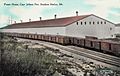
Potato warehouse in 1910


See also
 In Spanish: Stockton Springs para niños
