
Fort Point Light (Maine) facts for kids
 |
|
| Fort Point Light in September, 2005. | |

Fort Point Light
Location in Maine
|
|
| Location | Penobscot River Entrance |
|---|---|
| Coordinates | 44°28′1.682″N 68°48′42.058″W / 44.46713389°N 68.81168278°W |
| Year first constructed | 1836 |
| Year first lit | 1857 (current structure) |
| Automated | 1988 |
| Tower shape | Square Brick Tower |
| Markings / pattern | White |
| Focal height | 88 feet (27 m) |
| Original lens | 4th order Fresnel Lens |
| Current lens | Original |
| Range | 15 nautical miles (28 km; 17 mi) |
| Characteristic | F W |
| Fog signal | HORN: 1 every 10s |
| USCG number | 1-3580 |
The Fort Point Light is a historic lighthouse in Stockton Springs, Maine. It is also known as the Fort Point Light Station. This lighthouse helps ships find their way safely. It has been active since 1835. The lighthouse you see today was built in 1857. It is listed on the National Register of Historic Places, which means it's an important historical site.
Contents
Where is Fort Point Light Located?
The Fort Point Light is inside Fort Point State Park. This park is at the very end of Cape Jellison. Cape Jellison is a triangle-shaped piece of land. It sticks out into Penobscot Bay, right where the Penobscot River meets the bay.
The park covers about 120 acres. It was created in 1974. Besides the lighthouse, the park also has the old ruins of Fort Pownall. This fort was built way back in 1757. The lighthouse stands a little southwest of the tip of the land. It is also south of where the old fort used to be.
What Does the Lighthouse Look Like?
The Fort Point Light Station has several buildings. It includes the lighthouse tower itself. This tower is connected to the keeper's house. There is also a barn, an oil house, and a bell house.
The lighthouse tower is made of square bricks. It is about 26 feet tall, measured up to the top lantern. Around the top of the tower is a square railing. The light sits inside an eight-sided lantern house. This lantern house has an eight-sided roof with a round vent on top.
A small brick room connects the tower to the keeper's house. The keeper's house is a two-and-a-half story wooden building. Its main roof runs north to south. The front of the house faces west and has three sections. The main door is on the right side. It is inside a small, covered porch. A single-story part of the house sticks out from the back.
East of the house, there is a small barn. This barn has been there since the 1890s. To the west, you will find a small brick oil house. It has one door and a pointed roof. Further east is the bell house. This building is made of wood and covered in shingles. It has a pyramid shape. The oil house was built in 1897, and the bell house was built in 1890.
History of Fort Point Light
The idea for Fort Point Light Station was approved by Congress in 1834. It was built on land bought from William Clewley. He was the first person to work as the lighthouse keeper. This was the first lighthouse built on a river in Maine. It was needed because more and more ships were using the bay and river.
The tower and keeper's house you see today were built in 1857. They replaced the first lighthouse. The original lamp was changed in 1935. It was then connected to electricity in 1950. In 1988, the lighthouse became automated. This means it runs by itself without a keeper. It still helps guide ships today.
The light uses a special lens called a fourth-order Fresnel lens. This type of lens is very old but still works well. It is one of only eight Fresnel lenses still used in Maine. The first fog signal was a very heavy cast iron bell. It weighed 1200 pounds! Now, a fog horn is used in the same building.
The United States Coast Guard rented the lighthouse to the state of Maine in 1989. Then, in 1998, they sold it to the state.
Images for kids
-
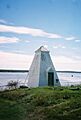
Fog signal tower in September, 2005
-

Fog signal bell


