Fort Pownall facts for kids
Quick facts for kids |
|
|
Fort Pownall Memorial
|
|
 |
|
| Nearest city | Stockton Springs, Maine |
|---|---|
| Area | 3 acres (1.2 ha) |
| Built | May–July 1759 |
| NRHP reference No. | 69000028 |
| Added to NRHP | October 28, 1969 |
Fort Pownall was a British fort built a long time ago during a conflict called the French and Indian War. Today, you can still see its remains at Fort Point State Park in Stockton Springs, Maine. The fort got its name from Governor Thomas Pownall, who was in charge of building it. Interestingly, this fort never saw any battles. It was later destroyed during the American Revolutionary War by both American colonists and the British army to stop anyone else from using it. What's left of the fort was added to the National Register of Historic Places in 1969, which means it's an important historical site.
Contents
Where is Fort Pownall Located?
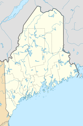
Fort Pownall is found inside Fort Point State Park. This park is at the very eastern tip of Cape Jellison. Cape Jellison is a triangle-shaped piece of land that sticks out into Penobscot Bay, right where the Penobscot River meets the ocean.
The park itself is about 120 acres (49 hectares) big and was created in 1974. Besides the old fort, the park also has the Fort Point Lighthouse. The fort's ruins are on the highest ground near the very end of the cape.
Why Was Fort Pownall Built?
In 1759, during the French and Indian War, the governor of Massachusetts, Thomas Pownall, decided to build this fort. He named it Fort Pownall after himself. This fort was one of three important forts the British built along major rivers in the Northeast. Their goal was to control the waterways and stop attacks on British settlers. Other forts like this included Fort Halifax and Fort Frederick (Saint John, New Brunswick).
The main reason for Fort Pownall was to make the area safe for European settlers. It was meant to push away the remaining Norridgewock and Penobscot Native American groups. The first leader of the fort was Jedidiah Preble, who served from 1759 to 1763. After him, Colonel Thomas Goldthwait was in charge from 1763 to 1775.
What Happened to Fort Pownall?
In 1775, British forces took the cannons and gunpowder from the fort. Later, during the American Revolutionary War, a group of Continental Army soldiers burned down the fort's main building, called a blockhouse. They also filled in most of the ditches around the fort. This was done to make sure the British couldn't use the fort again.
What Did Fort Pownall Look Like?
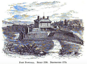
When it was first built, Fort Pownall was roughly 240 feet (73 meters) on each side. It had an eight-sided, star-shaped wall made of earth. Around this earth wall was a moat or ditch that was about 15 feet (4.6 meters) wide and 8 feet (2.4 meters) deep.
Inside these earth walls was a blockhouse. This was a strong building made from large, squared timbers. It measured 44 feet (13 meters) on each side and was two stories tall. At each corner of the blockhouse, there was a diamond-shaped part that stuck out, with each side being 33 feet (10 meters) long.
Because the blockhouse and other wooden parts of the fort were burned down, today you can only see the earth walls and the stone foundations that remain.
 | May Edward Chinn |
 | Rebecca Cole |
 | Alexa Canady |
 | Dorothy Lavinia Brown |


