Stonington, Maine facts for kids
Quick facts for kids
Stonington, Maine
|
|
|---|---|

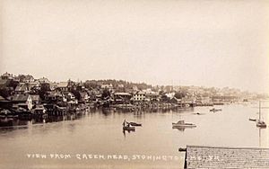
View of the waterfront c. 1915
|
|
| Country | United States |
| State | Maine |
| County | Hancock |
| Incorporated | 1897 |
| Area | |
| • Total | 37.84 sq mi (98.01 km2) |
| • Land | 9.81 sq mi (25.41 km2) |
| • Water | 28.03 sq mi (72.60 km2) |
| Elevation | 20 ft (6 m) |
| Population
(2020)
|
|
| • Total | 1,056 |
| • Density | 108/sq mi (41.6/km2) |
| Time zone | UTC−5 (Eastern (EST)) |
| • Summer (DST) | UTC−4 (EDT) |
| ZIP Code |
04681
|
| Area code(s) | 207 |
| FIPS code | 23-74580 |
| GNIS feature ID | 0582751 |
Stonington is a town in Hancock County, Maine, United States. It is located on the southern part of Deer Isle. In 2020, 1,056 people lived there. The town includes small areas like Burnt Cove, Oceanville, Green Head, and Clam City.
Stonington is known for its beautiful waterfront and as a popular place for tourists. It is also one of the top places in the country for catching lobsters. In fact, it is the biggest lobster fishing port in Maine. In 2011, fishermen from Stonington caught over 14.8 million pounds of lobster. This was worth about $46.3 million!
Contents
History of Stonington
The first people to live on Deer Isle were Native Americans. They arrived as early as 6,100 years ago. Later, French explorers called their descendants the Etchemins. Some Native Americans still lived on the island even after European settlers arrived.
Early European Explorers and Settlers
The first European to explore this area was Estevan Gomez. He was a Portuguese sailor working for Spain. He sailed his ship, La Anunciada, through Eggemoggin Reach. This waterway separates Deer Isle from the mainland.
The French were very active in this region. They built a fort in Castine and married people from the local Abenaki tribes. A body wearing full armor was found on nearby Campbell Island. People believe it belonged to a French person.
Life on Deer Isle: From Farming to Fishing
Around 1760, New England colonists started settling Deer Isle. Some of these settlers were descendants of George Gray. He was a Scottish soldier captured in a battle in 1650 and sent to America. His grandchildren, Joshua and Andrew, helped settle the area.
At first, these settlers wanted to farm the land. They built farms and cabins on the northern part of Deer Island. The southern part, which is now Stonington, was settled after 1800. It was first known as Green's Landing.
Over time, the soil became tired from too much farming. Also, many trees were cut down. So, the people of Deer Isle turned to the sea. They became skilled at building ships, sailing, and fishing.
The Granite Boom and Stonington's Growth
Green's Landing was a small fishing village for a long time. It didn't change much until after 1870. This is when the "granite boom" began. Quarrying, which means digging out stone, became a very important job.
The stone from Stonington was used to build important buildings across the country. For example, the Museum of Fine Arts in Boston used Stonington granite. Many stonecutters came from Europe, especially Italy, to work here.
Some workers lived in special buildings called barracks on Crotch Island. Others stayed in hotels and large boarding houses. Today, many of these old buildings have been turned into restaurants, art galleries, and shops.
Becoming the Town of Stonington
On February 18, 1897, Green's Landing officially became the town of Stonington. The Maine State Legislature made it a town. It was named Stonington because of its famous granite quarries.
To the west of the main harbor is Steamboat Wharf. Today, the Isle au Haut Boat Company uses it. Before that, it was a factory that canned sardines.
Before the Deer Isle-Sedgwick Bridge connected the island to the mainland in 1939, Steamboat Wharf was very important. Steamboats arrived daily from places like Rockland. They brought goods and people from as far away as Boston.
The harbor has always been full of Friendship Sloops. These are boats powered only by sails. Lobstermen used them to pull up their lobster traps. They would often fish near outer islands and return to the harbor on weekends. This changed when boats started using gasoline or diesel engines. New boat designs also allowed fishermen to make shorter, daily trips to fishing spots in Penobscot Bay.
Geography of Stonington
Stonington is located on the southern end of Deer Isle. It is part of Penobscot Bay and the Gulf of Maine. These are both parts of the Atlantic Ocean.
The town covers about 37.8 square miles (98.0 square kilometers) in total. About 9.8 square miles (25.4 square kilometers) of this is land. The rest, about 28.0 square miles (72.6 square kilometers), is water.
Maine State Route 15 ends in Stonington. This road goes through the town of Deer Isle. It then crosses the Deer Isle Bridge to connect to the mainland.
Population in Stonington
| Historical population | |||
|---|---|---|---|
| Census | Pop. | %± | |
| 1900 | 1,648 | — | |
| 1910 | 2,038 | 23.7% | |
| 1920 | 1,353 | −33.6% | |
| 1930 | 1,418 | 4.8% | |
| 1940 | 1,493 | 5.3% | |
| 1950 | 1,660 | 11.2% | |
| 1960 | 1,408 | −15.2% | |
| 1970 | 1,291 | −8.3% | |
| 1980 | 1,273 | −1.4% | |
| 1990 | 1,252 | −1.6% | |
| 2000 | 1,152 | −8.0% | |
| 2010 | 1,043 | −9.5% | |
| 2020 | 1,056 | 1.2% | |
| U.S. Decennial Census | |||
Stonington's Population in 2010
In 2010, there were 1,043 people living in Stonington. These people lived in 515 households. About 305 of these were families.
Most people in Stonington were White (97.0%). A small number were from other racial backgrounds. About 14.8% of the people were under 18 years old. About 23.4% were 65 years old or older. The average age in town was 50.7 years.
There were slightly more females (50.3%) than males (49.7%) in Stonington.
See also
 In Spanish: Stonington (Maine) para niños
 | Tommie Smith |
 | Simone Manuel |
 | Shani Davis |
 | Simone Biles |
 | Alice Coachman |


