Verona Island, Maine facts for kids
Quick facts for kids
Verona Island, Maine
|
|
|---|---|

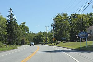
Sign for Verona Island on US1
|
|
| Country | United States |
| State | Maine |
| County | Hancock |
| Villages | Verona Verona Park |
| Area | |
| • Total | 8.77 sq mi (22.71 km2) |
| • Land | 6.24 sq mi (16.16 km2) |
| • Water | 2.53 sq mi (6.55 km2) |
| Population
(2020)
|
|
| • Total | 507 |
| • Density | 81/sq mi (31.4/km2) |
| Time zone | UTC-5 (Eastern (EST)) |
| • Summer (DST) | UTC-4 (EDT) |
| ZIP Code |
04416
|
| Area code(s) | 207 |
Verona Island is a small town in Maine, United States. It is located on an island with the same name. This island is found in the Penobscot River. In 2020, about 507 people lived there. It is part of Hancock County.
Contents
A Look at Verona Island's Past
The island and its community have had many different names over time.
Early Names of the Island
- It was first called Penobscot Island.
- Later, it became known as Orphan Island. This happened when Henry Knox gave it to his grandchildren who had lost their parents.
- In 1839, it was called the plantation of Wetmore Isle.
- On February 18, 1861, it officially became a town. Its name was changed to Verona, after the city of Verona, Italy.
- On March 27, 2004, the town voted to change its name again. It became Verona Island, matching the name of the land it sits on.
Shipbuilding History
Verona Island was once a busy place for building ships. Many years ago, people here built large vessels. The last ship built on the island was in 1905. This ship was called the Roosevelt. It was a special ship because it carried Robert Peary to the Arctic in 1908. He used it for his final trip to the North Pole.
Important Bridges
Two important bridges have connected Verona Island to the mainland.
The Old Waldo-Hancock Bridge
The Waldo–Hancock Bridge opened on November 16, 1931. It connected Verona Island to Prospect in Waldo County. This bridge carried U.S. 1. It was listed on the National Register of Historic Places. However, the bridge became very old and unsafe. So, a new bridge had to be built. The old bridge started to be taken down on November 20, 2012.
The New Penobscot Narrows Bridge
The new bridge is called the Penobscot Narrows Bridge and Observatory. It opened on December 30, 2006. At first, lawmakers wanted to name it the Downeast Gateway Bridge. But many people in the area did not like that name. So, they changed it. On March 9, 2006, everyone agreed on the new name. This bridge is a modern and important link for the area.
Geography of Verona Island
Verona Island is not very big. It covers about 8.77 square miles (22.71 square kilometers). Most of this area is land, about 6.24 square miles (16.16 square kilometers). The rest is water, about 2.53 square miles (6.55 square kilometers).
The highest spot on the island is McCloud Mountain. It is about 344 feet (105 meters) above the sea.
Population Over Time
The number of people living on Verona Island has changed over the years. Here is a quick look at the population from different years:
- 1840: 139 people
- 1850: 405 people
- 1860: 399 people
- 1870: 352 people
- 1880: 356 people
- 1900: 234 people
- 1910: 229 people
- 1920: 233 people
- 1930: 228 people
- 1940: 391 people
- 1950: 374 people
- 1960: 435 people
- 1970: 437 people
- 1980: 559 people
- 1990: 515 people
- 2000: 533 people
- 2010: 544 people
- 2020: 507 people
See also
 In Spanish: Verona Island para niños
 | Tommie Smith |
 | Simone Manuel |
 | Shani Davis |
 | Simone Biles |
 | Alice Coachman |


