
Bucksport, Maine facts for kids
Quick facts for kids
Bucksport, Maine
|
|
|---|---|

Bucksport from Fort Knox, 2004
|
|

Bucksport, Maine
Location in Maine

Bucksport, Maine
Location in the United States
|
|
| Country | United States |
| State | Maine |
| County | Hancock |
| Incorporated | 1792 |
| Villages | Bucksport Bucksport Center East Bucksport Millvale North Bucksport |
| Area | |
| • Total | 56.53 sq mi (146.41 km2) |
| • Land | 51.54 sq mi (133.49 km2) |
| • Water | 4.99 sq mi (12.92 km2) |
| Population
(2020)
|
|
| • Total | 4,944 |
| • Density | 96/sq mi (37.0/km2) |
| Time zone | UTC-5 (Eastern (EST)) |
| • Summer (DST) | UTC-4 (EDT) |
| ZIP code |
04416
|
| Area code(s) | 207 |
| Website | Town website |
Bucksport is a cool, old town in Hancock County, Maine, United States. It's a town with a lot of history. In 2020, about 4,944 people lived there. Bucksport is located right across the Penobscot River from Fort Knox. You can also see the amazing Penobscot Narrows Bridge from Bucksport.
Contents
History of Bucksport
Early People and First Settlers
The very first people in Bucksport lived there about 5,000 years ago. They were part of a prehistoric group called the Red Paint People. They were known for burying red paint with their tools and weapons. Scientists think they were skilled fishers. The first archaeological dig in Maine happened here in 1891. It was on Indian Point, where a paper mill is now.
Later, the land belonged to the Penobscot Native Americans. In 1762, Colonel Jonathan Buck came to explore the area. He returned in 1763 to settle permanently. He built a sawmill and a house. By 1775, about 21 families lived in the area.
Revolutionary War and Town Names
During the Revolutionary War, British soldiers built Fort George nearby. In 1779, the British burned most of Bucksport. They spared only those who promised loyalty to the British king. After the war ended in 1783, people moved back. The town was first called Buckstown Plantation, after Colonel Buck. It officially became Buckstown in 1792 and was renamed Bucksport in 1817. The British also occupied the town during the War of 1812.
Old Buildings and Fun Stories
The Jed Prouty Tavern and Inn was built in 1780 in downtown Bucksport. It became a big hotel with 17 rooms around 1820. Today, it's being turned into a nursing home for older people.
Bucksport is also known for some wild stories! In 1892, a circus elephant named Charlie escaped. He roamed the town freely for a while. A brave pit bull helped to corner the elephant so his handlers could catch him.
Bucksport was even featured in a 1960s TV show called Dark Shadows. The show used Bucksport as inspiration for its fictional town, Collinsport.
Old Industries and the Paper Mill
The land in Bucksport has many ponds and streams. In the past, farmers grew hay and potatoes. But shipbuilding became the main job. Many people also worked in fishing, sailing to the Grand Banks to catch fish. Other businesses made lumber, parts for ships, barrels, and carriages.
In 1874, the Bucksport and Bangor Railroad was finished. This helped Bangor ship goods during winter when the river froze.
The Maine Seaboard Paper Company opened the Bucksport Mill in 1930. This paper mill made a lot of newsprint paper every day. Later, it was owned by Verso Paper. The mill made special lightweight paper used in magazines like Time Magazine. Sadly, the mill closed in 2014, and many people lost their jobs.
Geography of Bucksport
Bucksport covers about 56.53 square miles. Most of this is land, and about 4.99 square miles is water. The town is at the top of Penobscot Bay. The Penobscot River flows through it. Bucksport also has Silver Lake, which is a great spot for fishing and birdwatching.
Important roads like U. S. Route 1 and state routes 3, 15, and 46 pass through the town. Bucksport shares borders with several other towns. These include Orrington, Holden, Dedham, Orland, Verona, Prospect, Frankfort, and Winterport.

Population of Bucksport
Bucksport has grown over the years. Here's how its population has changed:
| Historical population | |||
|---|---|---|---|
| Census | Pop. | %± | |
| 1800 | 624 | — | |
| 1810 | 1,403 | 124.8% | |
| 1820 | 1,658 | 18.2% | |
| 1830 | 2,237 | 34.9% | |
| 1840 | 3,015 | 34.8% | |
| 1850 | 3,381 | 12.1% | |
| 1860 | 3,554 | 5.1% | |
| 1870 | 3,433 | −3.4% | |
| 1880 | 3,047 | −11.2% | |
| 1890 | 2,921 | −4.1% | |
| 1900 | 2,339 | −19.9% | |
| 1910 | 2,216 | −5.3% | |
| 1920 | 1,906 | −14.0% | |
| 1930 | 2,135 | 12.0% | |
| 1940 | 2,927 | 37.1% | |
| 1950 | 3,102 | 6.0% | |
| 1960 | 3,466 | 11.7% | |
| 1970 | 3,756 | 8.4% | |
| 1980 | 4,345 | 15.7% | |
| 1990 | 4,825 | 11.0% | |
| 2000 | 4,908 | 1.7% | |
| 2010 | 4,924 | 0.3% | |
| 2020 | 4,944 | 0.4% | |
| U.S. Decennial Census | |||
Places to Visit in Bucksport
- Alamo Theatre – Northeast Historic Film
- Bucksport High School
- Bucksport Railroad Station (now the Bucksport Historical Society Museum)
- The Alamo Theater and Northeast Historic Film study center and film archive
Famous People from Bucksport
- Carl Darling Buck, a language expert
- Dustin Farnum, actor
- William Farnum, actor
- Frank Fellows, a US congressman
- Edward Winslow Hinks, a general from the Civil War
- Molly Kool, America's first registered female ship captain
- Kimberley Rosen, a state representative
- Richard Rosen, a state senator
- Edward Vernon Sparhawk, writer and newspaper editor
- William Pierce Stubbs, artist
- Dora Wiley, singer
Images for kids
-
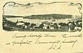
Bucksport Harbor in 1905
-
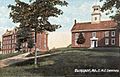
E. M. C. Seminary around 1907
-
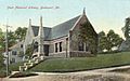
Buck Memorial Library around 1908
-

Bucksport Bank around 1910


See also
 In Spanish: Bucksport (Maine) para niños
