
Phillips, Maine facts for kids
Quick facts for kids
Phillips, Maine
|
|
|---|---|

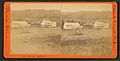
Main Street in 1907
|
|

Phillips, Maine
Location in Maine
|
|
| Country | United States |
| State | Maine |
| County | Franklin |
| Incorporated | 1812 |
| Area | |
| • Total | 50.99 sq mi (132.06 km2) |
| • Land | 50.81 sq mi (131.60 km2) |
| • Water | 0.18 sq mi (0.47 km2) |
| Elevation | 1,171 ft (357 m) |
| Population
(2020)
|
|
| • Total | 898 |
| • Density | 18/sq mi (6.8/km2) |
| Time zone | UTC-5 (Eastern (EST)) |
| • Summer (DST) | UTC-4 (EDT) |
| ZIP code |
04966
|
| Area code(s) | 207 |
| FIPS code | 23-58445 |
| GNIS feature ID | 0582674 |
Phillips is a small town in Franklin County, Maine, in the United States. In 2020, about 898 people lived there. It is famous for the Sandy River and Rangeley Lakes Railroad, which is a special old train line.
Contents
History of Phillips
The land where Phillips is located was given by Massachusetts around 1790. It was given to Jonathan Phillips from Boston. The first person to settle here was Perkins Allen in 1791. He was a sea captain from Martha's Vineyard and called the area Curvo.
The town officially became Phillips on February 25, 1812. It was named after Jonathan Phillips. The town was known for its good soil, where hay was the main crop. It also had strong water power from the Sandy River. This power helped run many early factories.
At the falls along the Sandy River, people built sawmills to cut wood. They also had gristmills to grind grain. Other factories included a fulling mill and a carding machine for making cloth.
Many other businesses grew in Phillips. There was a factory that made starch and a tannery for leather. People also made furniture, boots, and shoes. There were even shops for making carriages and harnesses.
Phillips became very important for lumbering in the Rangeley Lake area. At first, cut wood was moved on sledges pulled by oxen during winter. Then, in 1879, the narrow-gauge Sandy River Railroad opened. This train line connected Phillips to Farmington. From there, the Maine Central Railroad took goods to other places.
In 1891, the railroad became the Sandy River and Rangeley Lakes Railroad. The railroad stopped running in 1935. However, a small part of it has been rebuilt. Today, it is a fun tourist attraction and museum.
Geography of Phillips
Phillips covers about 50.99 square miles (132.06 square kilometers). Most of this area is land, with a small part being water. The town gets its water from the Sandy River. This river flows into the larger Kennebec River.
Phillips is surrounded by other towns and townships. To the north are Madrid and Salem Townships. To the west is Township 6 North of Weld. Weld and Avon are to the south. Freeman Township is to the east.
You can reach Phillips by state routes 4, 142, and 149.
Toothaker Pond
| Toothaker Pond | |
|---|---|
|
Toothaker Pond
Location in Maine
|
|
| Coordinates | 44°52′N 70°24′W / 44.867°N 70.400°W |
| Primary outflows | Sandy River |
| Max. length | 500 yd (460 m) |
| Surface area | 23 acres (9.3 ha) |
| Max. depth | 20 feet (6.1 m) |
| Water volume | 134 acre⋅ft (165,000 m3) |
| Surface elevation | 794 ft (242 m) |
Toothaker Pond is in the northern part of Phillips. The Sandy River and Rangeley Lakes Railroad used to follow the west side of this pond. The pond flows into the Sandy River about 1 mile (1.6 km) south.
In 1902, the Berlin Mills Co. built a sawmill here. They used Toothaker Pond to hold logs. After the sawmill closed in 1908, people built homes and cabins around the pond.
Sometimes, the pond has too much algae in the summer. It also has low oxygen levels. Fish found in the pond include Brook Trout, rainbow smelt, golden shiner, Yellow Perch, and redbelly dace.
Population of Phillips
| Historical population | |||
|---|---|---|---|
| Census | Pop. | %± | |
| 1820 | 634 | — | |
| 1830 | 954 | 50.5% | |
| 1840 | 1,312 | 37.5% | |
| 1850 | 1,673 | 27.5% | |
| 1860 | 1,698 | 1.5% | |
| 1870 | 1,373 | −19.1% | |
| 1880 | 1,437 | 4.7% | |
| 1890 | 1,394 | −3.0% | |
| 1900 | 1,399 | 0.4% | |
| 1910 | 1,423 | 1.7% | |
| 1920 | 1,353 | −4.9% | |
| 1930 | 1,143 | −15.5% | |
| 1940 | 1,186 | 3.8% | |
| 1950 | 1,088 | −8.3% | |
| 1960 | 1,021 | −6.2% | |
| 1970 | 979 | −4.1% | |
| 1980 | 1,092 | 11.5% | |
| 1990 | 1,148 | 5.1% | |
| 2000 | 990 | −13.8% | |
| 2010 | 1,028 | 3.8% | |
| 2020 | 898 | −12.6% | |
| U.S. Decennial Census | |||
Phillips in 2010
In 2010, there were 1,028 people living in Phillips. They lived in 454 households, and 284 of these were families. The town had about 20 people per square mile (7.8 per square kilometer). There were 668 housing units in total.
Most people in Phillips were White (97.7%). About 1.1% of the population was Hispanic or Latino.
About 26.4% of households had children under 18 living with them. Nearly half (47.8%) were married couples. About 30.6% of households were single people living alone. The average age in town was 45.5 years old. About 21.7% of residents were under 18.
Schools in Phillips
Phillips is part of Maine School Administrative District 58. The town is home to Phillips Elementary School.
Old Photos of Phillips
-
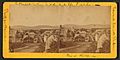
General view c. 1872–1873
-
Barden House
-
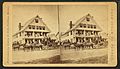
Kimball's Hotel


Places to Visit in Phillips
- Daggett Rock – This is Maine's largest glacial erratic, a huge rock moved by a glacier.
- Phillips Historical Society – Learn about the town's past.
- Sandy River and Rangeley Lakes Railroad – Visit the museum and ride the historic train.
Famous People from Phillips
- Horace A. Barrows – A doctor in the 1800s who made plant-based medicines.
- Carroll L. Beedy – A US congressman.
- Nathan Cook Brackett – An abolitionist who helped start Storer College and Bluefield State College.
- Minnie D. Craig – A legislator.
- J. Blaine Morrison – A lawyer and legislator in Maine.
- Andrew Bonney Robbins – An entrepreneur and Civil War veteran.
- Norman Harry Rothschild – A professor who studied ancient China.
- John P. Soule – A photographer and publisher.
- C. J. Stevens – A writer.
- Augustus Stinchfield – A physician.
Climate in Phillips
Phillips has a type of weather called a humid continental climate. This means there are big differences in temperature throughout the year. Summers are warm to hot and often humid. Winters are cold, sometimes very cold.
See also
 In Spanish: Phillips (Maine) para niños
