Oxford County, Maine facts for kids
Quick facts for kids
Oxford County
|
|
|---|---|
|
|
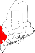
Location within the U.S. state of Maine
|
|
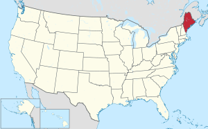 Maine's location within the U.S. |
|
| Country | |
| State | |
| Founded | 1805 |
| Named for | Oxford, Massachusetts |
| Seat | Paris |
| Largest town | Rumford |
| Area | |
| • Total | 2,176 sq mi (5,640 km2) |
| • Land | 2,077 sq mi (5,380 km2) |
| • Water | 99 sq mi (260 km2) 4.5%% |
| Population
(2020)
|
|
| • Total | 57,777 |
| • Estimate
(2021)
|
58,629 |
| • Density | 26.552/sq mi (10.2518/km2) |
| Time zone | UTC−5 (Eastern) |
| • Summer (DST) | UTC−4 (EDT) |
| Congressional district | 2nd |
Oxford County is a special area in the state of Maine, United States. It is like a large district with its own local government. In 2020, about 57,777 people lived here. The main town where the county government is located is called Paris.
Oxford County was created a long time ago, on March 4, 1805. It was formed from parts of York and Cumberland counties. The county is located right next to the country of Canada, specifically the Canadian province of Quebec. Parts of Oxford County are also near bigger cities like Lewiston, Auburn, and Portland.
Contents
Geography of Oxford County
Oxford County is a big place! It covers a total area of about 2,176 square miles. Most of this area, about 2,077 square miles, is land. The rest, about 99 square miles, is water. This means about 4.5% of the county is covered by water.
Neighboring Areas
Oxford County shares its borders with several other counties and a Canadian province:
- Franklin County – to the northeast
- Androscoggin County – to the east
- Cumberland County – to the southeast
- York County – to the south
- Carroll County, New Hampshire – to the southwest (in New Hampshire)
- Coös County, New Hampshire – to the west (in New Hampshire)
- Le Granit Regional County Municipality, Quebec – to the north (in Canada)
Special Protected Lands
Some parts of Oxford County are protected areas, which means they are kept safe for nature and wildlife:
- Umbagog National Wildlife Refuge (a part of it is in Oxford County)
- White Mountain National Forest (a part of it is in Oxford County)
People of Oxford County
| Historical population | |||
|---|---|---|---|
| Census | Pop. | %± | |
| 1810 | 17,630 | — | |
| 1820 | 27,104 | 53.7% | |
| 1830 | 35,219 | 29.9% | |
| 1840 | 38,351 | 8.9% | |
| 1850 | 39,763 | 3.7% | |
| 1860 | 36,698 | −7.7% | |
| 1870 | 33,488 | −8.7% | |
| 1880 | 32,627 | −2.6% | |
| 1890 | 30,586 | −6.3% | |
| 1900 | 32,238 | 5.4% | |
| 1910 | 36,256 | 12.5% | |
| 1920 | 37,700 | 4.0% | |
| 1930 | 41,483 | 10.0% | |
| 1940 | 42,662 | 2.8% | |
| 1950 | 44,221 | 3.7% | |
| 1960 | 44,345 | 0.3% | |
| 1970 | 43,457 | −2.0% | |
| 1980 | 48,968 | 12.7% | |
| 1990 | 52,602 | 7.4% | |
| 2000 | 54,755 | 4.1% | |
| 2010 | 57,833 | 5.6% | |
| 2020 | 57,777 | −0.1% | |
| 2023 (est.) | 59,905 | 3.6% | |
| U.S. Decennial Census 1790–1960 1900–1990 1990–2000 2010–2016 2018 |
|||
Family Backgrounds
Many people in Oxford County have family roots from different parts of the world. In 2015, the largest groups of people reported their family backgrounds as:
| Main Family Backgrounds (2015) | Percentage |
|---|---|
| English |
22.6% |
| French or French Canadian |
20.9% |
| Irish |
15.7% |
| "American" |
8.9% |
| German |
6.5% |
| Scottish |
5.6% |
| Italian |
4.9% |
| Polish |
1.9% |
Fun Things to Do
Oxford County is a popular spot for summer camps! Many kids come here to enjoy the outdoors and make new friends. Some of the well-known camps include:
- Camp Wekeela
- Kamp Kohut
- Camp Wyonegonic
- Forest Acres Camp for Girls
- Maine Teen Camp
Towns and Communities
Oxford County has many towns and smaller communities. Here are some of them:
Towns
Plantations
Plantations are small, rural communities that have a simpler form of local government.
- Lincoln Plantation
- Magalloway (used to be a plantation)
Unorganized Territories
These are areas that don't have their own local government and are managed directly by the county or state.
Census-Designated Places (CDPs)
CDPs are areas that are identified by the U.S. Census Bureau for statistical purposes. They are like towns but don't have their own separate local government.
Other Small Communities
These are even smaller places within the county.
- Center Lovell
- Dickvale
- Magalloway
- North Waterford
- Waterford Flat
- West Bethel, Maine
See also
 In Spanish: Condado de Oxford para niños
 | May Edward Chinn |
 | Rebecca Cole |
 | Alexa Canady |
 | Dorothy Lavinia Brown |


