
Rumford, Maine facts for kids
Quick facts for kids
Rumford, Maine
|
||
|---|---|---|
|
Town
|
||

Congress Street in downtown Rumford
|
||
|
||

Location of Rumford, Maine
|
||
| Country | United States | |
| State | Maine | |
| County | Oxford | |
| Settled | 1782 | |
| Incorporated (town) | February 21, 1800 | |
| Area | ||
| • Total | 69.85 sq mi (180.91 km2) | |
| • Land | 68.55 sq mi (177.54 km2) | |
| • Water | 1.30 sq mi (3.37 km2) | |
| Population
(2020)
|
||
| • Total | 5,858 | |
| • Density | 85/sq mi (33.0/km2) | |
| Time zone | UTC-5 (Eastern (EST)) | |
| • Summer (DST) | UTC-4 (EDT) | |
| ZIP Code |
04276
|
|
| Area code(s) | 207 | |

Rumford is a town located in Oxford County, Maine, United States. It's part of the wider Lewiston-Auburn metropolitan area. In 2020, about 5,858 people lived here. Rumford is known for the ND Paper Inc's Rumford Mill and the Black Mountain of Maine ski resort.
Contents
Discovering Rumford's Past

Rumford was first called New Pennacook Plantation. It was given to Timothy Walker, Jr. and his friends from Concord, New Hampshire in 1779. Many early settlers came from Concord. Both Pennacook and Rumford are old names for Concord. The very first settlers, Jonathan Keyes and his son Francis, arrived in 1782 from Shrewsbury, Massachusetts. The town officially became Rumford in 1800. Later, it added land from nearby Peru and Franklin Plantation.
Rumford is in the foothills of the White Mountains. It's famous for Pennacook Falls, which is a huge waterfall on the Androscoggin River. The river drops about 177 feet (54 meters) over solid granite. Long ago, St. Francis Indians hunted and fished here. Salmon used to lay their eggs in the pool below the Upper Falls. This area was also a place for Indians to trade furs. Early settlers built sawmills and gristmills using the river's power. For its first 100 years, Rumford was mostly a farming community.
The Rise of Paper Mills
In 1882, a businessman named Hugh J. Chisholm saw how powerful the falls were. He realized they could be used to make paper. Chisholm built the Portland and Rumford Falls Railway. This connected Rumford to the national train system in 1892. The first paper mill opened in 1893. This brought many new people and money to the small town. The Oxford Paper Company, owned by Chisholm, became very important to Rumford's riverfront and economy.
Much of the mill town was built between 1890 and 1920. Rumford still has many beautiful Victorian and Edwardian architecture buildings.
Strathglass Park: A Special Neighborhood
One of the most famous places is Strathglass Park. It was one of the best company housing areas in the country at that time. Hugh Chisholm wanted to avoid the crowded living conditions found in other mill towns. In 1900, he asked architect Cass Gilbert to design a 30-acre (12-hectare) area. Chisholm wanted strong, beautiful homes with comfort and style.
The park was named after Clan Chisholm's home in Scotland. In 1901, Gilbert designed 51 duplexes (houses with two separate living spaces). Chisholm started The Rumford Realty Company to build this oval-shaped neighborhood. It had a grand granite entrance. The park featured nice lawns and wide, tree-lined streets. The Oxford Paper Company took care of all the maintenance. Tenants paid a small rent of $9.00 per month. They also paid $1.00 for electricity.
In 1948, the Rumford Realty Company ended. The duplex buildings were then sold to the people living in them. Strathglass Park was added to the National Register of Historic Places in 1974. This recognized its special architecture and social importance.
Preserving Rumford's Story
The Rumford Historical Society works to keep the town's history alive. It was started in 1961 by Louis Thibodeau, Minerva Anderson, and Jonathan Mackenzie. The society helps preserve the rich history of this mill town. It also encourages everyone in the community to get involved.
The Sinking of "The Don"
In June 1941, a boat called "The Don" sank off the coast of Harpswell, Maine. Thirty-four people from Rumford were on board. This was the largest loss of life in the town's history. The reason for the sinking was never fully known.
Rumford's Location and Landscape
According to the United States Census Bureau, Rumford covers about 69.85 square miles (180.91 square kilometers). Most of this area is land, with a small part being water. The Concord, Ellis, and Swift rivers all flow into the Androscoggin River here. In the northern part of town, you can find Black Mountain, which is 2,133 feet (650 meters) high. Rumford Whitecap is also nearby, reaching 2,197 feet (670 meters).
Rumford's Weather
Rumford has a humid continental climate. This means it has big changes in temperature throughout the year. Summers are warm to hot and often humid. Winters are cold, sometimes very cold.
| Climate data for Rumford, Maine | |||||||||||||
|---|---|---|---|---|---|---|---|---|---|---|---|---|---|
| Month | Jan | Feb | Mar | Apr | May | Jun | Jul | Aug | Sep | Oct | Nov | Dec | Year |
| Mean daily maximum °F (°C) | 27 (−3) |
29 (−2) |
39 (4) |
51 (11) |
65 (18) |
74 (23) |
80 (27) |
77 (25) |
69 (21) |
58 (14) |
43 (6) |
30 (−1) |
53 (12) |
| Mean daily minimum °F (°C) | 8 (−13) |
9 (−13) |
20 (−7) |
32 (0) |
42 (6) |
51 (11) |
57 (14) |
54 (12) |
47 (8) |
37 (3) |
27 (−3) |
14 (−10) |
33 (1) |
| Average precipitation inches (mm) | 2.9 (74) |
2.6 (66) |
3.4 (86) |
3.2 (81) |
3.3 (84) |
3.4 (86) |
3.6 (91) |
3.2 (81) |
3.6 (91) |
3.2 (81) |
3.5 (89) |
3.1 (79) |
39.1 (990) |
| Source: Weatherbase | |||||||||||||
People of Rumford
| Historical population | |||
|---|---|---|---|
| Census | Pop. | %± | |
| 1800 | 262 | — | |
| 1810 | 629 | 140.1% | |
| 1820 | 871 | 38.5% | |
| 1830 | 1,126 | 29.3% | |
| 1840 | 1,444 | 28.2% | |
| 1850 | 1,375 | −4.8% | |
| 1860 | 1,375 | 0.0% | |
| 1870 | 1,212 | −11.9% | |
| 1880 | 1,006 | −17.0% | |
| 1890 | 898 | −10.7% | |
| 1900 | 3,770 | 319.8% | |
| 1910 | 6,777 | 79.8% | |
| 1920 | 8,576 | 26.5% | |
| 1930 | 10,340 | 20.6% | |
| 1940 | 10,230 | −1.1% | |
| 1950 | 9,954 | −2.7% | |
| 1960 | 10,005 | 0.5% | |
| 1970 | 9,363 | −6.4% | |
| 1980 | 8,240 | −12.0% | |
| 1990 | 7,078 | −14.1% | |
| 2000 | 6,472 | −8.6% | |
| 2010 | 5,841 | −9.7% | |
| 2020 | 5,858 | 0.3% | |
| sources: | |||
In 2010, there were 5,841 people living in Rumford. There were 2,674 households. About 24.2% of households had children under 18. The average age in town was 45.5 years old.
Learning in Rumford
- The University College at Rumford/Mexico is part of the University of Maine system.
- Mountain Valley High School is Rumford's public high school.
Famous People from Rumford
- Charlie Akers, Olympic biathlete
- Richard Austin, world record-holder in weightlifting
- Severin Beliveau, former leader of the Maine Democratic Party
- Wendall "Chummy" Broomhall, cross-country skier in the Olympic Games
- Mark Bryant, Maine State Representative and Senator
- Chet Bulger, football player for the Chicago Cardinals
- Frank Churchill, songwriter for films like Snow White and the Seven Dwarfs
- Lucia M. Cormier, former Minority Leader of the Maine House of Representatives
- Charles Harlow, former Mayor of Portland, Maine
- Rachel A. Henderson, state legislator
- Rebecca Martin, singer and songwriter
- Edmund Muskie, US Senator, Secretary of State, and former governor of Maine
- John Patrick, Maine State Representative and Senator
- Robert W. Pidacks, cross-country skier in the Olympic Games
- Eric Weinrich, professional ice-hockey player and Olympian
Images for kids
-
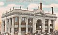
The Strathglass Building in 1907
-
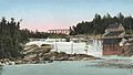
Pennacook Falls around 1905
-
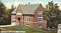
Public library around 1907, a Carnegie library
-
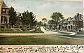
Strathglass Park housing around 1910


See also
 In Spanish: Rumford (Maine) para niños
