
Shrewsbury, Massachusetts facts for kids
Quick facts for kids
Shrewsbury, Massachusetts
|
||
|---|---|---|

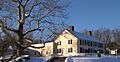
Homestead of General Artemas Ward
|
||
|
||

Location in Worcester County and the state of Massachusetts
|
||
| Country | United States | |
| State | Massachusetts | |
| County | Worcester | |
| Settled | 1722 | |
| Incorporated | 1727 | |
| Government | ||
| • Type | Representative town meeting | |
| Area | ||
| • Total | 21.7 sq mi (56.1 km2) | |
| • Land | 20.7 sq mi (53.7 km2) | |
| • Water | 0.9 sq mi (2.4 km2) | |
| Elevation | 668 ft (204 m) | |
| Population
(2020)
|
||
| • Total | 38,325 | |
| • Density | 1,851.4/sq mi (713.7/km2) | |
| Time zone | UTC−5 (Eastern) | |
| • Summer (DST) | UTC−4 (Eastern) | |
| ZIP Code |
01545
|
|
| Area code(s) | 508 / 774 | |
| FIPS code | 69-60165 | |
| GNIS feature ID | 619489 | |
| Website | www.shrewsburyma.gov | |

Shrewsbury is a town in Worcester County, Massachusetts, USA. About 38,325 people live here, based on the 2020 United States Census.
The town was officially formed in 1727. In the 1800s, Shrewsbury grew because it was close to Worcester. Many visitors also came to Lake Quinsigamond. Today, the town is run by a Town Manager and five elected members of the Select Board.
Contents
History of Shrewsbury

The town of Shrewsbury is named after Shrewsbury, England. It is a hilly area with small streams. These streams were useful for water power. Land grants for the area started in 1664. The largest was a 3,200-acre grant called Haynes Farm.
The first settlers came mainly from Sudbury and Marlborough. Gersham Wheelock was the first permanent settler in 1720. Shrewsbury was settled in 1722 and became an official town in 1727.
Early Economy and Challenges
Early townspeople focused on farming, especially apple orchards. By 1750, Shrewsbury had stores, taverns, and small businesses. After the American Revolutionary War, prices for farm goods dropped. There was also a shortage of money. This caused hard times for many people.
In 1786, a protest called Shays' Rebellion happened. People wanted to stop courts from collecting debts. Shrewsbury became a gathering place for over 400 protesters. They marched from here to the Worcester Court House.
Growth of Industries
A leather industry started in Shrewsbury in 1786. Farmers raised many cattle to support the making of boots and shoes. In 1797, gunsmiths began making rifles, shotguns, and pistols. They also made cutlery.
Luther Goddard started making brass clocks in 1809. Later, he opened a small watch factory. It employed skilled watchmakers from Switzerland and England. Lumbering led to sawmills, which then helped chair makers, cabinet makers, and wagon builders.
Modern Development
In the 1800s, streetcar routes helped new homes to be built. People visiting Lake Quinsigamond in the summer bought fresh produce from local farmers. Shrewsbury's industries slowed down because it lacked large water power and the railroad arrived late.
The town then became more important as a suburb of Worcester. From 1915 to 1940, the population doubled. More modern settlers moved in as streetcar lines expanded. Lakeside cottages, clubs, and recreation areas also grew around the lake. Today, Shrewsbury's economy relies on farming, tourism, and providing services for Worcester's population.
Historic Places to Visit
Shrewsbury has several places listed on the National Register of Historic Places. These are important sites that tell about the town's past:
- The Gen. Artemas Ward Homestead on Main Street.
- The Shrewsbury Historic District in the town center. This area includes parts of Church Road, Main Street, Prospect Street, Boylston Street, and Grafton Street.
- Two 1767 Milestones along the old Boston Post Road. These stones marked distances for travelers long ago.
Geography and Climate
Shrewsbury is a suburb of Worcester. It is about 45 minutes from Boston. You can reach downtown Worcester in about 10 minutes.
The town covers about 21.6 square miles (56.1 km2). Most of this area, 20.7 square miles (53.7 km2), is land. The rest, 0.9 square miles (2.4 km2), is water.
Neighboring Towns
Shrewsbury is surrounded by several other towns:
 |
West Boylston | Boylston | |
|
| Worcester | Northborough | |||
| Grafton | Westborough |
Weather in Shrewsbury
Shrewsbury has a typical New England climate. Summers are warm, and winters are cold with snow.
| Climate data for Shrewsbury, Massachusetts | |||||||||||||
|---|---|---|---|---|---|---|---|---|---|---|---|---|---|
| Month | Jan | Feb | Mar | Apr | May | Jun | Jul | Aug | Sep | Oct | Nov | Dec | Year |
| Record high °F | 64 | 70 | 83 | 90 | 97 | 96 | 96 | 98 | 96 | 86 | 78 | 69 | 98 |
| Mean daily maximum °F | 33 | 36 | 44 | 55 | 68 | 76 | 81 | 79 | 71 | 61 | 50 | 38 | 58 |
| Mean daily minimum °F | 15 | 17 | 26 | 37 | 48 | 57 | 63 | 61 | 52 | 40 | 32 | 22 | 39 |
| Record low °F | −26 | −15 | −6 | 13 | 28 | 34 | 42 | 36 | 28 | 18 | 9 | −10 | −26 |
| Average precipitation inches | 4.20 | 3.48 | 4.27 | 4.36 | 3.94 | 3.93 | 3.80 | 4.26 | 4.11 | 4.33 | 4.46 | 3.99 | 49.13 |
| Record high °C | 18 | 21 | 28 | 32 | 36 | 36 | 36 | 37 | 36 | 30 | 26 | 21 | 37 |
| Mean daily maximum °C | 1 | 2 | 7 | 13 | 20 | 24 | 27 | 26 | 22 | 16 | 10 | 3 | 14 |
| Mean daily minimum °C | −9 | −8 | −3 | 3 | 9 | 14 | 17 | 16 | 11 | 4 | 0 | −6 | 4 |
| Record low °C | −32 | −26 | −21 | −11 | −2 | 1 | 6 | 2 | −2 | −8 | −13 | −23 | −32 |
| Average precipitation mm | 107 | 88 | 108 | 111 | 100 | 100 | 97 | 108 | 104 | 110 | 113 | 101 | 1,247 |
| Source: Weather.com | |||||||||||||
People of Shrewsbury
| Historical population | ||
|---|---|---|
| Year | Pop. | ±% |
| 1850 | 1,596 | — |
| 1860 | 1,558 | −2.4% |
| 1870 | 1,610 | +3.3% |
| 1880 | 1,500 | −6.8% |
| 1890 | 1,449 | −3.4% |
| 1900 | 1,626 | +12.2% |
| 1910 | 1,946 | +19.7% |
| 1920 | 3,708 | +90.5% |
| 1930 | 6,910 | +86.4% |
| 1940 | 7,586 | +9.8% |
| 1950 | 10,594 | +39.7% |
| 1960 | 16,622 | +56.9% |
| 1970 | 19,196 | +15.5% |
| 1980 | 22,674 | +18.1% |
| 1990 | 24,146 | +6.5% |
| 2000 | 31,640 | +31.0% |
| 2010 | 35,608 | +12.5% |
| 2020 | 38,325 | +7.6% |
| 2023 | 38,889 | +1.5% |
Source: United States Census records and Population Estimates Program data. |
||
In 2020, the population of Shrewsbury was 38,325 people.
Diversity in Shrewsbury
Based on the 2020 United States Census, the town's population is made up of:
- 64.1% White
- 2.5% African American
- 24.6% Asian
- 6.5% from two or more races
- 4.2% of the population were Hispanic or Latino (of any race).
Households and Families
In 2020, there were 14,966 households in Shrewsbury.
- 34.5% of these households had children under 18 living with them.
- 60.1% were married couples living together.
- The average household had 2.54 people.
- The average family had 3.09 people.
The median age in Shrewsbury was 38 years old. About 25.6% of the population was under 18.
Economy and Businesses
Shrewsbury has been home to some interesting businesses:
- Hebert Candies: This is where white chocolate was first made in the United States.
- Spag's: This was a large store that sold many different things. It was like early versions of stores such as Costco or Walmart. It is now a shopping area.
- White City: This used to be an amusement park. Now, it is a shopping plaza.
Arts and Culture

Shrewsbury has several places that are important for its history and culture.
Local Library

The Shrewsbury Public Library first opened in 1872. It was made bigger in 1978. A brand new, larger library opened in 2016. It is about 42,000 square feet (3,900 m2).
Parks and Recreation
Shrewsbury offers many places for fun and outdoor activities:
- Ski Ward: This is a place where you can ski, snowboard, and snowtube all year round.
- Prospect Park: This is a 71-acre (29 ha) forest. It has trails for walking, running, and biking.
- Jordan Pond Recreational area: This area has 0.8 miles (1.3 km) of trails around Jordan Pond.
- Dean Park: This park has 1.8 miles (2.9 km) of hiking trails.
Education in Shrewsbury
Public Schools

Shrewsbury Public Schools is the public school district for the town. It includes:
- One preschool: Parker Road Preschool
- Five elementary schools (grades K–4): Major Howard W. Beal School, Floral Street School, Spring Street School, Walter J. Paton Elementary School, and Calvin Coolidge Elementary School.
- Two middle schools: Sherwood Middle School (grades 5–6) and Oak Middle School (grades 7–8).
- One high school: Shrewsbury High School.
Private Schools

Shrewsbury also has private schools:
- Shrewsbury Montessori: This school offers programs for Pre-K through grade 6.
- St. Mary's School: This is a Catholic school for Pre-K through grade 8.
- Saint John's High School: This is a private high school sponsored by the Xaverian Brothers.
Notable People
Many interesting people have connections to Shrewsbury:
- Kenneth S. Apfel (born 1948): He was the 13th Commissioner of Social Security.
- Lillian Asplund (1906–2006): She was the last American survivor of the Titanic sinking.
- Mike Birbiglia (born 1978): A well-known stand-up comedian.
- Ralph Earl (1751–1801): An American painter famous for his portrait of Roger Sherman.
- Jesse Livermore (1877–1940): A pioneering stock trader.
- Gregory Mcdonald (1937–2008): Author of the Fletch series of novels.
- Craig Mello (born 1960): He won the 2006 Nobel Prize in Physiology or Medicine.
- Robert Allan Ridley Parker (born 1936): A director at NASA's Jet Propulsion Laboratory.
- Charlie Pierce (born 1953): An American writer and journalist.
- Karyn Polito (born 1966): She was the 72nd Lieutenant Governor of Massachusetts.
- Simon Lizotte (born 1992): A professional disc golfer from Germany and America.
- Teddy Quinlivan (born 1994): A transgender fashion model.
- Artemas Ward (1727–1800): An American Major General in the American Revolutionary War. He was also a Congressman from Massachusetts.
Images for kids
-
Homestead of General Artemas Ward
See also
 In Spanish: Shrewsbury (Massachusetts) para niños
