
Worcester County, Massachusetts facts for kids
Quick facts for kids
Worcester County
|
||
|---|---|---|
|
||

Location within the U.S. state of Massachusetts
|
||
 Massachusetts's location within the U.S. |
||
| Country | ||
| State | ||
| Founded | April 2, 1731 | |
| Named for | Worcester, Massachusetts | |
| Seat | Worcester | |
| Largest city | Worcester | |
| Area | ||
| • Total | 1,579 sq mi (4,090 km2) | |
| • Land | 1,511 sq mi (3,910 km2) | |
| • Water | 68 sq mi (180 km2) | |
| Population
(2020)
|
||
| • Total | 862,111 | |
| • Estimate
(2024)
|
881,248 |
|
| • Density | 570.7/sq mi (220.3/km2) | |
| Time zone | UTC−5 (Eastern) | |
| • Summer (DST) | UTC−4 (EDT) | |
| Congressional districts | 1st, 2nd, 3rd, 4th | |


.jpg)


Worcester County (pronounced WUUST-er) is a large and important area in the state of Massachusetts, USA. It's known for being the biggest county in Massachusetts by land area, covering about 1,511 square miles. In 2020, over 862,000 people lived here, making it the second most populated county in the state. The biggest city and main town is Worcester. This county is also part of a larger area that includes parts of Connecticut, known as the Worcester metropolitan area.
Contents
A Look Back in Time: Worcester County's History
Worcester County was created a long time ago, on April 2, 1731. It was formed from parts of other older counties like Hampshire, Middlesex, and Suffolk. When the county government started, the town of Worcester was chosen as its main administrative center, also called the "shire town."
Because Worcester County is so big, people tried many times over the years to divide it into two smaller counties. There were 15 attempts in 140 years, but none of them worked out. Towns like Lancaster and Fitchburg were suggested as new main towns for a northern county. As a compromise, in 1884, the county's record-keeping office (called the Registry of Deeds) was split, and a new office was opened in Fitchburg.
Worcester County's Geography and Neighbors
Worcester County covers a total area of about 1,579 square miles. Most of this (about 1,511 square miles) is land, and the rest (about 68 square miles) is water. It's the largest county in Massachusetts by size, even bigger than the entire state of Rhode Island!
This county is located in the middle of Massachusetts, often called "Central Massachusetts." It helps separate the Springfield area from the Boston area. It also stretches all the way from the northern border to the southern border of the state. The exact middle point of Massachusetts is found in the town of Rutland.
Worcester County is special because it borders three different states: New Hampshire, Connecticut, and Rhode Island. Only one other county in Massachusetts does this.
Nearby Counties
- Cheshire County, New Hampshire - north
- Hillsborough County, New Hampshire - north/northeast
- Middlesex County - east/northeast
- Norfolk County - east/southeast
- Providence County, Rhode Island - south/southeast
- Windham County, Connecticut - south
- Tolland County, Connecticut - south/southwest
- Hampden County - west/southwest
- Hampshire County - west
- Franklin County - west/northwest
Special Protected Areas
People and Population in Worcester County
| Historical population | |||
|---|---|---|---|
| Census | Pop. | %± | |
| 1790 | 56,764 | — | |
| 1800 | 61,192 | 7.8% | |
| 1810 | 64,910 | 6.1% | |
| 1820 | 73,625 | 13.4% | |
| 1830 | 84,355 | 14.6% | |
| 1840 | 95,313 | 13.0% | |
| 1850 | 130,789 | 37.2% | |
| 1860 | 159,659 | 22.1% | |
| 1870 | 192,716 | 20.7% | |
| 1880 | 226,897 | 17.7% | |
| 1890 | 280,787 | 23.8% | |
| 1900 | 346,958 | 23.6% | |
| 1910 | 399,657 | 15.2% | |
| 1920 | 455,135 | 13.9% | |
| 1930 | 491,242 | 7.9% | |
| 1940 | 504,470 | 2.7% | |
| 1950 | 546,401 | 8.3% | |
| 1960 | 583,228 | 6.7% | |
| 1970 | 637,969 | 9.4% | |
| 1980 | 646,352 | 1.3% | |
| 1990 | 709,705 | 9.8% | |
| 2000 | 750,963 | 5.8% | |
| 2010 | 798,552 | 6.3% | |
| 2020 | 862,111 | 8.0% | |
| 2024 (est.) | 881,248 | 10.4% | |
| U.S. Decennial Census 1790-1960 1900-1990 1990-2000 2010 2020 |
|||
In 2020, the population of Worcester County was 862,111 people. About 20.7% of the residents were under 18 years old, and 16.4% were 65 or older. The average age was about 40 years old. Most people (78.8%) lived in cities and towns, while 21.2% lived in more rural areas.
The county is home to a diverse group of people. In 2020, the population was made up of many different backgrounds. The largest group was White residents, making up about 73.6% of the population. Other groups included Black or African American (5.6%), Asian (5.4%), and American Indian and Alaska Native (0.3%). About 8.7% of residents identified with two or more races. People of Hispanic or Latino origin made up 13.0% of the population.
There were over 331,000 homes in the county. In about 29.9% of these homes, children under 18 lived there. Many homes were owned by the people living in them (63.8%), while others were rented (36.2%).
| Race / Ethnicity (NH = Non-Hispanic) | Pop 2000 | Pop 2010 | Pop 2020 | % 2000 | % 2010 | % 2020 |
|---|---|---|---|---|---|---|
| White alone (NH) | 649,227 | 644,299 | 611,207 | 86.45% | 80.68% | 70.89% |
| Black or African American alone (NH) | 18,257 | 29,084 | 44,222 | 2.43% | 3.64% | 5.12% |
| Native American or Alaska Native alone (NH) | 1,499 | 1,298 | 1,146 | 0.19% | 0.16% | 0.13% |
| Asian alone (NH) | 19,561 | 31,597 | 46,110 | 2.60% | 3.95% | 5.34% |
| Pacific Islander alone (NH) | 188 | 178 | 176 | 0.02% | 0.02% | 0.02% |
| Other race alone (NH) | 1,686 | 3,634 | 9,424 | 0.22% | 0.45% | 1.09% |
| Mixed race or Multiracial (NH) | 9,681 | 13,040 | 37,924 | 1.28% | 1.63% | 4.39% |
| Hispanic or Latino (any race) | 50,864 | 75,422 | 111,902 | 6.77% | 9.44% | 12.97% |
| Total | 750,963 | 798,552 | 862,111 | 100.00% | 100.00% | 100.00% |
How Worcester County is Governed
| County-level state agency heads | |
|---|---|
| Clerk of Courts: | Dennis P. McManus (D) |
| District Attorney: | Joseph D. Early, Jr. (D) |
| Register of Deeds: | Anthony J. Vigliotti (D) |
| Register of Probate: | Stephanie K. Fattman (R) |
| County Sheriff: | Lew Evangelidis (R) |
| State government | |
| State Representative(s): | by community |
| State Senator(s): | by community |
| Governor's Councilor(s): | Paul M. DePalo (D) |
| Federal government | |
| U.S. Representative(s): | by Congressional district |
| U.S. Senators: | Elizabeth Warren (D), Ed Markey (D) |
Worcester County is one of eight counties in Massachusetts that no longer has a traditional county government. Since July 1, 1998, many of the jobs that county governments used to do are now handled by state agencies.
However, there are still some important elected officials for the county. These include a county sheriff, who is in charge of corrections and court services, and a county prosecutor, called the District Attorney. These officials work with the state's public safety department. The county also has a regional planning commission that helps with planning for the area.
The current Worcester County Sheriff is Lewis Evangelidis (R), and the District Attorney is Joseph Early Jr. (D). These leaders are elected by the people of the county to serve for six-year terms.
Cities and Towns in Worcester County

Cities
- Fitchburg
- Gardner
- Leominster
- Southbridge
- Worcester (the main county town)
Towns
- Ashburnham
- Athol
- Auburn
- Barre
- Berlin
- Blackstone
- Bolton
- Boylston
- Brookfield
- Charlton
- Clinton
- Douglas
- Dudley
- East Brookfield
- Grafton
- Hardwick
- Harvard
- Holden
- Hopedale
- Hubbardston
- Lancaster
- Leicester
- Lunenburg
- Mendon
- Milford
- Millbury
- Millville
- New Braintree
- North Brookfield
- Northborough
- Northbridge
- Oakham
- Oxford
- Paxton
- Petersham
- Phillipston
- Princeton
- Royalston
- Rutland
- Shrewsbury
- Southborough
- Spencer
- Sterling
- Sturbridge
- Sutton
- Templeton
- Upton
- Uxbridge
- Warren
- Webster
- West Boylston
- West Brookfield
- Westborough
- Westminster
- Winchendon
Census-Designated Places
- Athol
- Baldwinville
- Barre
- Brookfield
- Clinton
- Cordaville
- Devens
- East Brookfield
- East Douglas
- Fiskdale
- Hopedale
- Lunenburg
- Milford
- North Brookfield
- Northborough
- Oxford
- Petersham
- Rutland
- South Ashburnham
- South Lancaster
- Spencer
- Sturbridge
- Upton
- Warren
- Webster
- West Brookfield
- West Warren
- Westborough
- Whitinsville
- Winchendon
Other Small Communities
- Chapinville
- Cherry Valley
- East Millbury
- East Princeton
- Farnumsville (also called South Grafton)
- Fisherville
- Gilbertville
- Hardwick
- Ironstone (also known as South Uxbridge)
- Jefferson
- Leicester Center
- Linwood
- Manchuag
- Morningdale
- North Grafton
- North Uxbridge
- Oakdale
- Old Furnace
- Otter River
- Pitcherville
- Rochdale
- Rockdale
- Saundersville
- Spindleville
- Still River
- Stoneville
- West Sutton
- West Upton
- Whalom
- Wheelockville
- Wheelwright
- Winchendon Springs
Ghost Town
- Dana, a town that was removed to create the Quabbin Reservoir.
Famous People from Worcester County
Many interesting and important people have connections to Worcester County:
- Louisa May Alcott, a famous novelist who wrote "Little Women."
- Johnny Appleseed, whose real name was Jonathan Chapman, known for planting apple trees.
- Clara Barton, the amazing founder of the American Red Cross.
- Robert Benchley, a writer, actor, and humorist.
- Luther Burbank, a horticulturalist who developed the russet potato.
- William Cullen Bryant, a well-known poet and journalist.
- George M. Cohan, a talented entertainer, playwright, and composer.
- Robert Cormier, a novelist and columnist.
- Ron Darling, a professional baseball pitcher.
- Dorothea Dix, a social reformer and activist.
- Ralph Earl, a famous portrait painter from early America.
- Fannie Farmer, a well-known cookbook author.
- Abby Kelley Foster, an important activist for ending slavery and women's right to vote.
- Rich Gedman, a professional baseball catcher for the Boston Red Sox.
- Robert H. Goddard, often called the father of American rocketry.
- Gabby Hartnett, considered one of the greatest baseball catchers.
- Elias Howe, who invented the sewing machine.
- Elliott P. Joslin, a pioneer in diabetes research.
- Connie Mack, a baseball legend and long-time manager.
- Agnes Moorehead, a famous actress.
- William T. G. Morton, who helped develop modern anesthesia.
- Joe Perry, the songwriter and guitarist for the band Aerosmith.
- Brian Skerry, an underwater photographer for National Geographic.
- Steve Spagnuolo, a successful coach in American football.
- Lucy Stone, a famous advocate for women's rights and the first woman college graduate in Massachusetts.
- Lydia Chapin Taft, America's first woman voter.
- Earl Tupper, who created Tupperware.
- Artemas Ward, a major general during the American Revolution.
- Daniel B. Wesson, co-founder of Smith & Wesson, a firearm manufacturer.
- Eli Whitney, who invented the cotton gin.
- Scott Young, a professional hockey player and two-time Stanley Cup champion.
Images for kids
-
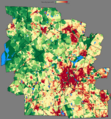
Population density of Worcester County by census block (2020)

See also
 In Spanish: Condado de Worcester (Massachusetts) para niños
- List of Massachusetts locations by per capita income
- List of counties in Massachusetts
- Registry of Deeds (Massachusetts) Worcester County District Registry of Deeds
- National Register of Historic Places listings in Worcester County, Massachusetts
