
Petersham, Massachusetts facts for kids
Quick facts for kids
Petersham, Massachusetts
|
||
|---|---|---|

|
||
|
||

Location in Worcester County and the state of Massachusetts.
|
||
| Country | United States | |
| State | Massachusetts | |
| County | Worcester | |
| Settled | 1733 | |
| Incorporated | 1754 | |
| Government | ||
| • Type | Open town meeting | |
| Area | ||
| • Total | 68.3 sq mi (176.9 km2) | |
| • Land | 54.2 sq mi (140.5 km2) | |
| • Water | 14.1 sq mi (36.4 km2) | |
| Elevation | 1,080 ft (329 m) | |
| Population
(2020)
|
||
| • Total | 1,194 | |
| • Density | 17.482/sq mi (6.750/km2) | |
| Time zone | UTC-5 (Eastern) | |
| • Summer (DST) | UTC-4 (Eastern) | |
| ZIP code |
01366
|
|
| Area code(s) | 351 / 978 | |
| FIPS code | 25-53120 | |
| GNIS feature ID | 0619486 | |

Petersham is a small town in Worcester County, Massachusetts, United States. In 2020, about 1,194 people lived here. Petersham is known for its beautiful natural areas. These include the Quabbin Reservation and Harvard Forest. It also has the Swift River Reservation and the Federated Women's Club State Forest.
Contents
History of Petersham
When was Petersham first settled?
Petersham was first settled by European people in 1733. It officially became a town on April 20, 1754.
What happened during Shays' Rebellion in Petersham?
On February 4, 1787, Petersham was the site of an important event. This was the second battle of Shays' Rebellion. This rebellion was a protest by farmers who were upset about taxes. General Benjamin Lincoln led 3,000 troops to Petersham. They quickly ended the rebellion there. A memorial was built in 1927 to remember this event. It reminds everyone that "Obedience to the law is true liberty."
How did the Quabbin Reservoir change Petersham?
The town's land grew a lot when the Quabbin Reservoir was built in 1938. This huge reservoir provides drinking water. When nearby towns were closed to make space for the reservoir, Petersham gained land. It received all of the former town of Dana. It also got much of Greenwich and a small part of Prescott.
What is the Petersham Common?
Petersham is famous for its town common. This is a large open space in the center of town. It is part of the Petersham Common Historic District. About 45 buildings in this area are listed on the National Register of Historic Places. The Country Store, built in 1842, is a historic building. It has been a general store since it first opened.
Geography and Transportation in Petersham
How big is Petersham?
Petersham is a large town in terms of land area. It covers about 68.3 square miles (176.9 square kilometers). About 54.2 square miles (140.5 square kilometers) is land. The rest, 14.1 square miles (36.4 square kilometers), is water. This makes Petersham the largest town by land area in Worcester County. It is also the fifth-largest town in all of Massachusetts.
What natural areas are in Petersham?
Much of Petersham's land is protected. This includes the Quabbin Reservation. This area surrounds the Quabbin Reservoir. The town's borders reach into the eastern part of the reservoir. This includes land that was once hills like Mount Pomeroy and Mount Zion. These lands are mostly for walking and exploring. You can visit the former Dana Common, which is about a 1.5-mile walk from Gate 40.
Petersham also has other hills. These are part of the Worcester Hills region. Whitney Hill and Camels Hump Hill are examples. Camels Hump Hill is the highest point in town, at 1,044 feet (318 meters). Many other parts of the town are also protected. These include:
- Federated Women's Club State Forest
- Petersham State Forest
- Harvard State Forest
- Popple Camp Wildlife Management Area
- Phillipston Wildlife Management Area
Most of Petersham is rural, meaning it has a lot of open land and few buildings. The main population center is near the town common. This area is called the village of Petersham.
Where is Petersham located?
Petersham is the westernmost town in Worcester County. It borders Franklin County to the west. It also touches a small part of Hampshire County to the south. Petersham is next to several other towns:
- Athol to the northwest
- Phillipston to the northeast
- Barre and Hardwick to the southeast
- Ware to the south
- New Salem to the west
From the town common, Petersham is about 29 miles (47 km) northwest of Worcester. It is also 41 miles (66 km) north-northeast of Springfield. Boston is about 66 miles (106 km) west-northwest of Petersham.
How do people travel in Petersham?
There are no major highways like interstates in Petersham. The closest main road is Route 2. This road goes east and west across northern Massachusetts. It is just north of Petersham.
Near the center of town, Route 32 and Route 122 meet. Route 32 comes from Athol. Route 122 comes from New Salem. These routes go together into Barre before splitting up. Route 32A also starts in Petersham. It heads south through Hardwick. Route 101 starts just north of the town center. It goes into Phillipston.
Petersham does not have public transportation like buses or trains. The closest small airports are:
- Orange Municipal Airport
- Gardner Municipal Airport
- Tanner-Hiller Airport in Barre
For bigger flights, the nearest airport is Bradley International Airport in Connecticut.
Education in Petersham
Petersham has one public elementary school. It is called the Petersham Center School. Students from kindergarten through sixth grade attend this school. For high school, students go to Ralph C. Mahar Regional High School. This school is located in Orange.
Petersham Demographics
Who lives in Petersham?
In 2000, there were 1,180 people living in Petersham. There were 438 households, which are groups of people living together. About 299 of these were families. The town had about 21.8 people per square mile (8.4 per square kilometer).
Most people in Petersham were White (97.20%). A small number were African American (0.68%), Native American (0.76%), or Asian (0.25%). About 1.02% were from two or more races. About 1.10% of the population was Hispanic or Latino.
What is the age range of Petersham residents?
The population in Petersham was spread out by age:
- 22.4% were under 18 years old.
- 4.3% were between 18 and 24 years old.
- 27.0% were between 25 and 44 years old.
- 28.7% were between 45 and 64 years old.
- 17.5% were 65 years old or older.
The average age in town was 43 years. For every 100 females, there were about 101.4 males.
What are the incomes in Petersham?
In 2000, the average income for a household in Petersham was $47,833. For families, the average income was $58,125. The average income per person in the town was $24,222. About 2.0% of families and 5.8% of all people lived below the poverty line. This included 4.2% of those under 18 and 1.5% of those 65 or older.
Petersham Public Library

The Petersham public library first opened in 1879. In 2008, the town spent about $10,752 on its library. This was about $8 per person each year. The Nichewaug Inn and the Petersham Center School were both designed by the same company, Stone, Carpenter & Willson.
Places to Visit in Petersham
Petersham has several interesting places to visit:
- The Country Store
- Petersham Curling Club
- Fisher Museum, Harvard Forest
- Petersham Historical Society Museum
- Most Holy Trinity Monastery
Notable People from Petersham
Many interesting people have connections to Petersham:
- Lewis Bigelow, a congressman
- Yodelin' Slim Clark, a musician
- Dorothy Eaton (1893–1968), a painter
- Austin Flint, a physician
- James Hawkes, a congressman
- Jonas Howe (1786–1865), a Massachusetts state lawmaker
- Emmeline B. Wells, a journalist and activist
- Solomon Willard, who helped build the famous Bunker Hill Monument
Images for kids
-
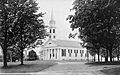
Petersham Common
-
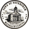
Seal of Petersham, Massachusetts
-
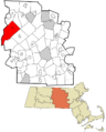
Location in Worcester County and the state of Massachusetts.
-
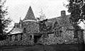
Petersham Public Library, 1899
See also
 In Spanish: Petersham (Massachusetts) para niños
