Franklin County, Massachusetts facts for kids
Quick facts for kids
Franklin County
|
||
|---|---|---|

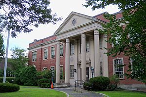
Franklin County Courthouse in Greenfield
|
||
|
||

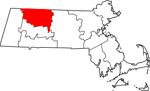
Location within the U.S. state of Massachusetts
|
||
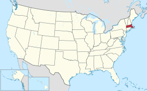
 Massachusetts's location within the U.S. |
||
| Country | ||
| State | ||
| Founded | 1811 | |
| Named for | Benjamin Franklin | |
| Seat | Greenfield | |
| Largest city | Greenfield | |
| Area | ||
| • Total | 725 sq mi (1,880 km2) | |
| • Land | 699 sq mi (1,810 km2) | |
| • Water | 25 sq mi (60 km2) 3.5% | |
| Population
(2020)
|
||
| • Total | 71,029 | |
| • Estimate
(2023)
|
70,836 |
|
| • Density | 97.97/sq mi (37.827/km2) | |
| Time zone | UTC−5 (Eastern) | |
| • Summer (DST) | UTC−4 (EDT) | |
| Congressional districts | 1st, 2nd | |
Franklin County is a special kind of county in the northwestern part of Massachusetts, a state in the U.S.. Unlike many counties, it doesn't have its own government anymore.
In 2020, about 71,029 people lived here. This makes it the county with the fewest people on the mainland of Massachusetts, and the third smallest in the whole state. The main town, and where most people live, is Greenfield. The biggest town by land area is New Salem.
Contents
History of Franklin County
Franklin County was created a long time ago, on June 24, 1811. It was formed from the northern part of Hampshire County. The county was named after the famous American inventor and statesman, Benjamin Franklin.
Later, in 1997, the state government stopped the county's own government. This happened because the county itself asked for it.
Geography and Climate
Franklin County covers about 725 square miles. Most of this area, about 699 square miles, is land, and about 25 square miles is water.
The middle and southern parts of Franklin County have many hills and valleys. This area is known as the northern end of the Pioneer Valley. The Connecticut River flows through here, with steep hills rising on both sides.
The highest point in Franklin County is a place called Crum Hill. It stands tall at 2,841 feet (866 meters) and is located in the town of Monroe.
Weather in Franklin County
The weather in Franklin County is usually cool. It also gets a good amount of rain and snow throughout the year.
- Summers are warm and humid. You can expect frequent thunderstorms in the evenings.
- Winters are cool to cold. It often snows, and temperatures usually drop below freezing (31 °F or -0.5 °C).
Protected Natural Areas
Franklin County has several places where nature is protected:
- Silvio O. Conte National Fish and Wildlife Refuge (part of it is in the county)
- Paul C. Jones Working Forest (a private forest with special rules to protect it)
- Various properties managed by the Department of Conservation & Recreation.
People of Franklin County
Here's how the population of Franklin County has changed over the years:
| Historical population | |||
|---|---|---|---|
| Census | Pop. | %± | |
| 1820 | 29,268 | — | |
| 1830 | 29,501 | 0.8% | |
| 1840 | 28,812 | −2.3% | |
| 1850 | 30,870 | 7.1% | |
| 1860 | 31,434 | 1.8% | |
| 1870 | 32,635 | 3.8% | |
| 1880 | 36,001 | 10.3% | |
| 1890 | 38,610 | 7.2% | |
| 1900 | 41,209 | 6.7% | |
| 1910 | 43,600 | 5.8% | |
| 1920 | 49,361 | 13.2% | |
| 1930 | 49,612 | 0.5% | |
| 1940 | 49,453 | −0.3% | |
| 1950 | 52,747 | 6.7% | |
| 1960 | 54,864 | 4.0% | |
| 1970 | 59,210 | 7.9% | |
| 1980 | 64,317 | 8.6% | |
| 1990 | 70,092 | 9.0% | |
| 2000 | 71,535 | 2.1% | |
| 2010 | 71,372 | −0.2% | |
| 2020 | 71,029 | −0.5% | |
| 2023 (est.) | 70,836 | −0.8% | |
| U.S. Decennial Census 1790–1960 1900–1990 1990–2000 2010–2018 |
|||
What the 2010 Census Showed
In 2010, there were 71,372 people living in Franklin County. These people lived in 30,462 homes, and 18,317 of those were families.
Most people in the county (94.2%) were white. Other groups included Asian (1.3%), Black (1.1%), and American Indian (0.3%). About 3.2% of the population was of Hispanic or Latino background.
People in Franklin County come from many different backgrounds. The largest ancestry groups included:
- 20.0% English
- 19.8% Irish
- 15.9% French
- 12.6% Polish
- 12.0% German
- 9.1% Italian
- 7.2% French Canadian
- 4.5% Scottish
- 3.9% American
- 2.1% Swedish
- 2.0% Scotch-Irish
- 1.8% Puerto Rican
- 1.5% Russian
- 1.3% Dutch
- 1.3% Portuguese
- 1.3% Lithuanian
- 1.0% Welsh
About 26.4% of homes had children under 18 living there. The average age of people in the county was 44.2 years old.
The average income for a household was about $52,002 per year, and for a family, it was about $65,760 per year. About 11.3% of all people in the county lived below the poverty line.
Getting Around Franklin County
Buses run by the Franklin Regional Transit Authority help people travel around Franklin County. The southeastern part of the county also has bus service from the Pioneer Valley Transit Authority, which connects to places in nearby Hampshire County.
Main Roads
Many important roads pass through Franklin County, making it easy to travel:
 I‑91
I‑91 US 5
US 5 US 202
 Route 2
 Route 2A
 Route 8A
 Route 10
 Route 47
 Route 63
 Route 78
 Route 112
 Route 116
 Route 122
Notable Person
- David Dunnels White: He was nominated for the Medal of Honor because he captured Major General Custis Lee (who was the son of Robert E. Lee) during a battle in 1865. David Dunnels White was born in Cheshire, Massachusetts, and was buried in East Hawley, Massachusetts.
Communities in Franklin County
Franklin County has one city and many towns, plus smaller communities.
City
- Greenfield (This is the main town, or "county seat," even though the county government is gone.)
Towns
Census-Designated Places (CDPs)
These are areas that the U.S. Census Bureau defines for gathering data, but they are not officially separate towns or cities.
Other Unincorporated Communities
These are smaller places that are not officially towns or CDPs.
See also
 In Spanish: Condado de Franklin (Massachusetts) para niños
 | Aaron Henry |
 | T. R. M. Howard |
 | Jesse Jackson |


