Leyden, Massachusetts facts for kids
Quick facts for kids
Leyden, Massachusetts
|
||
|---|---|---|

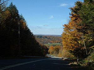
Frizzell Hill, looking west towards the town center
|
||
|
||

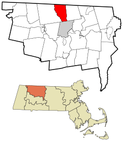
Location in Franklin County in Massachusetts
|
||
| Country | United States | |
| State | Massachusetts | |
| County | Franklin | |
| Settled | 1738 | |
| Incorporated | 1809 | |
| Government | ||
| • Type | Open town meeting | |
| Area | ||
| • Total | 18.0 sq mi (46.7 km2) | |
| • Land | 17.9 sq mi (46.4 km2) | |
| • Water | 0.1 sq mi (0.3 km2) | |
| Elevation | 833 ft (283 m) | |
| Population
(2020)
|
||
| • Total | 734 | |
| • Density | 40.71/sq mi (15.717/km2) | |
| Time zone | UTC−5 (Eastern) | |
| • Summer (DST) | UTC−4 (Eastern) | |
| ZIP Codes |
01301 and 01337
|
|
| Area code(s) | 413 | |
| FIPS code | 25-35285 | |
| GNIS feature ID | 0618169 | |
Leyden is a small town in Franklin County, Massachusetts, United States. In 2020, about 734 people lived there. Leyden is also part of the larger Springfield area.
Contents
History of Leyden: From Early Settlers to Today
Long ago, before English settlers arrived, the Wabanaki people lived in the area where Leyden is now. English colonists first settled here in 1737. It was part of a larger area called "Fall Town," which also included nearby places like Bernardston and Colrain.
Leyden became its own separate area from Bernardston in 1784. However, it wasn't officially recognized as a town until February 22, 1809. The town was named after Leiden, a city in the Netherlands. This city was a safe place for the Pilgrims before they sailed to America.
In the 1700s, Leyden had several small businesses. These included mills for grinding grain and making wood products. Dairy farming was also important. Today, the biggest industry in Leyden is making maple sugar. The town also has a reservoir that provides water to the nearby town of Greenfield.
In the 1790s, a group called the Dorrellites lived in Leyden. They were a unique community led by William Dorrell. Later, in 1968, another community called the Brotherhood of the Spirit started in Leyden.
Geography and Nature in Leyden
Leyden covers about 46.7 square kilometers (18.0 square miles). Most of this area, about 46.4 square kilometers (17.9 square miles), is land. The rest, about 0.3 square kilometers (0.1 square miles), is water.
Leyden is located right on the northern border of Massachusetts. It sits south of Windham County, Vermont. The town is surrounded by other towns: Guilford, Vermont to the north, Bernardston to the east, Greenfield to the south, and Colrain to the west.
The center of Leyden is about 9 miles (14 km) north of Greenfield. It's also about 47 miles (76 km) north of Springfield and 96 miles (154 km) west-northwest of Boston.
Leyden is on the eastern edge of the Berkshires, which are a range of hills. Much of the town is in the valleys of the Green River and the streams of Glen Brook. The Green River also forms the western border of the town. Most of Leyden away from the brooks is covered in forests. The town even has a small state forest and a wildlife management area.
The main and east branches of Glen Brook meet and are dammed to form the Greenfield Reservoir. This reservoir is an important water source. After the reservoir, the brook flows south into Greenfield and joins the Green River.
Getting Around Leyden: Roads and Transportation
Leyden is one of the few towns in Massachusetts that doesn't have any state highways. However, there are state roads, U.S. routes, and interstates in the towns nearby. For example, Interstate 91 passes to the south and east of Leyden.
If you need bus or train service, the closest options are in Greenfield. For small plane flights, Turners Falls has an airport. For national air travel, the nearest major airport is Bradley International Airport in Windsor Locks, Connecticut.
People and Population in Leyden
| Historical population | ||
|---|---|---|
| Year | Pop. | ±% |
| 1840 | 646 | — |
| 1850 | 716 | +10.8% |
| 1860 | 606 | −15.4% |
| 1870 | 518 | −14.5% |
| 1880 | 507 | −2.1% |
| 1890 | 407 | −19.7% |
| 1900 | 379 | −6.9% |
| 1910 | 363 | −4.2% |
| 1920 | 330 | −9.1% |
| 1930 | 261 | −20.9% |
| 1940 | 260 | −0.4% |
| 1950 | 306 | +17.7% |
| 1960 | 343 | +12.1% |
| 1970 | 376 | +9.6% |
| 1980 | 498 | +32.4% |
| 1990 | 662 | +32.9% |
| 2000 | 772 | +16.6% |
| 2010 | 711 | −7.9% |
| 2020 | 734 | +3.2% |
| 2022 | 734 | +0.0% |
Source: United States Census records and Population Estimates Program data. |
||
According to the census of 2000, there were 772 people living in Leyden. There were 277 households, and 219 of these were families. Leyden was one of the smaller towns in Franklin County by population.
Most people in Leyden were White (98.45%). A small number of people were African American, Native American, Asian, or from two or more races. About 0.26% of the population was Hispanic or Latino.
About 37.5% of households had children under 18 living with them. Most households (68.2%) were married couples living together. The average household had about 2.78 people, and the average family had about 3.08 people.
The population in Leyden was spread out by age. About 26.9% were under 18 years old. The median age was 40 years. This means half the people were older than 40 and half were younger.
The median income for a household in Leyden was $50,385. For families, the median income was $53,750. A small percentage of families (3.4%) and people (4.7%) lived below the poverty line.
Education in Leyden
Leyden is part of the Pioneer Valley Regional School District. This district includes several towns along the northern border. The elementary schools in these towns used to be semi-independent. However, as of 2019, Pearl Rhodes Elementary School in Leyden has closed. Now, students from Leyden attend Bernardston Elementary School for kindergarten through sixth grade.
For grades seven through twelve, students from Leyden go to Pioneer Valley Regional School in Northfield. There are also private and charter schools in Greenfield and other nearby towns. A well-known private school is Deerfield Academy in nearby Deerfield.
For higher education, the closest community college is Greenfield Community College in Greenfield. The nearest state college is Massachusetts College of Liberal Arts in North Adams. The closest state university is the University of Massachusetts Amherst. There are also private colleges, including members of the Five Colleges, located southeast in the Northampton area.
Notable People from Leyden
- Henry Kirke Brown (1814–1886): A famous sculptor. He created well-known statues, like the equestrian (on horseback) statues of Winfield Scott in Washington, D.C., and George Washington in Union Square in New York City.
- Charles C. Carpenter (1834–1899): A United States Navy rear admiral. He rose through the ranks to command the Asiatic Squadron.
- Charles N. Davenport (1830–1882): A lawyer and politician from Vermont.
- John Leonard Riddell (1807–1865): A noted scientist, author, and politician. He invented the first practical binocular microscope. He also worked at the New Orleans Mint during the American Civil War.
See also
 In Spanish: Leyden (Massachusetts) para niños
 | William Lucy |
 | Charles Hayes |
 | Cleveland Robinson |


