Guilford, Vermont facts for kids
Quick facts for kids
Guilford, Vermont
|
|
|---|---|

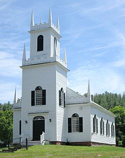
Christ Church, built in 1817
(2013) |
|

Guilford, Vermont
|
|
| Country | United States |
| State | Vermont |
| County | Windham |
| Communities |
|
| Area | |
| • Total | 40.0 sq mi (103.5 km2) |
| • Land | 39.9 sq mi (103.3 km2) |
| • Water | 0.1 sq mi (0.2 km2) |
| Elevation | 791 ft (241 m) |
| Population
(2020)
|
|
| • Total | 2,120 |
| • Density | 53/sq mi (20.5/km2) |
| Time zone | UTC-5 (Eastern (EST)) |
| • Summer (DST) | UTC-4 (EDT) |
| ZIP code |
05301
|
| Area code(s) | 802 |
| FIPS code | 50-30925 |
| GNIS feature ID | 1462112 |
| Website | guilfordvt.org |
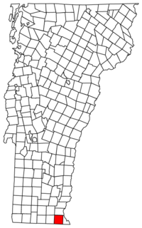
Guilford is a town in Windham County, Vermont, United States. It's located in the beautiful state of Vermont. The town was named after Francis North, 1st Earl of Guilford. In 2020, about 2,120 people called Guilford home.
Contents
Where is Guilford?
Guilford covers an area of about 40 square miles (103.5 square kilometers). Most of this area is land. Only a very small part, about 0.1 square miles (0.2 square kilometers), is water.
Who Lives in Guilford?
|
||||||||||||||||||||||||||||||||||||||||||||||||||||||||||||||||||||||||||||||||||||||||||||||||||||||||||||
In 2010, there were 2,121 people living in Guilford. These people lived in 902 different homes. Most people in Guilford are White. A small number of people are African American, Asian, or from other backgrounds. About 1% of the population is Hispanic or Latino.
Families and Age Groups
About a quarter of the homes in Guilford had children under 18 living there. Many homes were families with both parents. Some homes had a single mom or single dad.
The people in Guilford are of different ages. About 22% of the population is 19 years old or younger. About 38% are between 45 and 64 years old. The average age in Guilford is about 46 years.
How People Make a Living
In 2010, the average income for a household in Guilford was about $57,674 per year. For families, the average income was higher, around $77,431. A small number of families and people lived below the poverty line. This included about 12% of those under 18.
Guilford's History Timeline
Guilford has a long and interesting history. Here are some important dates:
- 1732 – The area was first named Gallup's Canada by Massachusetts.
- 1754 – It was then called Guilford by New Hampshire.
- 1758 – New York also claimed it as Guilford.
- 1760 or 1761 – The first settlers arrived. This was either Lucy Terry in 1760 or Michah Rice in 1761.
- 1782 – The first house and barn built in Guilford burned down.
- 1791 – Guilford officially became a town in Vermont.
- 1791-1820 – For a while, Guilford was the town with the most people in Vermont!
- 1816 – The first Episcopal church in Vermont was built here. It's called Christ Church.
- 1817 – The Broad Brook House was built. Today, it's the Guilford Country Store.
- 1822 – The first Guilford Town Hall was built. It is now a historical museum.
- 1900 – Local post offices closed when rural mail delivery started.
- 1957 – Guilford Central School was built. All the older, smaller schoolhouses closed.
- 1972 – The current Guilford Town Hall was built on School Road.
- 2007 – Guilford got its first full-time firefighter.
Famous People from Guilford
Many interesting people have connections to Guilford:
- Benjamin Carpenter – He was a Lieutenant Governor of Vermont.
- James Elliot – An author and a United States Representative for Vermont.
- Halbert S. Greenleaf – He was a US Congressman from New York.
- Christopher Hitchens – A well-known writer.
- Jonathan Hunt – Another former Lieutenant Governor of Vermont.
- Charles E. Phelps – A US Army general and a Medal of Honor winner. He was also a US congressman for Maryland.
- John W. Phelps – A general in the American Civil War who was against slavery.
- Rudolf Serkin – A famous pianist from Austria.
- John Shepardson – One of the first white settlers in Guilford. He was a soldier in the American Revolution and a judge.
- Lucy Terry – An important African-American poet.
- Royall Tyler – A famous playwright.
- Olivia Wilde – A well-known actress.
Images for kids
-
The Guilford Country Store, built in 1817 as Broad Brook House
See also
 In Spanish: Guilford (Vermont) para niños
 | Precious Adams |
 | Lauren Anderson |
 | Janet Collins |


