Bernardston, Massachusetts facts for kids
Quick facts for kids
Bernardston, Massachusetts
|
||
|---|---|---|

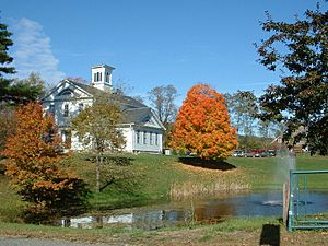
The former Powers Institute, now the town's Historical Society
|
||
|
||
| Nickname(s):
Falltown
|
||

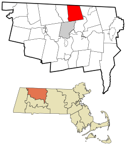
Location in Franklin County in Massachusetts
|
||
| Country | United States | |
| State | Massachusetts | |
| County | Franklin | |
| Settled | 1738 | |
| Incorporated | 1762 | |
| Government | ||
| • Type | Open town meeting | |
| Area | ||
| • Total | 23.4 sq mi (60.6 km2) | |
| • Land | 23.4 sq mi (60.6 km2) | |
| • Water | 0 sq mi (0.0 km2) | |
| Elevation | 374 ft (114 m) | |
| Population
(2020)
|
||
| • Total | 2,102 | |
| • Density | 89.84/sq mi (34.69/km2) | |
| Time zone | UTC−5 (Eastern) | |
| • Summer (DST) | UTC−4 (Eastern) | |
| ZIP Code |
01337
|
|
| Area code(s) | 413 | |
| FIPS code | 25-05560 | |
| GNIS feature ID | 0619378 | |
Bernardston is a small town in Franklin County, Massachusetts, United States. It is a part of the greater Springfield area. In 2020, about 2,102 people lived here.
Contents
Discover Bernardston's Past
Early Settlement: Falls Fight Township
Bernardston was first called Falls Fight Township. It was a frontier settlement. This means it was on the edge of settled lands. It was created for the families of soldiers. These soldiers fought in King Phillips War. This war was a big conflict in 1676. One important battle was the Battle of Turner's Falls.
In 1734, soldiers asked for land. They wanted a place to build a town. The court agreed, and 60 families were invited to settle. The first four houses were built in 1738. They were made of strong logs. They even had small holes for defense.
Frontier Defenses and Brave Settlers
Life on the frontier was tough. Major John Burke built a strong fort. It was about 100 feet on each side. Its walls were 12 feet high. People would go inside the fort every night. This kept them safe from attacks. The fort protected the settlement during conflicts. These included attacks starting in 1745. It also helped during the French and Indian War.
In 1746, a large group attacked the fort. Only two men were inside with Major Burke. But they fought bravely and drove the attackers away. Around the same time, Deacon Ebenezer Sheldon's house was attacked. His father, Lieutenant Ebenezer Sheldon, arrived just in time. He helped to chase the attackers off. Lieutenant Sheldon was known as the "Old Indian-Hunter." He was famous for his fighting skills.
In 1747, Eliakim Sheldon was shot. He was Lieutenant Ebenezer Sheldon's son. This happened near his father's house.
How Bernardston Got Its Name
Bernardston was once part of Colrain. It became its own town in 1762. Later, Leyden separated from Bernardston in 1784. The town is named after Governor Francis Bernard. He was the royal governor when the town was formed. Old maps show it as 'Bernard's Town'.
For many years, Bernardston was a farming town. Farmers grew rye and corn. They also made cider and maple syrup. It was one of the first places to make maple syrup. The town is also famous for a huge ox. This ox weighed 2,473 pounds! It was nicknamed "Constitution" or "Hero." It was the largest animal ever sent to the New York meat markets.
Bernardston's Geography
Location and Natural Features
Bernardston is in Franklin County. It is located in the northern part of Massachusetts. It borders Windham County, Vermont. The town covers about 23.4 square miles (60.6 square kilometers) of land.
Bernardston is part of the Pioneer Valley. It sits near the Pocumtuck Range. You can find several mountains here. These include Wildcat Mountain and Bald Mountain. The Fall River flows through the town. This river is a branch of the nearby Connecticut River. Other small streams also run through Bernardston. Part of the Satan's Kingdom Wildlife Management Area is also in town.
Roads and Transportation
Major roads run through Bernardston. These include Interstate 91 and U.S. Route 5. Both roads go north from Greenfield into Vermont. Bernardston is the last town in Massachusetts on these routes. Massachusetts Route 10 also passes through. It heads east towards the Connecticut River.
A railway line also runs through the town. It follows the path of Route 10. For bus service, people go to Greenfield. The closest small airport is in Montague. The nearest Amtrak train station is in Greenfield. For national flights, people use Bradley International Airport. This airport is in Windsor Locks, Connecticut.
Bernardston's Population Over Time
| Historical population | ||
|---|---|---|
| Year | Pop. | ±% |
| 1840 | 924 | — |
| 1850 | 937 | +1.4% |
| 1860 | 968 | +3.3% |
| 1870 | 961 | −0.7% |
| 1880 | 934 | −2.8% |
| 1890 | 770 | −17.6% |
| 1900 | 792 | +2.9% |
| 1910 | 741 | −6.4% |
| 1920 | 769 | +3.8% |
| 1930 | 893 | +16.1% |
| 1940 | 954 | +6.8% |
| 1950 | 1,117 | +17.1% |
| 1960 | 1,370 | +22.6% |
| 1970 | 1,659 | +21.1% |
| 1980 | 1,750 | +5.5% |
| 1990 | 2,048 | +17.0% |
| 2000 | 2,155 | +5.2% |
| 2010 | 2,129 | −1.2% |
| 2020 | 2,102 | −1.3% |
| 2022 | 2,104 | +0.1% |
Source: United States Census records and Population Estimates Program data. |
||
In 2000, Bernardston had 2,155 people. There were 848 households. Most people were White (99.03%). A small number were from other backgrounds. About 22.9% of the population was under 18 years old. The average age was 42 years.
Education in Bernardston
Local Schools
Bernardston is part of the Pioneer Valley Regional School District. This district includes several nearby towns. Each town has its own elementary school. Students in Bernardston go to Bernardston Elementary School. This school teaches children from pre-kindergarten to sixth grade.
After sixth grade, students attend Pioneer Valley Regional High School. This high school is located in Northfield. It serves students from seventh to twelfth grades. There is also a special school in town called The Full Circle School. It teaches students from preschool to sixth grade.
Higher Education Options
For college, the closest community college is Greenfield Community College. It is in Greenfield. The nearest state college is Westfield State College. The biggest state university is the University of Massachusetts Amherst. Many other colleges are also nearby. These are located in the Northampton–Amherst area.
Famous People from Bernardston
- Samuel Clesson Allen (1772–1842), a United States Congressman and minister.
- Lou Barlow, a musician in bands like Dinosaur Jr and Sebadoh.
- Bryant B. Brooks (1861–1944), a rancher and former Governor of Wyoming.
- Jean Brooks Greenleaf (1832–1918), a leader in the women's right to vote movement.
- Adam Harrington, a professional basketball player.
See also
 In Spanish: Bernardston (Massachusetts) para niños
 | Toni Morrison |
 | Barack Obama |
 | Martin Luther King Jr. |
 | Ralph Bunche |


