Colrain, Massachusetts facts for kids
Quick facts for kids
Colrain, Massachusetts
|
||
|---|---|---|

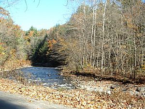
The Green River, flowing along the Colrain border
|
||
|
||

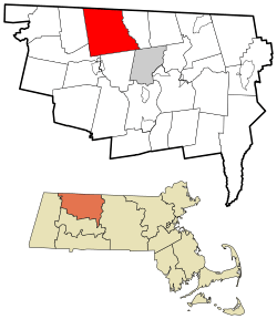
Location in Franklin County in Massachusetts
|
||
| Country | United States | |
| State | Massachusetts | |
| County | Franklin | |
| Settled | 1735 | |
| Incorporated | 1761 | |
| Government | ||
| • Type | Open town meeting | |
| Area | ||
| • Total | 43.4 sq mi (112.4 km2) | |
| • Land | 43.1 sq mi (111.7 km2) | |
| • Water | 0.3 sq mi (0.7 km2) | |
| Elevation | 902 ft (275 m) | |
| Population
(2020)
|
||
| • Total | 1,606 | |
| • Density | 37.006/sq mi (14.288/km2) | |
| Time zone | UTC-5 (Eastern) | |
| • Summer (DST) | UTC-4 (Eastern) | |
| ZIP Code |
01340
|
|
| Area code(s) | 413 | |
| FIPS code | 25-14885 | |
| GNIS feature ID | 0618160 | |
Colrain is a small town in Franklin County, Massachusetts, in the United States. In 2020, about 1,606 people lived there. Colrain is part of the larger Springfield area.
Contents
History of Colrain
Colrain was first settled in 1735. Back then, it was called "Boston Township No. 2." It became its own official town on June 30, 1761.
The town was named Colrain in 1745. For over 100 years, people often spelled it "Colraine." But in 1873, the state of Massachusetts said the town had to use its official spelling: Colrain.
Colrain has nine historic village areas. These include Elm Grove, Lyonsville, and Colrain City. Much of the town's land is outside these small villages.
Colrain City: A Funny Name
The town center, called Colrain City, got its name as a joke in the mid-1800s. It was a very small village, definitely not a big city! People joked that the houses were grouped there because folks couldn't make it up the hill. The center still looks much the same today. It was even named a historic district in 2006.
First Flag Over a School
In May 1812, Colrain made history. It was the first town in the United States to fly the U.S. flag over a public schoolhouse. This happened at the school in the village of Catamount.
The Missing Bell
Many of Colrain's first settlers came from Ireland and Scotland. It's believed the town was named after Lord Coleraine, an important person from Ireland. The story goes that Lord Coleraine was so happy about this, he sent a beautiful bell for the town's new meeting house.
Sadly, the bell never arrived! Some say the person trusted to deliver it sold it instead. That bell might have ended up in a church in Boston. Another story says the ship carrying the bell sank, and the bell was lost forever.
Forts and Protection
During a time called King George's War, Colrain was an important place for soldiers. The town had four forts: Fort Morrison, Fort Morris, Fort Lucas, and Rev. McDowell's Fort. These were strong, fenced-in houses used to protect people from attacks.
Soldiers from Massachusetts stayed at Forts Lucas and Morrison during the war. British soldiers might have used Fort Morrison too. After the war, the forts were used for local protection. When the Seven Years' War started in 1754, the forts were fixed up. Soldiers came back to Forts Lucas and Morrison. They stayed there for nine years. This made the townspeople a bit annoyed because they had to let soldiers stay in their homes.
After the French and Indian Wars ended in 1763, the soldiers left for good. The danger of attacks was much lower. By the late 1760s, the forts were no longer needed.
Geography of Colrain
Colrain covers about 112.4 square kilometers (43.4 square miles). Most of this is land, with a small amount of water. It is the second-largest town in Franklin County. Colrain is on the northern border of Massachusetts, next to Vermont.
The town is surrounded by other towns like Leyden to the east and Shelburne to the south. Colrain's town center is about 9 miles (14 km) northwest of Greenfield. It is about 100 miles (160 km) west of Boston.
Rivers and Forests
Colrain is in the northeastern part of the Berkshires, a mountain range. Many hills are divided by rivers that flow through the town. The Green River forms most of the town's eastern border. The east and west branches of the North River also meet here. Both rivers flow into the Deerfield River nearby.
The town also has two state forests: Catamount State Forest and part of the H.O. Cook State Forest. These are great places for nature and outdoor activities.
Getting Around
The main road in Colrain is Massachusetts Route 112. This road goes all the way to the Vermont state line. It's a popular route for people going skiing at Mount Snow, Vermont. The road follows the North River south.
The closest major highway, Interstate 91, is in Greenfield. There are no train, bus, or airport services directly in Colrain. You can find bus and train services in Greenfield. For bigger flights, the nearest airport is Bradley International Airport in Windsor Locks, Connecticut.
Climate
In Colrain, temperatures are usually below 50 degrees Fahrenheit (10 degrees Celsius) for about 205 days each year. The town gets about 49 inches (124 cm) of rain each year. Snow covers the ground for about 80 days, which is about 22% of the year. The air is not too humid, with humidity below 60% for about 18 days a year.
Population Changes
| Historical population | ||
|---|---|---|
| Year | Pop. | ±% |
| 1840 | 1,726 | — |
| 1850 | 1,785 | +3.4% |
| 1860 | 1,798 | +0.7% |
| 1870 | 1,742 | −3.1% |
| 1880 | 1,777 | +2.0% |
| 1890 | 1,671 | −6.0% |
| 1900 | 1,749 | +4.7% |
| 1910 | 1,741 | −0.5% |
| 1920 | 1,607 | −7.7% |
| 1930 | 1,391 | −13.4% |
| 1940 | 1,497 | +7.6% |
| 1950 | 1,546 | +3.3% |
| 1960 | 1,426 | −7.8% |
| 1970 | 1,420 | −0.4% |
| 1980 | 1,552 | +9.3% |
| 1990 | 1,757 | +13.2% |
| 2000 | 1,813 | +3.2% |
| 2010 | 1,671 | −7.8% |
| 2020 | 1,606 | −3.9% |
| 2023 | 1,629 | +1.4% |
Source: United States Census records and Population Estimates Program data. |
||
In 2000, Colrain had 1,813 people living there. About 33.7% of households had children under 18. The average age of people in Colrain was 38 years old.
Education
Colrain is part of the Mohawk Trail Regional School District. This district serves several towns. Younger students, from pre-kindergarten to sixth grade, go to Colrain Central School. Students in grades 7-12 attend Mohawk Trail Regional High School in Buckland.
There are also private schools nearby, like the Academy at Charlemont. For college, Greenfield Community College is in Greenfield. The nearest state university is the University of Massachusetts Amherst.
Notable people
Many interesting people have connections to Colrain:
- William Apess, a writer and activist from the Pequot tribe.
- Joseph Denison, the first President of Kansas State University. He was also an abolitionist, meaning he worked to end slavery.
- Almira Edson, a talented watercolor artist.
- Lorenzo Lyons, a missionary who traveled to the Kingdom of Hawaii.
- Elizabeth Perkins, a well-known actress.
- Samuel Taggart, a minister and U.S. congressman.
See also
 In Spanish: Colrain (Massachusetts) para niños
 | Stephanie Wilson |
 | Charles Bolden |
 | Ronald McNair |
 | Frederick D. Gregory |


