Springfield metropolitan area, Massachusetts facts for kids
Quick facts for kids
Springfield Metropolitan Area
|
|
|---|---|

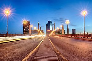
Springfield Metro Center from the Hampden County Memorial Bridge at blue hour
|
|
| Country | |
| State | |
| Principal municipalities |
Springfield |
| Area | |
| • Total | 1,904 sq mi (4,930 km2) |
| Population | |
| • Density | 367.9/sq mi (142.0/km2) |
| • MSA (2020) | 465,825(117th) |
| • CSA (2020) | 699,162(74th) |
| GDP | |
| • Total | $40.110 billion (2022) |
| Time zone | UTC-5 (Eastern Time Zone) |
| Area code(s) | 413 |
The Springfield metropolitan area, also known as Greater Springfield, is a large region in Western Massachusetts. It includes the city of Springfield, Massachusetts and many towns around it. People in this area share a similar way of life and culture.
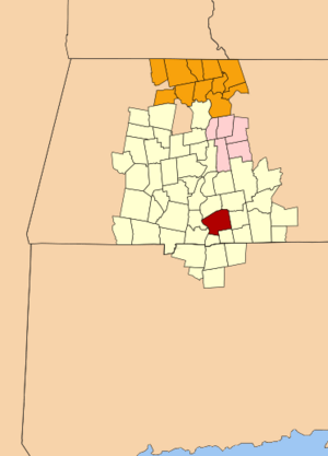
The U.S. government uses special terms to define these areas. The Springfield, MA Metropolitan Statistical Area (MSA) includes three counties in Western Massachusetts. In 2023, about 460,291 people lived here. This makes it the 117th largest metropolitan area in the United States.
Greater Springfield is one of two Combined Statistical Areas (CSAs) in Massachusetts. A CSA is an even larger area that connects several nearby metropolitan areas. The other CSA in Massachusetts is Greater Boston.
In New England, counties are not as important for local government as they are in other parts of the U.S. Instead, towns and cities are very important. Because of this, a different way to measure metropolitan areas was created. It's called the New England city and town area (NECTA). This system uses towns and cities as building blocks, which works better for New England. For example, the Springfield NECTA includes 51 cities and towns, even some in Connecticut.
Contents
Counties in the Springfield Area
The Springfield Metropolitan Statistical Area (MSA) includes these three counties:
Cities and Towns in the NECTA
The Springfield NECTA includes many cities and towns. These are located in Massachusetts and Connecticut.
- Agawam
- Amherst
- Ashfield
- Belchertown
- Blandford
- Chester
- Chesterfield
- Chicopee
- Conway
- Cummington
- Deerfield
- East Longmeadow
- East Windsor, Connecticut
- Easthampton
- Enfield, Connecticut
- Goshen
- Granby
- Granville
- Hadley
- Hampden
- Hatfield
- Holyoke
- Huntington
- Leverett
- Longmeadow
- Ludlow
- Monson
- Montgomery
- Northampton
- Palmer
- Pelham
- Russell
- Shutesbury
- Somers, Connecticut
- South Hadley
- Southampton
- Southwick
- Springfield (principal city)
- Suffield, Connecticut
- Sunderland
- Tolland
- Wales
- Ware
- Wendell
- West Springfield
- Westfield
- Westhampton
- Whately
- Wilbraham
- Williamsburg
- Windsor Locks, Connecticut
- Worthington
People in the Area
The population of the Springfield metropolitan area is very diverse. In 2010, about 692,942 people lived here. Most people were White, but there were also many African American, Asian, and Native American residents. A large number of people in the area are of Hispanic or Latino background.
In fact, in 2010, the Springfield metropolitan area had the highest percentage of Puerto Ricans of any major metropolitan area in the continental United States. This shows the rich mix of cultures in the region.
Getting Around: Transportation
The main way people get around using public transport in the Springfield area is through the Pioneer Valley Transit Authority (PVTA). This organization runs buses and vans. It is the largest regional public transport system in Massachusetts.
The PVTA started in 1974. It serves 24 towns and cities in Hampden, Hampshire, and Franklin counties. Each town helps pay for the service based on how many miles of routes are in their area. The PVTA also gets money from the U.S. federal and state governments.
News and Media
The Springfield-Holyoke area has its own local TV and radio stations. Nielsen, a company that measures TV viewership, ranks this area as the 111th largest TV market in the U.S.
Local news is provided by a few main groups. WWLP 22 is the local NBC channel. WesternMassNews combines the CBS channel WSHM 3 and the ABC/FOX channel WGGB. For public media, the local NPR radio station WFCR and PBS TV station WGBY joined together in 2019 to form New England Public Media.
See also
 In Spanish: Área metropolitana de Springfield (Massachusetts) para niños
 | Jackie Robinson |
 | Jack Johnson |
 | Althea Gibson |
 | Arthur Ashe |
 | Muhammad Ali |


