Chesterfield, Massachusetts facts for kids
Quick facts for kids
Chesterfield, Massachusetts
|
|||
|---|---|---|---|

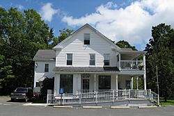
Chesterfield Post Office
|
|||
|
|||

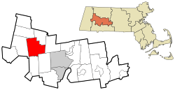
Location in Hampshire County in Massachusetts
|
|||
| Country | United States | ||
| State | Massachusetts | ||
| County | Hampshire | ||
| Settled | 1760 | ||
| Incorporated | 1762 | ||
| Government | |||
| • Type | Open town meeting | ||
| Area | |||
| • Total | 31.2 sq mi (80.9 km2) | ||
| • Land | 30.8 sq mi (79.9 km2) | ||
| • Water | 0.4 sq mi (1.0 km2) | ||
| Elevation | 1,394 ft (425 m) | ||
| Population
(2020)
|
|||
| • Total | 1,186 | ||
| • Density | 37.97/sq mi (14.660/km2) | ||
| Time zone | UTC−5 (Eastern) | ||
| • Summer (DST) | UTC−4 (Eastern) | ||
| ZIP Code |
01012
|
||
| Area code(s) | 413 | ||
| FIPS code | 25-13590 | ||
| GNIS feature ID | 0618197 | ||
Chesterfield is a small, quiet town in Hampshire County, Massachusetts, United States. It's located in a hilly area known as the "Hilltowns" of Western Massachusetts. The town is about 26 miles (42 km) east of Pittsfield and 90 miles (145 km) west of Boston. In 2020, about 1,186 people lived there. Chesterfield is part of the larger Springfield Metropolitan Statistical Area.
Contents
History of Chesterfield
Chesterfield was first settled by people in 1760. It officially became a town in 1762. The town was named after the Earl of Chesterfield, a famous person from England.
Early Days and Farming
After the American Revolution, the town center was built. You can still see many old houses from the Federal period (a time after the Revolution) along Main Road. In its early years, Chesterfield was mostly a farming town. Farmers raised Merino sheep, and their wool was a very important product.
Growth of Industry
Besides farming, there were also sawmills that cut wood and tanneries that made leather. Mills that processed cloth also opened. In the early 1800s, these industries grew more important than farming. This growth brought a small number of new people to the town, mostly Irish immigrants, who came to work in the mills.
Modern Chesterfield
Over time, most of these industries closed down. By the early 1900s, farming became important again. Also, many people started visiting Chesterfield for their summer vacations, which helped the town's economy.
Geography of Chesterfield
Chesterfield covers a total area of about 31.2 square miles (80.9 square kilometers). Most of this area is land, with a small part being water.
Location in Massachusetts
Chesterfield is located in the "Hilltowns" region of Massachusetts. It is almost in the middle of the state, if you look at the northern, southern, and western borders.
Distances to Cities
The town is about 52 miles (84 km) north of Hartford, Connecticut. It's 108 miles (174 km) west of Boston and 30 miles (48 km) northwest of Springfield. Other nearby cities include Albany, New York (64 miles or 103 km southeast) and New York City (160 miles or 257 km northeast).
Education in Chesterfield
Students in Chesterfield are part of the Hampshire Regional School District. This district also includes the towns of Goshen, Southampton, Westhampton, and Williamsburg.
Local Schools
Younger students, from kindergarten to 6th grade, attend New Hingham Regional Elementary School. They go to this school with students from Goshen. For older students, from 7th to 12th grade, they attend Hampshire Regional High School.
Points of Interest
Chesterfield has a few interesting places to visit.
- Chesterfield Gorge: This is a beautiful natural area along the Westfield River. It is managed by the Trustees of Reservations, a group that protects special places.
- Indian Hollow (Massachusetts): Another natural spot in the area.
Population of Chesterfield
| Historical population | ||
|---|---|---|
| Year | Pop. | ±% |
| 1790 | 1,183 | — |
| 1820 | 1,447 | +22.3% |
| 1850 | 1,014 | −29.9% |
| 1860 | 897 | −11.5% |
| 1870 | 811 | −9.6% |
| 1880 | 769 | −5.2% |
| 1890 | 608 | −20.9% |
| 1900 | 611 | +0.5% |
| 1910 | 536 | −12.3% |
| 1920 | 441 | −17.7% |
| 1930 | 420 | −4.8% |
| 1940 | 422 | +0.5% |
| 1950 | 496 | +17.5% |
| 1960 | 556 | +12.1% |
| 1970 | 704 | +26.6% |
| 1980 | 1,000 | +42.0% |
| 1990 | 1,048 | +4.8% |
| 2000 | 1,201 | +14.6% |
| 2010 | 1,222 | +1.7% |
| 2020 | 1,186 | −2.9% |
| 2022* | 1,175 | −0.9% |
| * = population estimate. | ||
In 2000, there were 1,201 people living in Chesterfield. These people made up 447 households and 324 families. The town had about 38.6 people per square mile (14.9 people per square kilometer).
Households and Families
Out of the 447 households, about 34% had children under 18 living with them. Most households (60.6%) were married couples living together. About 18.8% of households were made up of people living alone. About 6.5% of these were people aged 65 or older living by themselves. The average household had about 2.69 people. The average family had about 3.09 people.
See also
 In Spanish: Chesterfield (Massachusetts) para niños
 | Frances Mary Albrier |
 | Whitney Young |
 | Muhammad Ali |


