Westhampton, Massachusetts facts for kids
Quick facts for kids
Westhampton, Massachusetts
|
|||
|---|---|---|---|

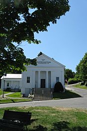
Westhampton Town Hall
|
|||
|
|||

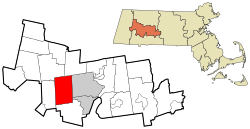
Location in Hampshire County in Massachusetts
|
|||
| Country | United States | ||
| State | Massachusetts | ||
| County | Hampshire | ||
| Settled | 1762 | ||
| Incorporated | 1778 | ||
| Government | |||
| • Type | Open town meeting | ||
| Area | |||
| • Total | 27.4 sq mi (70.9 km2) | ||
| • Land | 27.2 sq mi (70.4 km2) | ||
| • Water | 0.2 sq mi (0.5 km2) | ||
| Elevation | 730 ft (223 m) | ||
| Population
(2020)
|
|||
| • Total | 1,622 | ||
| • Density | 59.25/sq mi (22.877/km2) | ||
| Time zone | UTC-5 (Eastern) | ||
| • Summer (DST) | UTC-4 (Eastern) | ||
| ZIP Code |
01027
|
||
| Area code(s) | 413 | ||
| FIPS code | 25-76380 | ||
| GNIS feature ID | 0618210 | ||
Westhampton is a small town located in Hampshire County, Massachusetts, United States. In 2020, about 1,622 people lived there. It is part of the larger Springfield Metropolitan Area.
Contents
History of Westhampton
Westhampton was first settled by people in 1762. It was originally part of the nearby town of Northampton. Westhampton officially became its own town on September 29, 1778.
The first town meeting was held on November 19, 1778. At this meeting, Reverend Enoch Hale was chosen as the town's first minister. Enoch Hale was the brother of Nathan Hale, a famous American spy during the American Revolutionary War.
Westhampton is also home to the Hampshire Regional High School. This school serves students from five different towns: Westhampton, Southampton, Williamsburg, Goshen, and Chesterfield.
Geography of Westhampton
Westhampton covers a total area of about 70.9 square kilometers (27.4 square miles). Most of this area is land, about 70.4 square kilometers (27.2 square miles). A small part, about 0.5 square kilometers (0.2 square miles), is water.
The town shares its borders with several other towns. To the south is Southampton. To the west is Huntington. Chesterfield is to the northwest, and Williamsburg is to the northeast. To the east is Northampton, and to the southeast is Easthampton.
Massachusetts Route 66 is the only state highway that goes through Westhampton. This road leads east about 9 miles (14 km) to Northampton. It also goes west about 5 miles (8 km) to Knightville, which is in the town of Huntington.
Population and People
| Historical population | ||
|---|---|---|
| Year | Pop. | ±% |
| 1850 | 602 | — |
| 1860 | 608 | +1.0% |
| 1870 | 587 | −3.5% |
| 1880 | 563 | −4.1% |
| 1890 | 477 | −15.3% |
| 1900 | 469 | −1.7% |
| 1910 | 423 | −9.8% |
| 1920 | 305 | −27.9% |
| 1930 | 374 | +22.6% |
| 1940 | 403 | +7.8% |
| 1950 | 452 | +12.2% |
| 1960 | 583 | +29.0% |
| 1970 | 793 | +36.0% |
| 1980 | 1,137 | +43.4% |
| 1990 | 1,327 | +16.7% |
| 2000 | 1,468 | +10.6% |
| 2010 | 1,607 | +9.5% |
| 2020 | 1,622 | +0.9% |
| 2022* | 1,620 | −0.1% |
| * = population estimate. Source: United States Census records and Population Estimates Program data. | ||
According to the 2000 census, there were 1,468 people living in Westhampton. These people lived in 542 households. About 422 of these households were families.
Many households had children under 18 living with them (34.3%). Most households (69.0%) were married couples living together. About 15.9% of all households were made up of people living alone.
The population was spread out by age. About 25.4% of the people were under 18 years old. About 9.2% were 65 years or older. The average age in the town was 40 years.
Notable People from Westhampton
- Otis Clapp: He was a politician who served as a state representative in Massachusetts. He was also a member of the Boston City Council. Besides politics, he was a homeopath, pharmacist, and publisher.
- Adam Dutkiewicz: He is a guitarist for the metalcore band Killswitch Engage.
- Mordicai Gerstein: He was a well-known illustrator of children's books.
- Sylvester Judd: He was an author known for his 1845 book Margaret. He was also friends with famous writers like Ralph Waldo Emerson.
See also
 In Spanish: Westhampton (Massachusetts) para niños
 | Valerie Thomas |
 | Frederick McKinley Jones |
 | George Edward Alcorn Jr. |
 | Thomas Mensah |


