Sunderland, Massachusetts facts for kids
Quick facts for kids
Sunderland, Massachusetts
|
||
|---|---|---|
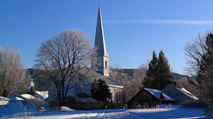
First Congregational of Sunderland, organized in 1718
|
||
|
||
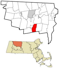
Location in Franklin County in Massachusetts
|
||
| Country | United States | |
| State | Massachusetts | |
| County | Franklin | |
| Settled | 1713 | |
| Incorporated | November 12, 1718 | |
| Government | ||
| • Type | Open town meeting | |
| Area | ||
| • Total | 14.7 sq mi (38.2 km2) | |
| • Land | 14.2 sq mi (36.9 km2) | |
| • Water | 0.5 sq mi (1.3 km2) | |
| Elevation | 748 ft (228 m) | |
| Population
(2020)
|
||
| • Total | 3,663 | |
| • Density | 248.4/sq mi (95.89/km2) | |
| Time zone | UTC-5 (Eastern) | |
| • Summer (DST) | UTC-4 (Eastern) | |
| ZIP Code |
01375
|
|
| Area code(s) | 413 | |
| FIPS code | 25-68400 | |
| GNIS feature ID | 0618176 | |
Sunderland is a town in Franklin County, Massachusetts, United States. It is part of the Pioneer Valley region. In 2020, about 3,663 people lived there.
Sunderland was first settled in 1713. It became an official town in 1718. The town was first called Swampfield. This name is still used for Swampfield Road. The name was changed to attract more people to live there. It was renamed after Charles Spencer, who was the Earl of Sunderland. For a long time, the land was mostly used for farming. Before 1774, the nearby town of Leverett was part of Sunderland.
Contents
Geography and Travel
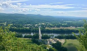
Sunderland covers about 38.2 square kilometers (14.7 square miles). Most of this area is land, with a small part being water. The town is located in the Pioneer Valley. It sits on the east side of the Connecticut River. This river helps drain water from the town.
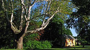
Mount Toby is a large mountain on the east side of Sunderland. It has a fire tower where you can see far away. The Robert Frost Trail, which is 47 miles long, goes through the mountain. Mount Toby State Forest surrounds the mountain. It is known for its waterfalls, beautiful views, and many different kinds of plants and animals. Sunderland is also home to the Buttonball Tree. This American sycamore tree is famous for being very large and old.
Sunderland is on the southern edge of Franklin County. It borders Montague to the north and Leverett to the east. To the south are Amherst and Hadley. To the west are Whately and Deerfield. You cannot drive directly from Sunderland to Whately because of the river.
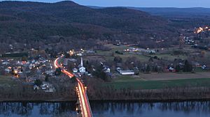
There are no major highways like interstates in Sunderland. The closest one is Interstate 91 to the west. Route 116 goes through Sunderland. It comes from Amherst and crosses the Connecticut River on the Sunderland Bridge into Deerfield. This bridge is the only road crossing over the Connecticut River for a long distance.
Route 47 also goes through the western part of town. It crosses Route 116. Route 63 passes through a small part of Sunderland in the northeast. The New England Central Railroad also runs through town near Route 63. There are bus services available in Sunderland. The Franklin Regional Transit Authority (FRTA) and Pioneer Valley Transit Authority (PVTA) both have routes here. For air travel, the closest small airport is Turners Falls Airport. The closest large airport is Bradley International Airport in Connecticut.
Population Information
| Historical population | ||
|---|---|---|
| Year | Pop. | ±% |
| 1790 | 462 | — |
| 1800 | 537 | +16.2% |
| 1810 | 551 | +2.6% |
| 1820 | 597 | +8.3% |
| 1830 | 666 | +11.6% |
| 1840 | 719 | +8.0% |
| 1850 | 792 | +10.2% |
| 1860 | 839 | +5.9% |
| 1870 | 832 | −0.8% |
| 1880 | 755 | −9.3% |
| 1890 | 663 | −12.2% |
| 1900 | 771 | +16.3% |
| 1910 | 1,047 | +35.8% |
| 1920 | 1,289 | +23.1% |
| 1930 | 1,159 | −10.1% |
| 1940 | 1,085 | −6.4% |
| 1950 | 905 | −16.6% |
| 1960 | 1,279 | +41.3% |
| 1970 | 2,236 | +74.8% |
| 1980 | 2,929 | +31.0% |
| 1990 | 3,399 | +16.0% |
| 2000 | 3,777 | +11.1% |
| 2010 | 3,684 | −2.5% |
| 2020 | 3,663 | −0.6% |
| 2022 | 3,647 | −0.4% |
Source: United States Census records and Population Estimates Program data. |
||
|
|
In 2000, there were 3,777 people living in Sunderland. There were 1,633 households. About 22.5% of households had children under 18. Many people lived alone or with roommates. The average household had 2.28 people.
Schools in Sunderland
Sunderland is part of the Frontier Regional and Union 38 School Districts. These districts also include Conway, Whately, and Deerfield. Each town has its own elementary school. Sunderland Elementary School teaches students from preschool to sixth grade.
Students from all four towns go to Frontier Regional School in Deerfield for grades seven through twelve. The sports teams at Frontier are called the Redhawks. Their team colors are red and blue. Frontier also has many art programs for students. There are also private schools in the area. These include the Bement School, Eaglebrook School, and Deerfield Academy.
Local Businesses
Sunderland has many businesses and restaurants. Most of them are located along Amherst Road (Route 116). Sunderland is also known for Mike's Maze Corn Maze, which is open seasonally.
Housing and Town Growth
Sunderland uses a program to protect farmland. This program buys the rights to develop farmland. This means farming can continue, but houses or stores cannot be built on that land. This helps keep the town's rural feel.
Sunderland has many rental homes. These homes are often rented by students from nearby colleges. These rentals are affordable for many people. Sunderland has more rental units per person than almost any other town in Massachusetts.
Fun Activities
The Sunderland Recreation Department offers many programs and events. In 2007, there were over 40 activities for residents. These include craft lessons and sports events. There are also hikes and dance lessons. The town holds annual fall festivals in October. There is also a Memorial Day parade and ceremony.
The Mount Toby state reservation is in Sunderland. It has many trails for hiking, mountain biking, and skiing. You can also go snowmobiling and hunting there. The Sunderland Boat Ramp on the Connecticut River is great for swimming, fishing, and boating.
See also
 In Spanish: Sunderland (Massachusetts) para niños
 | Delilah Pierce |
 | Gordon Parks |
 | Augusta Savage |
 | Charles Ethan Porter |


