Leverett, Massachusetts facts for kids
Quick facts for kids
Leverett, Massachusetts
|
|||
|---|---|---|---|

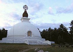
The New England Peace Pagoda in Leverett
|
|||
|
|||

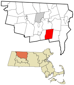
Location in Franklin County in Massachusetts
|
|||
| Country | United States | ||
| State | Massachusetts | ||
| County | Franklin | ||
| Settled | 1713 | ||
| Incorporated | 1774 | ||
| Government | |||
| • Type | Open town meeting | ||
| Area | |||
| • Total | 23.0 sq mi (59.5 km2) | ||
| • Land | 22.9 sq mi (59.2 km2) | ||
| • Water | 0.1 sq mi (0.4 km2) | ||
| Elevation | 883 ft (269 m) | ||
| Population
(2020)
|
|||
| • Total | 1,865 | ||
| • Density | 81.09/sq mi (31.34/km2) | ||
| Time zone | UTC−5 (Eastern) | ||
| • Summer (DST) | UTC−4 (Eastern) | ||
| ZIP Code |
01054 (shared with the North Amherst post office)
|
||
| Area code(s) | 413 | ||
| FIPS code | 25-35180 | ||
| GNIS feature ID | 0618168 | ||
Leverett is a small town in Franklin County, Massachusetts, in the United States. In 2020, about 1,865 people lived here. It is part of the larger Springfield area.
Contents
Leverett's Story: A Look Back
Leverett is one of the towns in the southern part of Franklin County. It is located near other towns like Shutesbury, Wendell, Sunderland, Montague, and Amherst. Leverett was once part of Sunderland, which was called Swampfield a long time ago.
The first European settlers arrived in 1750. In 1774, these settlers asked Sunderland to become their own separate town. The town was named after John Leverett, who was an important leader (Governor) of the Massachusetts Bay Colony a long time ago.
In 1985, a group of Buddhist monks from Nipponzan Myohoji built a special monument in Leverett. This building is called the New England Peace Pagoda. It was the first one of its kind in North America. There are also two old Christian churches in Leverett: North Leverett Baptist and Moore's Corner Church.
In 2005, a newspaper called The Boston Globe wrote that Leverett and its neighbor, Shutesbury, had slow internet. They called them "America's Broadband Black Holes." But in 2017, the Governor of Massachusetts, Charlie Baker, announced money to help bring fast internet to Leverett and other towns.
Where is Leverett?
Leverett covers about 23 square miles (59.5 square kilometers). Most of this area is land, with a small amount of water. The town is located where the Pioneer Valley meets the hills of northwestern Massachusetts. It is just east of the Connecticut River.
The southwestern part of Leverett is mostly flat. However, the rest of the town has many hills. The tallest hill is Brushy Mountain, which is about 1,260 feet (384 meters) high.
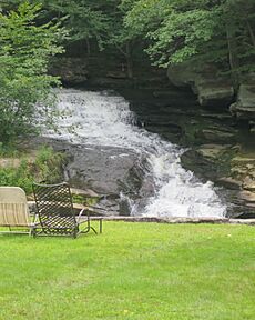
Many small streams flow through Leverett, all heading towards the Connecticut River. Leverett Pond is the biggest body of water in the town. A small part of Mount Toby State Forest is also in Leverett. The town's most famous natural spot is Rattlesnake Gutter. This is a deep, narrow valley filled with large rocks, located near the center of town.
Leverett is on the southern border of Franklin County, next to Hampshire County. It shares borders with Montague to the north, Wendell to the northeast, Shutesbury to the east, Amherst to the south, and Sunderland to the west. Leverett has four small villages: Leverett Center, East Leverett, North Leverett, and Moores Corner. North Leverett is in the northern part of town.
From Leverett Center, it is about 14 miles (23 km) south-southeast of Greenfield, which is the county seat. It is also about 27 miles (43 km) north of Springfield and 86 miles (138 km) west of Boston.
Who Lives in Leverett?
| Historical population | ||
|---|---|---|
| Year | Pop. | ±% |
| 1850 | 948 | — |
| 1860 | 964 | +1.7% |
| 1870 | 877 | −9.0% |
| 1880 | 742 | −15.4% |
| 1890 | 702 | −5.4% |
| 1900 | 744 | +6.0% |
| 1910 | 728 | −2.2% |
| 1920 | 695 | −4.5% |
| 1930 | 677 | −2.6% |
| 1940 | 688 | +1.6% |
| 1950 | 791 | +15.0% |
| 1960 | 914 | +15.5% |
| 1970 | 1,005 | +10.0% |
| 1980 | 1,471 | +46.4% |
| 1990 | 1,785 | +21.3% |
| 2000 | 1,663 | −6.8% |
| 2010 | 1,851 | +11.3% |
| 2020 | 1,865 | +0.8% |
| 2022 | 1,860 | −0.3% |
Source: United States Census records and Population Estimates Program data. |
||
In 2000, there were 1,663 people living in Leverett. These people lived in 632 homes, and 448 of these were families. The population density was about 73 people per square mile (28 people per square kilometer). Most people living in Leverett were White (95.31%).
About 34% of homes had children under 18. Most homes (58.5%) were married couples living together. The average home had about 2.58 people. The average family had about 2.92 people.
The median age of people in Leverett was 43 years old. About 23.3% of the population was under 18. About 11.2% of the population was 65 years or older.
Getting Around Leverett
There are no major highways that go through Leverett. The closest big highway, Interstate 91, is west of town, across the Connecticut River. The only state road that passes through Leverett is Route 63. It runs through the western part of town, connecting Amherst to Montague. This road runs next to a freight train line called the New England Central Railroad.
For air travel, the closest small airport is Turners Falls Airport in Montague. For bigger flights, the nearest major airport is Bradley International Airport in Connecticut.
Schools in Leverett
Leverett is part of a school group called Erving School Union #28 for students in grades PK–6 (pre-kindergarten through sixth grade). This group also includes the towns of Shutesbury, New Salem, Wendell, and Erving.
For older students, Leverett is part of the Amherst Regional School District. This district also includes Amherst, Pelham, and Shutesbury. Leverett has one elementary school for grades PK–6. After elementary school, students from Leverett go to Amherst Regional Middle School for grades 7–8. High school students attend Amherst Regional High School.
Famous People from Leverett
- Erastus Salisbury Field: A painter from the 1800s. His art can be seen in museums like Historic Deerfield and the National Gallery of Art in Washington D.C.
- Paula Green: The person who started the Karuna Center for Peacebuilding, which works to build peace.
- Michael Kittredge: The founder of the famous Yankee Candle Company.
See also
 In Spanish: Leverett (Massachusetts) para niños
 | Claudette Colvin |
 | Myrlie Evers-Williams |
 | Alberta Odell Jones |


