Pelham, Massachusetts facts for kids
Quick facts for kids
Pelham, Massachusetts
|
|||
|---|---|---|---|

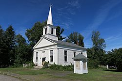
Pelham Hill Congregational Church
|
|||
|
|||
| Nickname(s):
The Town of Trees
|
|||

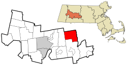
Location in Hampshire County in Massachusetts
|
|||
| Country | United States | ||
| State | Massachusetts | ||
| County | Hampshire | ||
| Settled | 1738 | ||
| Incorporated | 1743 | ||
| Government | |||
| • Type | Open town meeting | ||
| Area | |||
| • Total | 26.5 sq mi (68.6 km2) | ||
| • Land | 25.1 sq mi (64.9 km2) | ||
| • Water | 1.4 sq mi (3.7 km2) | ||
| Elevation | 1,146 ft (349 m) | ||
| Population
(2020)
|
|||
| • Total | 1,280 | ||
| • Density | 48.30/sq mi (18.66/km2) | ||
| Time zone | UTC−5 (Eastern) | ||
| • Summer (DST) | UTC−4 (Eastern) | ||
| ZIP Code |
01002 (shared with Amherst)
|
||
| Area code(s) | 413 | ||
| FIPS code | 25-52560 | ||
| GNIS feature ID | 0618205 | ||
| Website | www.townofpelham.org | ||
Pelham is a small town located in Hampshire County, Massachusetts, in the United States. In 2020, about 1,280 people lived there. Pelham shares its ZIP Code with the nearby town of Amherst.
Pelham is also part of the larger Springfield area, which is a group of cities and towns that are close to each other.
Contents
History of Pelham
Pelham was first settled in 1738 by people from Scotland and Ireland who were mostly Presbyterian. The town officially became a town in 1743. It was named after the Pelham family, especially Henry Pelham, who was the Prime Minister of the United Kingdom at that time.
Daniel Shays and the Rebellion
Pelham is famous for being the home of Daniel Shays. He led a series of protests called Shays' Rebellion in 1786 and 1787. These protests were by farmers who were unhappy with high taxes and debts in Massachusetts. The rebellion started in Conkey's Tavern in Pelham. Many towns in central and western Massachusetts supported it. The rebellion ended when the farmers' group refused to fight the governor's army and scattered in Petersham.
Pelham also has the oldest town hall in the United States that has been used continuously. A town meeting is held there every year.
Changes to Town Borders
Pelham's borders have changed twice. It used to be a much larger town, stretching east to Prescott Hill. However, some of its land was given to the town of Prescott in the late 1800s.
Later, when the Quabbin Reservoir was created, the landscape changed again. The reservoir covered parts of the Swift River. Some towns in the valley were dissolved, and a part of Enfield was added to Pelham. Because the reservoir separated Pelham from its old lands in Prescott, that land was given to New Salem instead.
The Warren Gibbs Story
On March 23, 1860, a young man named Warren Gibbs died in Pelham. His brother believed that Warren's wife, Mary Felton, was responsible. The brother had a tombstone made that said Mary had poisoned him. This caused the tombstone to be repeatedly damaged, and the brother had to hire guards to protect it.
Geography of Pelham
Pelham covers about 26.5 square miles (68.6 square kilometers). Most of this area is land, with about 1.4 square miles (3.7 square kilometers) being water. The town is on the western edge of the Quabbin Reservoir. Its border follows where the West Branch of the Swift River used to flow.
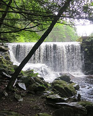
Pelham is located among hills that separate the Pioneer Valley to the west from the Quabbin Valley to the east. The streams in Pelham flow in both directions: some go towards the Quabbin Reservoir, and others flow towards the Connecticut River. The town has many forests, including Cadwell Memorial Forest, Buffam Falls Conservation Area, and the Quabbin lands.
Location and Nearby Towns
Pelham is the northeasternmost town in Hampshire County. It borders Franklin County to the north and east. It is bordered by Shutesbury to the north, New Salem to the east, Belchertown to the south, and Amherst to the west. Because of the Quabbin Reservoir, there is no direct road connection between Pelham and New Salem.
Pelham is about 14 miles (23 km) east of Northampton, which is the county seat. It is also about 25 miles (40 km) north-northeast of Springfield.
Getting Around Pelham
U.S. Route 202 runs through the eastern part of Pelham. This highway was rerouted because of the Quabbin Reservoir project. Besides a small part of Route 9 that touches the town's southwest corner, Route 202 is the main highway in Pelham.
Pelham is roughly the same distance from major highways like Interstate 90 (to the south), Interstate 91 (to the west), and Route 2 (to the north).
For train travel, the nearest Amtrak service is the Vermonter train in Northampton. There are small airports nearby for private planes. For national flights, the closest major airport is Bradley International Airport in Connecticut.
Education in Pelham
Pelham is part of the Amherst Regional School District. This district also includes the towns of Amherst, Leverett, and Shutesbury.
Pelham has one elementary school, the Pelham Elementary School, for students from kindergarten to fifth grade. After elementary school, students from Pelham attend Amherst Regional Middle School for grades six through eight. Then, they go to Amherst Regional High School for grades nine through twelve.
Population of Pelham
| Historical population | ||
|---|---|---|
| Year | Pop. | ±% |
| 1850 | 983 | — |
| 1860 | 748 | −23.9% |
| 1870 | 673 | −10.0% |
| 1880 | 614 | −8.8% |
| 1890 | 486 | −20.8% |
| 1900 | 462 | −4.9% |
| 1910 | 467 | +1.1% |
| 1920 | 503 | +7.7% |
| 1930 | 455 | −9.5% |
| 1940 | 568 | +24.8% |
| 1950 | 579 | +1.9% |
| 1960 | 805 | +39.0% |
| 1970 | 937 | +16.4% |
| 1980 | 1,112 | +18.7% |
| 1990 | 1,373 | +23.5% |
| 2000 | 1,403 | +2.2% |
| 2010 | 1,321 | −5.8% |
| 2020 | 1,280 | −3.1% |
| 2022* | 1,266 | −1.1% |
| * = population estimate. Source: United States Census records and Population Estimates Program data. |
||
According to the 2000 US census, there were 1,403 people living in Pelham. These people lived in 545 households, and 382 of these were families. The average number of people in a household was about 2.57.
Most of the people living in Pelham were White (95.08%). There were also smaller percentages of African American (1.43%) and Asian (1.07%) residents. About 1.85% of the population identified as Hispanic or Latino.
The population was spread out by age:
- 23.2% were under 18 years old.
- 7.7% were between 18 and 24.
- 24.4% were between 25 and 44.
- 32.1% were between 45 and 64.
- 12.5% were 65 years or older.
The average age in Pelham was 42 years.
Notable People from Pelham
- Daniel Shays (1747–1825), a leader of Shays' Rebellion.
- Lettie S. Bigelow (1848/49–1906), an author.
- Deb Talan (born 1968), a singer-songwriter.
- H. W. Harkness (1821–1901), a scientist who studied fungi and nature.
See also
 In Spanish: Pelham (Massachusetts) para niños
 | William Lucy |
 | Charles Hayes |
 | Cleveland Robinson |


