
Shutesbury, Massachusetts facts for kids
Quick facts for kids
Shutesbury, Massachusetts
|
||
|---|---|---|

Community Church, Shutesbury MA
|
||
|
||
 |
||
| Country | United States | |
| State | Massachusetts | |
| County | Franklin | |
| Settled | 1735 | |
| Incorporated | 1761 | |
| Government | ||
| • Type | Open town meeting | |
| Area | ||
| • Total | 27.2 sq mi (70.4 km2) | |
| • Land | 26.6 sq mi (68.9 km2) | |
| • Water | 0.6 sq mi (1.5 km2) | |
| Elevation | 1,096 ft (334 m) | |
| Population
(2020)
|
||
| • Total | 1,717 | |
| • Density | 63.13/sq mi (24.389/km2) | |
| Time zone | UTC−5 (Eastern) | |
| • Summer (DST) | UTC−4 (Eastern) | |
| ZIP Code |
01072
|
|
| Area code(s) | 413 | |
| FIPS code | 25-61905 | |
| GNIS feature ID | 0619382 | |

Shutesbury is a small town located in Franklin County, Massachusetts, in the United States. In 2020, about 1,717 people lived here. It is part of the larger Springfield metropolitan area, Massachusetts.
Contents
A Look Back: Shutesbury's History
For over 2,000 years, the area that is now Shutesbury was home to the Nipmuc people. They called parts of the land "Sanakkamak," which meant "difficult land." This was because of its many ponds, swamps, and streams, leading to steep mountains like Kunckquatchu (Mt. Toby). Other parts were called "Kingyiwngwalak," meaning "Upturned land," due to the tilted rocks and deep valleys.
The Nipmuc people used this land for hunting, fishing, and gathering wild foods like chestnuts and blueberries. When they made agreements with the first European settlers, they made sure to keep their right to hunt, fish, and collect wood from the land.
From Road Town to Shutesbury
European settlers arrived in 1735 and first called the area Road Town. This name came from their original request to Boston to build a road in this wild area. In 1761, Road Town officially became Shutesbury. The town was named after Samuel Shute, who used to be a governor.
Early settlers had to clear forests to make space for farming and grazing animals. Over time, much of the forest was cut down. However, after the Civil War, the area slowly grew back its forests. Today, protecting the remaining farmlands and forests is a big goal for the town.
Recent Times and Community Life
In December 2008, a major ice storm hit Massachusetts. Shutesbury was badly affected, with ice covering trees and causing power outages for up to ten days. The National Guard even came to help with the cleanup.
Shutesbury is known for its quiet, rural feel. Many residents choose to live here because they love nature and work to keep the town's natural beauty. One unique thing about Shutesbury is that it has no street lights, which means you can see the stars clearly at night! A large part of the town is protected as part of the Quabbin Reservation and Shutesbury State Forest.
For a while, Shutesbury had slow internet, but in 2017, the state helped bring high-speed internet to the town. The Shutesbury Town Library is also special. Besides books, you can borrow kayaks, life vests, and paddles to use at Lake Wyola! The library building itself is quite old, built in 1902, and is very small.
Exploring Shutesbury's Geography
Shutesbury covers about 27.2 square miles (70.4 square kilometers). Most of this is land, with a small amount of water. The town is located at the northern end of the western part of the Quabbin Reservoir, a large body of water. The West Branch of the Swift River flows through the town into the reservoir.
In the northwestern part of Shutesbury, you'll find Lake Wyola, which has wetlands on its eastern side. The center of town has a high ridge, and the southwestern part slopes down towards the Connecticut River. Part of the eastern hills are protected as the Shutesbury State Forest.
Shutesbury is on the southern edge of Franklin County. It shares borders with several other towns: Wendell to the north, New Salem to the east, Pelham to the south, Amherst to the southwest, and Leverett to the west. The town center is about 17 miles (27 km) southeast of Greenfield, the county seat.
Getting Around: Transportation
Shutesbury does not have any major highways or expressways passing through it. The closest major highway is Interstate 91 to the west. U.S. Route 202, also known as the Daniel Shays Highway, runs along the eastern edge of the town.
There is no public transportation like buses or trains within Shutesbury itself. The closest train tracks for freight are in nearby Leverett and Amherst. For passenger trains, the Amtrak Vermonter line can be found in Northampton.
If you need to fly, the closest small airports are in Montague and Orange. For bigger flights, the nearest major airport is Bradley International Airport in Connecticut.
Learning in Shutesbury: Education
Shutesbury is part of the Amherst Regional School District. This district also includes the towns of Amherst, Leverett, and Pelham.
Children in Shutesbury attend Shutesbury Elementary School for kindergarten through sixth grade. After elementary school, students go to Amherst Regional Middle School for seventh and eighth grades. For high school, students attend Amherst Regional High School.
People of Shutesbury: Demographics
| Historical population | ||
|---|---|---|
| Year | Pop. | ±% |
| 1840 | 997 | — |
| 1850 | 912 | −8.5% |
| 1860 | 798 | −12.5% |
| 1870 | 614 | −23.1% |
| 1880 | 529 | −13.8% |
| 1890 | 453 | −14.4% |
| 1900 | 382 | −15.7% |
| 1910 | 267 | −30.1% |
| 1920 | 242 | −9.4% |
| 1930 | 222 | −8.3% |
| 1940 | 191 | −14.0% |
| 1950 | 213 | +11.5% |
| 1960 | 265 | +24.4% |
| 1970 | 489 | +84.5% |
| 1980 | 1,049 | +114.5% |
| 1990 | 1,561 | +48.8% |
| 2000 | 1,810 | +16.0% |
| 2010 | 1,771 | −2.2% |
| 2020 | 1,717 | −3.0% |
| 2022 | 1,726 | +0.5% |
Source: United States Census records and Population Estimates Program data. |
||
In 2000, there were 1,810 people living in Shutesbury. About 44.1% of households had children under 18. Most households (61.3%) were married couples. The average household had 2.72 people.
The population was spread out by age:
- 28.6% were under 18
- 5.9% were 18 to 24
- 29.0% were 25 to 44
- 30.8% were 45 to 64
- 5.7% were 65 or older
The average age in town was 39 years. The median income for a household was about $60,438. Only a small number of families (1.0%) and people (3.8%) lived below the poverty line.
Places to Visit: Points of Interest
- Lake Wyola State Park: A great place for outdoor activities.
- Morse Hill Outdoor Education Center: Offers educational programs in nature.
- Pine Brook Camp and Conference Center: A place for camps and events.
- Temenos Retreat Center: A quiet place for reflection.
- Shutesbury Athletic Club: Despite its name, it's the only bar in Shutesbury.
- Sirius Community: An intentional community founded in 1978.
Images for kids
-
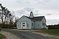
Shutesbury Town Hall
-
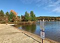
Public beach at Lake Wyola State Park
-
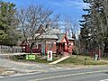
M.N. Spear Memorial Library
-
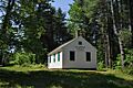
West Schoolhouse No. 2


See also
 In Spanish: Shutesbury para niños
