Wendell, Massachusetts facts for kids
Quick facts for kids
Wendell, Massachusetts
|
|||
|---|---|---|---|

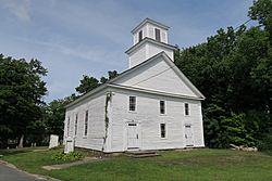
Wendell Meetinghouse
|
|||
|
|||

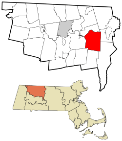
Location in Franklin County in Massachusetts
|
|||
| Country | United States | ||
| State | Massachusetts | ||
| County | Franklin | ||
| Settled | 1754 | ||
| Incorporated | 1781 | ||
| Government | |||
| • Type | Open town meeting | ||
| Area | |||
| • Total | 32.2 sq mi (83.4 km2) | ||
| • Land | 31.9 sq mi (82.5 km2) | ||
| • Water | 0.4 sq mi (1.0 km2) | ||
| Elevation | 1,037 ft (316 m) | ||
| Population
(2020)
|
|||
| • Total | 924 | ||
| • Density | 28.69/sq mi (11.079/km2) | ||
| Time zone | UTC−5 (Eastern) | ||
| • Summer (DST) | UTC−4 (Eastern) | ||
| ZIP Code |
01379
|
||
| Area code(s) | 351/978 | ||
| FIPS code | 25-74525 | ||
| GNIS feature ID | 0618178 | ||
Wendell is a small town in Franklin County, Massachusetts, USA. In 2020, about 924 people lived there. It is part of the larger Springfield area.
Contents
History of Wendell
People first settled in Wendell in 1754. It officially became a town in 1781. The town was named after Judge Oliver Wendell from Boston. The center of town is a historic district. It is listed on the National Register of Historic Places.
On July 11, 2006, a strong F2 tornado hit Wendell. It started near Wickett Pond and traveled about 2.9 miles. The tornado was 100 to 300 yards wide. It knocked down many trees, including an old maple tree. This falling tree damaged old gravestones in a historic cemetery. Even though trees fell and some buildings were damaged, no one was hurt.
Geography and Location
Wendell covers about 83.4 square kilometers (32.2 square miles). Most of this area, 82.5 square kilometers (31.9 square miles), is land. About 1.0 square kilometer (0.4 square miles) is water.
The town has two post offices. One is on Lockes Village Road, south of the town center. Its ZIP Code is 01379. The other is called "Wendell Depot" and has ZIP Code 01380. This name comes from the old train station that used to be there.
Exploring Wendell State Forest
Wendell State Forest is south of the Millers River. It covers 7,566 acres of hills, streams, ponds, and trails. This area was bought in the 1920s after many fires in the early 1900s. The Civilian Conservation Corps helped build roads and other parts of the park in the 1930s.
Ruggles Pond is a popular spot for visitors. This 10-acre pond has clear water for swimming and fishing. You can also find picnic areas and a ball field with a pavilion nearby. There is a small boat ramp at the north end of Wickett Pond. The Metacomet-Monadnock Trail goes through the forest. It has a small shelter for hikers to use.
Education in Wendell
Students in Wendell go to Swift River Elementary School in New Salem for kindergarten through sixth grade. For middle and high school, students attend Ralph C. Mahar Regional High School in Orange. This school serves grades 7 through 12.
Population and People
| Historical population | ||
|---|---|---|
| Year | Pop. | ±% |
| 1840 | 844 | — |
| 1850 | 920 | +9.0% |
| 1860 | 704 | −23.5% |
| 1870 | 539 | −23.4% |
| 1880 | 465 | −13.7% |
| 1890 | 505 | +8.6% |
| 1900 | 492 | −2.6% |
| 1910 | 502 | +2.0% |
| 1920 | 346 | −31.1% |
| 1930 | 353 | +2.0% |
| 1940 | 391 | +10.8% |
| 1950 | 342 | −12.5% |
| 1960 | 292 | −14.6% |
| 1970 | 405 | +38.7% |
| 1980 | 694 | +71.4% |
| 1990 | 899 | +29.5% |
| 2000 | 986 | +9.7% |
| 2010 | 848 | −14.0% |
| 2020 | 924 | +9.0% |
| 2022 | 921 | −0.3% |
Source: United States Census records and Population Estimates Program data. |
||
In 2000, there were 986 people living in Wendell. There were 378 households and 224 families. The population density was about 30.8 people per square mile. Most residents, about 92.49%, were White. About 3.45% were African American, and 0.41% were Asian.
About 27% of households had children under 18. About 43.7% were married couples. The average household had 2.35 people. The average family had 2.88 people.
The median age in Wendell was 38 years old. About 25.7% of the population was under 18. About 30.6% were between 25 and 44 years old. The median income for a household was $43,846. For a family, it was $60,147.
See also
 In Spanish: Wendell (Massachusetts) para niños
 | Jessica Watkins |
 | Robert Henry Lawrence Jr. |
 | Mae Jemison |
 | Sian Proctor |
 | Guion Bluford |


