
Belchertown, Massachusetts facts for kids
Quick facts for kids
Belchertown, Massachusetts
|
|||
|---|---|---|---|

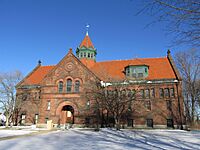
Belchertown Common
|
|||
|
|||
| Nicknames:
B-town, Cold Spring
|
|||

Location in Hampshire County in Massachusetts
|
|||
| Country | United States | ||
| State | Massachusetts | ||
| County | Hampshire | ||
| Settled | 1731 | ||
| Incorporated | 1761 | ||
| Government | |||
| • Type | Open town meeting | ||
| Area | |||
| • Total | 55.4 sq mi (143.4 km2) | ||
| • Land | 52.7 sq mi (136.6 km2) | ||
| • Water | 2.6 sq mi (6.8 km2) | ||
| Elevation | 613 ft (187 m) | ||
| Population
(2020)
|
|||
| • Total | 15,350 | ||
| • Density | 291.3/sq mi (112.4/km2) | ||
| Time zone | UTC−5 (Eastern) | ||
| • Summer (DST) | UTC−4 (Eastern) | ||
| ZIP Code |
01007
|
||
| Area code(s) | 413 | ||
| FIPS code | 25-04825 | ||
| GNIS feature ID | 0618196 | ||


Belchertown is a town in Hampshire County, Massachusetts, United States. It was once known as Cold Spring and Belcher's Town. This town is part of the Springfield area. In 2020, about 15,350 people lived here. Belchertown is also home to the census-designated place of Belchertown. A large area where the Belchertown State School used to be is now being developed for homes, shops, and fun activities. This includes the 385-acre Lampson Brook Farm. It is used for farming, outdoor fun, and protecting wildlife.
Contents
History of Belchertown
Early Days and Native People
The land where Belchertown is today was once a meeting point for Native American trails. These trails were used by groups like the Nipmuc and Norwottuck people. Old tools found in the early 1900s near Lake Metacomet show that Native Americans lived here about 7,000 years ago.
In 1716, some lands were sold by Connecticut Colony. These lands were given to people, including Jonathan Belcher. He later became the Royal Governor of Massachusetts.
Town's Founding and Name Changes
Belchertown was first settled in 1731. It officially became a town in 1761. Its first name was Cold Spring. Later, it was called Belcher's Town, and then finally Belchertown.
The town has several historic villages. These include Dwight's Station, Bardwell Village, Barrett's Junction, and Slab City.
Changes Due to Quabbin Reservoir
In 1816, parts of Belchertown and Greenwich, Massachusetts joined to form Enfield, Massachusetts. Later, in 1938, Enfield and Greenwich were two of four towns that were closed down. This happened to make space for the Quabbin Reservoir. A part of Enfield then became part of Belchertown again.
Belchertown State School and Local Government
The Belchertown State School was in town for over 70 years, from 1922 to 1994. It was a place for people with mental disabilities. After it closed, the land was planned for new homes, businesses, and farms.
Many people from Belchertown work at the University of Massachusetts. This university is in nearby Amherst.
Belchertown is run by a group called the select board. This board grew from three members to five in 1964. In 2019, its name changed from the Board of Selectmen to the Select Board.
Geography and Transportation
Land and Water Features
Belchertown covers about 55.4 square miles (143.4 km²). Most of this is land, about 52.7 square miles (136.6 km²). The rest, 2.6 square miles (6.8 km²), is water. The town is on the western side of the Quabbin Reservoir. The land around the reservoir is part of the Quabbin Reservation.
The northern part of Belchertown is hilly. These hills were once part of the Swift River Valley. The rest of the town has gentle slopes and many meadows. The Swift River forms the eastern border of the town. Along this river is the Herman Covey—Swift River Wildlife Management Area. Many other small streams and ponds are found in Belchertown. Some marshy areas are near the Broad Brook.
Neighboring Towns and Location
Belchertown is next to Franklin County, Massachusetts to the northeast. It also borders Hampden County, Massachusetts to the south. Other towns nearby are Pelham, Massachusetts to the north and Ware, Massachusetts to the east. To the southeast is Palmer, Massachusetts, and to the southwest is Ludlow, Massachusetts. Granby, Massachusetts and Amherst, Massachusetts are to the west. Belchertown does not touch New Salem directly, but their territories meet on the Quabbin Reservoir.
The center of Belchertown is about 14 miles (22 km) east of Northampton, Massachusetts. It is 18 miles (29 km) northeast of Springfield, Massachusetts. Worcester is about 37 miles (60 km) to the west. Boston is about 77 miles (124 km) west. Most people live around the town center. The rest of the town is mostly rural, with homes spread out. This is especially true near the smaller ponds, close to the villages of Dwight and North Station.
Roads and Railways
The closest major highway is Interstate 90. It runs just south of Belchertown. You can get on it from exits in Ludlow and Palmer. Massachusetts Route 21 leads to the Ludlow exit. Massachusetts Route 181 connects to the Palmer exit.
U.S. Route 202 also passes through Belchertown. It goes north along the edge of the reservoir towards Pelham. Massachusetts Route 9 is another important road. It goes east to west through central Massachusetts. Route 9 passes just north of the town center. You can reach Interstate 91 about nine miles from Belchertown using Route 9.
The New England Central Railroad runs through the town. This line carries freight. There is also a private airport, Metropolitan Airport, in Palmer. For national flights, the nearest airport is Bradley International Airport in Connecticut.
Population Information
| Historical population | ||
|---|---|---|
| Year | Pop. | ±% |
| 1850 | 2,680 | — |
| 1860 | 2,709 | +1.1% |
| 1870 | 2,428 | −10.4% |
| 1880 | 2,346 | −3.4% |
| 1890 | 2,120 | −9.6% |
| 1900 | 2,292 | +8.1% |
| 1910 | 2,054 | −10.4% |
| 1920 | 2,058 | +0.2% |
| 1930 | 3,139 | +52.5% |
| 1940 | 3,503 | +11.6% |
| 1950 | 4,487 | +28.1% |
| 1960 | 5,186 | +15.6% |
| 1970 | 5,936 | +14.5% |
| 1980 | 8,339 | +40.5% |
| 1990 | 10,579 | +26.9% |
| 2000 | 12,968 | +22.6% |
| 2010 | 14,649 | +13.0% |
| 2020 | 15,350 | +4.8% |
| 2022* | 15,316 | −0.2% |
| * = population estimate. Source: United States Census records and Population Estimates Program data. |
||
In 2000, Belchertown had 12,968 people living in 4,886 households. About 3,517 of these were families. The town had about 245.9 people per square mile (95.8 per km²). There were 5,050 homes.
Most people in Belchertown were White (96.14%). Other groups included Black (0.81%), Native American (0.19%), and Asian (0.96%). About 1.57% of the population was Hispanic or Latino.
Many households (38.8%) had children under 18. Most households (59.2%) were married couples. About 20.3% of households were single people. The average household had 2.65 people. The average family had 3.09 people.
The population was spread out by age. About 27.3% were under 18. About 33.3% were between 25 and 44. The average age was 36 years old. For every 100 females, there were about 94.9 males.
The average income for a household in Belchertown was $52,467. For a family, it was $60,830. The average income per person was $21,938. About 5.9% of the population lived below the poverty line. This included 6.1% of those under 18.
Education in Belchertown
History of Schools
In 1773, a group met to divide Belchertown into school districts. This happened after the American Revolution. In 1784, the town was split into seven school districts. By the 1800s, Belchertown had 18 schools!
Current School System
Today, the Belchertown School District has five schools:
- Cold Spring Elementary School (Pre-Kindergarten to Kindergarten)
- Swift River Elementary School (Grades 1–3)
- Chestnut Hill Community School (Grades 4–6)
- Jabish Middle School (Grades 7–8)
- Belchertown High School (Grades 9–12)
Fun Places to Visit
Belchertown has many interesting places to see and things to do:
- Belchertown Fair
- Belchertown Firefighters Museum
- Belchertown Skate Park
- Belchertown State School (now being redeveloped)
- Broad Brook Canal
- Clapp Memorial Library (a beautiful library built in 1887)
- Dwight (a historic village)
- Jessica's Boundless Playground
- Lake Metacomet
- Metacomet and Monadnock Trail (great for hiking)
- Mini Fenway Park
- Quabbin Reservoir (a large body of water)
- Robert Frost Hiking Trail
- Shelton Brothers Importers
- Skettersville Pond
- Stone House Museum
- Swift River
- Town Common
- Town Beach (at Lake Arcadia)
-
Clapp Memorial Library

Famous People from Belchertown
Many notable people have connections to Belchertown:
- Newell Snow Booth (1903–1968), a Methodist missionary, was born here.
- Elijah Coleman Bridgman (1801–1862), the first American Protestant missionary to China, was born here.
- Albert Levi Burt (1843–1913), who started the A. L. Burt book publishing company.
- Addison G. Foster (1837–1917), a US Senator, was born in Belchertown.
- Gregory Gillespie (1936–2000), a painter, died here.
- Joel Haver, a filmmaker and actor, grew up in Belchertown.
- Josiah Gilbert Holland (1819–1881), an author and poet, was born in Dwight.
- Raymond Kennedy (1934–2008), a novelist, spent his childhood here.
- Sara Tappan Doolittle Robinson (1827–1911), a writer and historian, was born and raised here. She was also the first First Lady of Kansas.
- Porter Rockwell (around 1813–1878), a bodyguard for Mormon leader Joseph Smith, was born in Belchertown.
- Mary F. Scranton, a missionary who founded Ewha Womans University in Korea.
- Ruth Sienkiewicz-Mercer (1950–1998), a disability rights activist, lived at the Belchertown State School.
- Ethan Smith (1762–1849), a clergyman and author, was born here.
- Clinton Edgar Woods (1863–around 1930), an engineer and inventor, was born here.
- Charles Warren Greene (1840 – 1920), a journalist and author, was born here.
See also
 In Spanish: Belchertown (Massachusetts) para niños
