
Mount Toby facts for kids
Quick facts for kids Mount Toby |
|
|---|---|

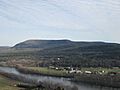
Mount Toby as seen from South Sugarloaf
|
|
| Highest point | |
| Elevation | 1,269 ft (387 m) |
| Prominence | 856 ft (261 m) |
| Geography | |
| Location | Sunderland and Leverett, Massachusetts Massachusetts, U.S. |
| Parent range | Associated with the Metacomet Ridge |
| Geology | |
| Age of rock | 190 million years |
| Mountain type | Fault-block; sedimentary |
| Climbing | |
| First ascent | Elnathan Toby (first reported) |
| Easiest route | Telephone Line Trail |
Mount Toby is a mountain in Massachusetts, U.S.. It stands about 1,269 feet (387 meters) tall. This mountain is the highest point in a group of wooded hills. These hills are located in the towns of Sunderland and Leverett, Massachusetts. Mount Toby is part of the Metacomet Ridge, a long line of hills and mountains. The mountain area is shaped like an oval, about three miles long and two miles wide. Even though some smaller peaks have their own names, people usually call the whole area "Mount Toby." This article will tell you more about this interesting mountain.
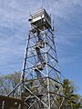
Mount Toby is special because it has many different kinds of plants and animals. It also has beautiful forests, amazing waterfalls, and unique ponds. These ponds, like Cranberry Pond, were formed by glaciers long ago. The top of Mount Toby is covered with trees. However, there is a fire tower that you can climb. From the tower, you can see all around! You can spot other mountains, the Connecticut River, and even a peace pagoda. There are also cliffs on the lower parts of the mountain. These cliffs offer great views of the Connecticut River Valley and Sunderland town.
Contents
What is the History of Mount Toby?
Mount Toby gets its name from Captain Elnathan Toby. He was a settler from colonial Springfield. People say he was the first European person to reach the top of the mountain.
Long ago, in the 1700s, a hotel was built on the summit of Mount Toby. This was a common thing for mountains in the Connecticut River Valley. But the hotel burned down just one year after it was built. It was never rebuilt. Later, the land became part of the Massachusetts Agricultural College. This college is now known as the University of Massachusetts Amherst. Today, Mount Toby is part of the Mount Toby State Demonstration Forest. The University of Massachusetts Amherst still owns and manages it.
What is Mount Toby's Geology and Ecosystem Like?
.jpg)
Mount Toby is known for having a very high biodiversity. This means it has many different types of living things. It is one of the most biodiverse areas in New England. Many kinds of ferns and orchids grow here. For example, 42 out of 45 native fern species can be found on the mountain. Rare orchids, like the Showy Lady Slipper and the Ram's Head Lady Slipper, also grow here.
Unlike other areas nearby, Mount Toby's forests were never completely cut down. This happened during the time when New England was mostly farms in the 1700s and 1800s. Mount Toby has always stayed wooded, even though some trees have been harvested over time.
How Was Mount Toby Formed?
Mount Toby is made of a type of rock called Mount Toby Conglomerate. This rock is like a mix of different pebbles and stones cemented together. The mountain's formation is linked to the Metacomet Ridge. This ridge stretches across New England from Long Island Sound to the Vermont border.
Mount Toby is part of a "layer cake" of different rocks.
- The bottom layer is arkose sandstone. You can see this rock across the Connecticut River on Sugarloaf Mountain.
- The middle layer is basalt. This rock forms the Pocumtuck Ridge to the north.
- The top layer, which is the youngest, is the Mount Toby Conglomerate.
About 200 million years ago, the continent of North America started to pull away from Africa and Eurasia. This caused the land to crack and move. Over time, there were periods of erosion (wearing away of rock) and deposition (laying down of new material). There were also many lava flows. This created the layered rocks we see today. Earthquakes tilted these layers. Then, glaciers and erosion wore away parts of the land. This exposed the tilted layers of sandstone, basalt, and the tough conglomerate. Even though Mount Toby is not made of the same "trap rock" as the Metacomet Ridge, it formed in a similar way.
Where Does the Water Go?
Water from the west and south sides of Mount Toby flows into small streams. These streams then join the Connecticut River, which eventually reaches Long Island Sound. Water from the east side flows into Long Plain Brook, then into the Connecticut River. The north side's water drains into Cranberry Pond Brook, also leading to the Connecticut River.
What Waterfalls Can You Find on Mount Toby?
Mount Toby is home to several beautiful waterfalls.


- Roaring Brook Falls is on the east side of the mountain. It has a series of falls, pools, and cascades that drop 100 feet. These falls are most impressive in the spring or after heavy rain. In winter, they often freeze, and in dry times, they can be just a trickle. You can only reach Roaring Brook Falls by hiking trails.
- Gunn Brook Falls is on the lower west side of the mountain, close to the Connecticut River. It's smaller but usually has more water flowing. You can reach it easily from a public road.
- Slatestone Brook Falls is on private land but can be seen from the road.
- Slip Dog Falls is in the middle of the mountain, away from roads.
- Green Swamp Brook Falls is on the south side of the mountain.
What Activities Can You Do on Mount Toby?

Mount Toby is a popular place for hiking. It has many trails. The 47 mi (76 km) Robert Frost Trail even crosses the mountain from south to north. However, many of the trails are not clearly marked. Since the area is also used for education and research, trees might have other markings that could confuse hikers. It's a good idea for hikers to use recent topographic maps and orienteering skills to find their way.
Besides hiking, people also enjoy horseback riding, fishing, ice skating, snowshoeing, cross-country skiing, and mountain biking on Mount Toby. Most of the public trailheads (starting points for trails) on the east side are not easy to reach by public transportation. The closest bus stop is in Sunderland, and these buses can carry bicycles.
How is Mount Toby Protected?
A large part of Mount Toby is protected land. Some areas are part of the Mount Toby State Demonstration Forest. Other parts are owned or managed by groups like the Nature Conservancy, the Trustees of Reservations, and the United States Fish and Wildlife Service. Local conservation groups also help protect the mountain. However, a big part of the mountain is still privately owned. The Cowls Lumber Company is one of the largest private landowners.
Images for kids
-
Mount Toby as seen from South Sugarloaf
-
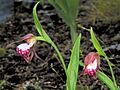
Ram's Head Lady Slipper
-
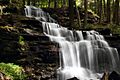
Gunn Brook Falls Sunderland, MA
-
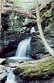
Middle basin, Roaring Falls
-
The Mount Toby Fire Tower
