Whately, Massachusetts facts for kids
Quick facts for kids
Whately, Massachusetts
|
|||
|---|---|---|---|

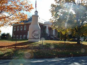
The "Whately Milk Bottle" in front of the old Whately Central School (built 1910)
|
|||
|
|||

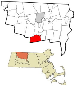
Location in Franklin County in Massachusetts
|
|||
| Country | United States | ||
| State | Massachusetts | ||
| County | Franklin | ||
| Settled | 1672 | ||
| Incorporated | 1771 | ||
| Government | |||
| • Type | Open town meeting | ||
| Area | |||
| • Total | 20.7 sq mi (53.5 km2) | ||
| • Land | 20.2 sq mi (52.3 km2) | ||
| • Water | 0.5 sq mi (1.2 km2) | ||
| Elevation | 381 ft (116 m) | ||
| Population
(2020)
|
|||
| • Total | 1,607 | ||
| • Density | 77.63/sq mi (30.04/km2) | ||
| Time zone | UTC−5 (Eastern) | ||
| • Summer (DST) | UTC−4 (Eastern) | ||
| ZIP Code |
01093
|
||
| Area code(s) | 413 | ||
| FIPS code | 25-79110 | ||
| GNIS feature ID | 1729674 | ||
Whately (pronounced WAIT-lee) is a small town in Franklin County, Massachusetts, United States. It is part of the Springfield area. In 2020, about 1,607 people lived there.
Contents
History of Whately
Whately started as a northern part of the town of Hatfield in 1672. The people living there asked to become their own town. They were quite far from the main part of Hatfield.
In 1771, Whately officially became its own town. It was named by Governor Thomas Hutchinson. He named it after Thomas Whately, who was a Member of Parliament in England. A letter from Thomas Whately to Governor Hutchinson caused some trouble later on.
In 1971, Julian Whately, a family member of Thomas Whately, visited the town. This visit happened during the town's 200th birthday celebration.
Whately was home to the first gin distillery in Massachusetts. It also had other small factories. These included mills for making wool and furniture. Farmers in Whately used the town's water for growing crops. They also raised dairy cows. Whately even had one of the few fields outside of Indonesia where Sumatran tobacco was grown.
Geography and Location
Whately covers about 20.7 square miles (53.5 square kilometers). Most of this area is land, with a small part being water. The town is located in the southern part of Franklin County. It shares borders with several other towns. These include Conway, Deerfield, Sunderland, Hatfield, and Williamsburg.
Whately is about 11 miles (18 km) south of Greenfield. It is also about 26 miles (42 km) north of Springfield. Boston is about 95 miles (153 km) to the east.
Natural Features
Whately is on the western side of the Connecticut River. This area is known as the Pioneer Valley. The western part of Whately has many hills. The highest point is Mount Esther, which is 980 feet (299 meters) tall.
The Mill River flows through the town. There are also some swampy areas near the river. More marshy land is found closer to the Connecticut River. Much of the land near these rivers is used for farming.
Roads and Travel
Interstate 91 runs through Whately from north to south. You can get on or off the highway at Exit 23. U.S. Route 5 and Massachusetts Route 10 also go through Whately. These routes run close to the interstate.
Whately used to share a small airport called Pilgrim Airport with Hatfield. However, this airport is now closed. The land is used for farming. The closest small airport is Northampton Airport. For bigger flights, people use Bradley International Airport in Windsor Locks, Connecticut.
Population and People
| Historical population | ||
|---|---|---|
| Year | Pop. | ±% |
| 1850 | 1,101 | — |
| 1860 | 1,057 | −4.0% |
| 1870 | 1,068 | +1.0% |
| 1880 | 1,074 | +0.6% |
| 1890 | 779 | −27.5% |
| 1900 | 769 | −1.3% |
| 1910 | 846 | +10.0% |
| 1920 | 1,234 | +45.9% |
| 1930 | 1,136 | −7.9% |
| 1940 | 979 | −13.8% |
| 1950 | 939 | −4.1% |
| 1960 | 1,037 | +10.4% |
| 1970 | 1,145 | +10.4% |
| 1980 | 1,341 | +17.1% |
| 1990 | 1,375 | +2.5% |
| 2000 | 1,573 | +14.4% |
| 2010 | 1,496 | −4.9% |
| 2020 | 1,607 | +7.4% |
| 2022 | 1,625 | +1.1% |
Source: United States Census records and Population Estimates Program data. |
||
In 2000, there were 1,573 people living in Whately. This made it the fifteenth largest town in Franklin County by population. There were 629 households in the town. About 29.6% of these households had children under 18 living there.
The population of Whately is spread out by age. About 21.8% of the people were under 18 years old. About 12.3% were 65 years or older. The average age in Whately was 41 years.
Education in Whately
Whately is part of the Frontier Regional and Union 38 School Districts. These districts also include the towns of Conway, Deerfield, and Sunderland.
Each town has its own elementary school. Students in Whately go to Whately Elementary School from Pre-Kindergarten through sixth grade. After sixth grade, all students from these four towns attend Frontier Regional High School in Deerfield.
There are also some private schools in nearby Deerfield. More schools are located in the Greenfield and Northampton areas.
For higher education, the closest community college is Greenfield Community College in Greenfield. The nearest state university is the University of Massachusetts Amherst. There are also several private colleges in the Northampton area.
See also
 In Spanish: Whately (Massachusetts) para niños
 | Delilah Pierce |
 | Gordon Parks |
 | Augusta Savage |
 | Charles Ethan Porter |


