
Southwick, Massachusetts facts for kids
Quick facts for kids
Southwick, Massachusetts
|
||
|---|---|---|

Southwick Congregational Church
|
||
|
||

Location in Hampden County in Massachusetts
|
||
| Country | United States | |
| State | Massachusetts | |
| County | Hampden | |
| Settled | 1690 | |
| Incorporated | November 7, 1770 | |
| Government | ||
| • Type | Open town meeting, Board of selectmen |
|
| Area | ||
| • Total | 31.7 sq mi (82.0 km2) | |
| • Land | 30.8 sq mi (79.8 km2) | |
| • Water | 0.8 sq mi (2.2 km2) | |
| Elevation | 244 ft (74 m) | |
| Population
(2020)
|
||
| • Total | 9,232 | |
| • Density | 291.59/sq mi (112.59/km2) | |
| Time zone | UTC−5 (Eastern) | |
| • Summer (DST) | UTC−4 (Eastern) | |
| ZIP Code |
01077
|
|
| Area code(s) | 413 | |
| FIPS code | 25-65825 | |
| GNIS feature ID | 0618191 | |

Southwick is a town in Hampden County, Massachusetts, United States. It's a part of the Springfield area. In 2020, about 9,232 people lived there.
Contents
Discovering Southwick's Past
Southwick was first home to Native American tribes like the Matitacooke, Mayawaug, or Woronoake.
Early Settlement and Growth
In the mid-1600s, English explorers came to the Connecticut River Valley. They found Southwick and settled there. It became a farming community. The name "Southwick" means the "Southern village" of Westfield.
People first called it "Poverty Plains." This was because they thought the land wasn't good for farming. The first home was built by Samuel Fowler and his wife Naomi Noble. It was on what is now College Highway.
Back in colonial times, everyone had to go to church. The 800 Christian residents of Southwick had to travel to Westfield. They wanted their own church closer to home. So, on November 7, 1770, Southwick became a separate district of Westfield. At that time, a small part of Southwick joined Suffield, Connecticut.
Becoming an Independent Town
Southwick became a fully independent town in 1770. But there was a disagreement about the border with Connecticut. This argument continued until 1804. A compromise was reached, and the current border was set. Because of this, Southwick is the southernmost town in western Massachusetts.
.jpg)
Southwick in the 1800s
In the early 1800s, two canals were built: the Farmington Canal and the Hampshire and Hampden Canal. These canals connected New Haven, Connecticut to Northampton through Southwick. Many Irish immigrants came to work on this project. People even called Southwick the "Port of the World." You can still find parts of the canal near the Great Brook and Congamond Lakes.
However, the canals had problems. They would freeze in winter and dry up in summer. Animals like beavers also caused issues. So, people decided to build a railroad instead.
The New Haven and Northampton Company's railroad was finished in the late 1840s. It was built next to the old canal. The railroad brought new industries and tourism to Southwick.
Ice and Tourism Boom
The railroad helped the ice industry grow. Ice from the Congamond Lakes was cut into blocks. It was stored in large ice houses. Then, it was sent by train to cities like New York City and Boston. This was how food was kept cold before electric refrigerators.
The railroad also brought tourists to the Congamond Lakes. The Native Americans had called these lakes Wenekeiamaug. An amusement park was built, along with fancy hotels and dance halls. During the Industrial Era, people from big cities came to Southwick for summer vacations. Cities like New York City, Albany, Boston, Worcester, Hartford, and Springfield were all connected by the railroad. There was a special train stop near the lakes. Visitors would get off to swim or ride in boats.
During World War I and World War II, trains carrying soldiers passed through Southwick. Local girls would collect letters that soldiers threw from the trains. They would then mail them for the soldiers. The last train ran on these tracks around 1976. Today, the old railway is a walking and biking path. It's called the Farmington Canal Rail Trail.
Most of Southwick's old hotels and train stations are gone now. Only Babb's Roller Skating Rink remains from the amusement park. It is on the Suffield side of Congamond Lakes.
Local Industries
Tobacco Farming
Southwick's farmland is great for growing tobacco. This plant is grown widely as a cash crop, meaning it's grown to be sold.
Ice Harvesting
Before refrigerators, people collected ice from the Congamond Lakes. They stored it in big ice houses. This ice was then sent by train to cities for food storage.
Geography and Nature


Southwick is the southernmost town in western Massachusetts. This is because of a "jog" in the border with Connecticut.
Southwick is surrounded by other towns:
- To the north: Westfield
- To the east: Agawam, Massachusetts and Suffield, Connecticut
- To the south: Suffield and Granby, Connecticut
- To the west: Granby and Granville, Massachusetts
U.S. Route 202 (College Highway) goes through the town. It leads north to Westfield and south to Granby, Connecticut. Massachusetts Route 57 crosses Southwick from east to west. It goes east to Springfield and west into the Berkshires.
Southwick has a total area of about 82 square kilometers (31.7 square miles). Most of this is land, with a small amount of water.
The Metacomet-Monadnock Trail is a long hiking trail. It goes through wetlands near Harts Pond. Then, it climbs over Provin Mountain. This mountain is a rocky ridge that forms the eastern border of Southwick. Provin Mountain is part of the Metacomet Ridge. This is a chain of mountains that stretches from Long Island Sound to near the Vermont border.
Population and People
In 2000, there were 8,835 people living in Southwick. The average household had about 2.66 people. The average family had about 3.13 people.
The population included people of different ages:
- 26.5% were under 18 years old.
- 6.3% were from 18 to 24 years old.
- 32.2% were from 25 to 44 years old.
- 23.2% were from 45 to 64 years old.
- 11.7% were 65 years or older.
The average age in Southwick was 38 years. For every 100 females, there were about 100.4 males.
Education for Southwick Students
Southwick is part of the Southwick-Tolland-Granville Regional School District. This district also includes Granville and Tolland.
Here's where students go to school:
- Woodland School: For students in K through 2nd grade.
- Powder Mill School: For students in 3rd through 6th grade.
- Southwick Regional School: For high school students in 7th through 12th grade.
In 2012, people in Southwick voted to approve a big school project. It cost $62 million to renovate and build new parts of the school. This project was finished in 2015.
Images for kids
-
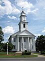
Southwick Congregational Church
-
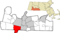
Location in Hampden County in Massachusetts
-
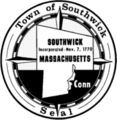
Seal of Southwick, Massachusetts
See also
 In Spanish: Southwick (Massachusetts) para niños
