Tolland, Massachusetts facts for kids
Quick facts for kids
Tolland, Massachusetts
|
||
|---|---|---|

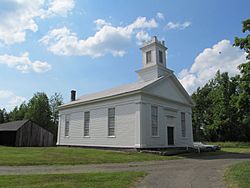
Congregational Church
|
||
|
||

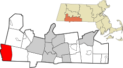
Location in Hampden County in Massachusetts
|
||
| Country | United States | |
| State | Massachusetts | |
| County | Hampden | |
| Settled | 1750 | |
| Incorporated | 1810 | |
| Government | ||
| • Type | Open town meeting | |
| Area | ||
| • Total | 32.8 sq mi (84.9 km2) | |
| • Land | 31.5 sq mi (81.7 km2) | |
| • Water | 1.2 sq mi (3.2 km2) | |
| Elevation | 1,519 ft (463 m) | |
| Population
(2020)
|
||
| • Total | 471 | |
| • Density | 14.368/sq mi (5.548/km2) | |
| Time zone | UTC−5 (Eastern) | |
| • Summer (DST) | UTC−4 (Eastern) | |
| ZIP Code |
01034
|
|
| Area code(s) | 413 | |
| FIPS code | 25-70045 | |
| GNIS feature ID | 0618192 | |
Tolland is a small town located in Hampden County, Massachusetts, in the United States. It is part of the larger Springfield area. In 2020, about 471 people lived there. This makes Tolland the smallest town in Hampden County based on its population.
Contents
History of Tolland
Tolland was first settled by people in 1750. At that time, it was part of a nearby town called Granville. Later, in 1810, Tolland officially became its own separate town.
Geography of Tolland
Tolland is in the southwestern part of Hampden County. It shares borders with several other towns and states.
- To the north, it borders Otis and Blandford.
- To the east, it borders Granville.
- To the south, it borders Hartland and Colebrook, Connecticut in Connecticut.
- To the west, it borders Sandisfield.
Massachusetts Route 57 is a main road that goes through the middle of Tolland. This road connects the town to Agawam to the east and New Marlborough to the west.
Waterways and Land Area
The West Branch of the Farmington River forms most of Tolland's western edge. The southern part of Otis Reservoir is in the northern area of the town. Rivers and streams in Tolland flow into the Connecticut River watershed. This means all the water from these rivers eventually makes its way to the Connecticut River.
The town covers a total area of about 84.9 square kilometers (32.8 square miles). Most of this area, about 81.7 square kilometers (31.5 square miles), is land. The rest, about 3.2 square kilometers (1.2 square miles), is water.
Natural Areas
A significant part of Tolland's land is protected. This includes areas within Tolland State Forest and Granville State Forest. These forests help preserve the natural beauty and wildlife of the town.
Population and People
| Historical population | ||
|---|---|---|
| Year | Pop. | ±% |
| 1850 | 594 | — |
| 1860 | 596 | +0.3% |
| 1870 | 509 | −14.6% |
| 1880 | 452 | −11.2% |
| 1890 | 393 | −13.1% |
| 1900 | 275 | −30.0% |
| 1910 | 180 | −34.5% |
| 1920 | 192 | +6.7% |
| 1930 | 134 | −30.2% |
| 1940 | 129 | −3.7% |
| 1950 | 107 | −17.1% |
| 1960 | 101 | −5.6% |
| 1970 | 172 | +70.3% |
| 1980 | 235 | +36.6% |
| 1990 | 289 | +23.0% |
| 2000 | 426 | +47.4% |
| 2010 | 485 | +13.8% |
| 2020 | 471 | −2.9% |
| 2022* | 467 | −0.8% |
| * = population estimate. Source: United States Census records and Population Estimates Program data. |
||
In 2000, there were 426 people living in Tolland. They lived in 169 households, with 114 of these being families. The town had about 13.5 people per square mile. Most of the people living in Tolland were White.
The population included people of all ages. About 23.9% of the residents were under 18 years old. The median age in the town was 41 years old. This means half the people were younger than 41, and half were older.
Education in Tolland
Tolland is part of the Southwick Regional School District. This district also includes the towns of Granville and Southwick.
- Younger students attend Woodland School for grades K-2.
- Students in grades 3-6 go to Powder Mill School.
- For middle and high school, students attend Southwick Regional School for grades 7-12.
Tolland Public Library
The Tolland Public Library first opened in 1892. It serves as an important resource for the community. In 2008, the town spent about $10,271 on its public library. This worked out to about $22 per person each year.
Notable Person from Tolland
- John Easton Mills (1796–1847) was born in Tolland. He later became the fifth Mayor of Montréal, Canada, serving from 1846 to 1847.
See also
 In Spanish: Tolland (Massachusetts) para niños
 | Jewel Prestage |
 | Ella Baker |
 | Fannie Lou Hamer |


