
Farmington River facts for kids
Quick facts for kids Farmington River |
|
|---|---|

Looking downstream on the Farmington River in Simsbury, Connecticut
|
|
| Country | United States |
| State | Massachusetts & Connecticut |
| Physical characteristics | |
| Main source | outlet of Hayden Pond (West Branch of the Farmington River) Otis, Berkshire County, Massachusetts |
| 2nd source | Barkhamsted Reservoir (East Branch of the Farmington River) Hartland, Hartford County, Connecticut |
| River mouth | confluence with Connecticut River Windsor, Hartford County, Connecticut 41°50′37.3596″N 72°37′52.6368″W / 41.843711000°N 72.631288000°W |
| Length | 80.4 mi (129.4 km), from source of West Branch |
| Basin features | |
| Basin size | 602 sq mi (1,560 km2) |
| Official name: Farmington River (West Branch) | |
| Type: | Recreational |
| Designated: | August 26, 1994 |
The Farmington River is a river that flows through northwest Connecticut and southwest Massachusetts. Its main part is about 47 miles (75 kilometers) long. However, if you measure from the very start of its West Branch, the river is about 80 miles (129 kilometers) long. This makes it the longest river that flows into the Connecticut River.
The Farmington River's watershed covers a large area of about 609 square miles (1,577 square kilometers). In the past, the river was important for small factories in the towns along its path. Today, it is mostly used for fun activities like boating and as a source of drinking water.
Contents
River's Journey: Where the Farmington River Flows
The Farmington River has two main parts: the East Branch and the West Branch. Both of these branches start in southwestern Massachusetts. However, only the West Branch officially begins north of the Connecticut border.
West Branch: Starting in Massachusetts
The West Branch of the river begins at the end of Hayden Pond in Otis, Massachusetts.
East Branch: From Brooks to Reservoirs
The East Branch starts in Hartland, Connecticut. It forms where three smaller streams, Pond, Hubbard, and Valley Brooks, meet. This branch has been blocked by dams to create two large lakes: the Barkhamsted Reservoir and Lake McDonough. The East Branch only starts to look like a river after it leaves Lake McDonough in New Hartford, Connecticut.
Where the Branches Meet
The East Branch and West Branch of the Farmington River join together in New Hartford, Connecticut. This meeting point is about one mile south of Lake McDonough.
River's Path to the Connecticut River
At first, the river flows mostly south. But when it reaches Farmington, Connecticut, it turns and flows mostly north and east. Finally, the Farmington River flows into the Connecticut River in Windsor.
History of the Farmington River
The Farmington River was once home to a Native American group called the Massaco. They lived and fished along the river in what is now the Simsbury and Canton area of Connecticut. The river later got its name "Farmington."

The land where the Massaco lived was later bought by the Dutch. More about this and the early settlements can be found in the history of Simsbury.
The Spoonville Dam
The Spoonville Dam was built on the Farmington River in 1899. It was located below the Tariffville Gorge in East Granby. This dam was damaged during a big flood in 1955. It stayed partly broken for many years before it was completely removed in 2012. The dam and a nearby bridge were named after a silver plating factory. This factory, built in 1840, was the first of its kind in the United States.
Old Bridges Still Standing
Many bridges built in the 1800s and early 1900s still cross the Farmington River today. Some of these include:
- Farmington River Railroad Bridge: A stone arch bridge in Windsor, Connecticut, built in 1867.
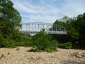
- Drake Hill Road Bridge: A Parker through-truss bridge in Simsbury, Connecticut, built in 1892.
- Town Bridge: A Parker through-truss bridge in Canton, Connecticut, built in 1895.
- Richards Corner Bridge: A Pratt through-truss bridge in New Hartford, Connecticut, built in 1930. It crosses the East Branch Farmington River.
- Pleasant Valley Bridge: A Parker through-truss bridge in Barkhamsted, Connecticut, built in 1939.
- Unionville Bridge: A Warren through-truss bridge in Unionville, Connecticut, built in 1939.
Fun on the Farmington River
The Farmington River has parts with fast-moving water, which are great for tubing and kayaking.
Whitewater Adventures
- Upper Farmington Section: This part of the West Branch in New Boston, Massachusetts, is about 7 miles (11 km) long. It has Class 2 rapids, which are good for beginners. Further down, it becomes Class 3-4, with some exciting drops and many rocks. The river keeps moving fast, with bigger drops at places like Battering Ram and Corkscrew. It then calms down to Class 2 before a final drop at Bear's Den.
- Tariffville Gorge: This section in Tariffville, Connecticut, is about one mile (1.6 km) long. It has Class 3 rapids and can be used all year. It includes the famous T-ville Hole, where kayakers can practice tricks. Below this is a broken dam, which creates a big wave. This area is popular for swimming in summer, but it can be dangerous due to strong currents and hidden rocks. It's important to be safe and have the right gear, like helmets and lifejackets, if you go into the gorge.


Tubing and Training Waters
- Satan's Kingdom: Located in New Hartford, Connecticut, this area is very popular for tubing.
- Crystal Rapids: This section in Collinsville and Unionville, Connecticut, is about four miles (6 km) long. It has Class 1-3 rapids, which are good for training. There's also a path next to the river for biking and walking. You can enter the park for free. There are also services that will pick up and drop off tubers at certain spots.
Dams and Power on the River
The Farmington River has several dams that are used for different purposes.
Hydroelectric Dams
- West Branch Dams: The west branch of the river has two hydroelectric dams. These dams use the power of moving water to create electricity. They are located in West Hartland and Colebrook and are run by the Metropolitan District Commission of Connecticut.

- Saville Dam: This is the largest dam on the east branch. It creates the Barkhamsted Reservoir, which holds a lot of water.
- Rainbow Dam: This dam is about 68 feet (21 meters) tall and is located in Windsor, just a few miles before the river flows into the Connecticut River. It also has a hydroelectric generator and a fish ladder, which helps fish swim past the dam.
Many other dams were built on the river after Europeans settled here. They were often used to power mills and other factories. Some of these old dams, like those in Collinsville, are still mostly in place. There have been efforts to restart some small power dams along the river.
Water released from the Otis Reservoir dam flows into the Farmington River in Otis, Massachusetts. A lot of water is let out in the fall to lower the reservoir's water level for winter.
Protecting the Farmington River
A large part of the Farmington River is special because it's part of the United States National Wild & Scenic Rivers System. This means it's protected for its natural beauty and importance.
Wild & Scenic Designation
- The first part of the river to get this special protection was in 1994. It included 14 miles (22.5 km) of water, mostly along the West Branch and a section of the main river.
- In 2019, this protected area was made even longer. An additional 61.7 miles (99.3 km) of the main river and its Salmon Brook tributary were also named Wild & Scenic.
A group called the Farmington River Coordinating Committee helps manage these protected parts of the river. It includes people from towns along the river, environmental groups, and government agencies.
River Life: Freshwater Mussels
The Farmington River and its smaller streams are home to 11 different kinds of freshwater mussels. The Farmington River has more types of mussels than any other river that flows into the Connecticut River.
Images for kids
-
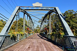
Drake Hill Road Bridge, built in 1892 to span the Farmington River in Simsbury, Connecticut
-
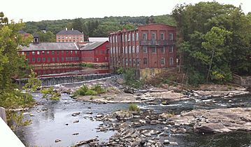
Historic mills along the Farmington River in the Collinsville section of Canton, Connecticut.
-
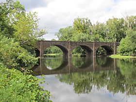
A stone arch bridge built in 1867 which still spans the Farmington River in Windsor, Connecticut.
-
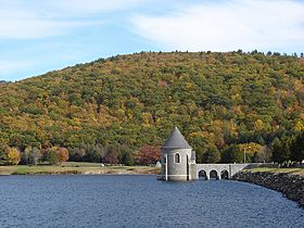
The Saville Dam impounds the East Branch Farmington River to form Barkhamsted Reservoir.
-
Town Bridge, built in 1895 over the Farmington River in Canton, Connecticut.


