
Windsor, Connecticut facts for kids
Quick facts for kids
Windsor
|
||
|---|---|---|
| Town of Windsor | ||

Windsor Town Hall, located on Broad Street
|
||
|
||
| Motto(s):
First in Connecticut, First for its Citizens
|
||
 Hartford County and Connecticut Hartford County and Connecticut Capitol Planning Region and Connecticut Capitol Planning Region and Connecticut |
||
| Country | ||
| U.S. state | ||
| County | Hartford | |
| Region | Capitol Region | |
| Settled | September 26, 1633 | |
| Incorporated | February 21, 1637 | |
| Named for | Windsor, Berkshire | |
| Government | ||
| • Type | Council-manager | |
| Area | ||
| • Total | 31.0 sq mi (80.2 km2) | |
| • Land | 29.5 sq mi (76.4 km2) | |
| • Water | 1.5 sq mi (3.8 km2) | |
| Elevation | 55 ft (17.37 m) | |
| Population
(2020)
|
||
| • Total | 29,492 | |
| • Density | 952.4/sq mi (367.73/km2) | |
| Demonym(s) | Windsor-head | |
| Time zone | UTC−5 (Eastern) | |
| • Summer (DST) | UTC−4 (Eastern) | |
| ZIP Code |
06095
|
|
| Area code(s) | 860/959 | |
| FIPS code | 09-87000 | |
| GNIS feature ID | 0212354 | |
| Interstates | ||
| List of auxiliary Interstate Highways | ||
| State Routes |  |
|
| Commuter Rail | ||
| Elevation noted at Town Hall. | ||

Windsor is a town in Hartford County, Connecticut, USA. It was the very first English settlement in the state of Connecticut! Windsor is located right on the northern edge of Hartford, which is the capital city of Connecticut. It's also part of the Capitol Planning Region. In 2020, about 29,492 people lived in Windsor.
A northern part of Windsor is called Poquonock. It even has its own zip code for mail! Other areas in Windsor include Rainbow and Hayden Station in the north, and Wilson and Deerfield in the south.
Windsor has a special area called Day Hill Road, known as its Corporate Area. This is where many businesses are located. Other business spots include New England Tradeport and Kennedy Industry Park, which are close to Bradley International Airport.
| Top - 0-9 A B C D E F G H I J K L M N O P Q R S T U V W X Y Z |
Discovering Windsor's Past
Early Settlements and Native Americans
Long ago, Native American groups lived along the rivers and coasts of this area. They used the rivers for fishing, water, and travel. Before Europeans arrived, the Pequot and Mohegan tribes were once one group. They spoke an Algonquian language. Later, they separated and became rivals in Connecticut.
In the early 1600s, the Pequot and Mohegan nations were at war. The Podunk tribe had to pay tribute to the stronger Pequot tribe, who claimed their land. The Podunk invited a small group of settlers from Plymouth, Massachusetts, to help make peace between the tribes. In return, they gave the settlers land where the Farmington River meets the Connecticut River.
On September 26, 1633, a group led by William Holmes arrived and started a trading post. This spot is now part of the sports fields for the Loomis Chaffee School. Native Americans called this area Matianuck. It was a great location for the English to trade with the Native Americans before they reached the Dutch settlement further downriver.
English Settlers Arrive
In 1635, another group of about 30 people, led by the Stiles brothers, settled in the Windsor area. Governor John Winthrop of the Massachusetts Bay Company noted that this was the second group to settle Connecticut.
The first large group of over 60 people arrived from Dorchester, Massachusetts. They were led by Roger Ludlow, who helped create the Fundamental Orders of Connecticut. These settlers had come to America five years earlier on the ship Mary and John. Reverend Warham quickly renamed the Connecticut settlement "Dorchester." More settlers arrived from Dorchester, and they soon outnumbered the original Plymouth group. The Plymouth group returned home in 1638.
On February 21, 1637, the colony's General Court changed the settlement's name from Dorchester to Windsor. It was named after the town of Windsor, Berkshire, in England. On the same day, Windsor became an official town, along with Hartford and Wethersfield.
Over time, parts of Windsor's original land were used to form many other towns. These include Bloomfield, East Granby, East Windsor, Granby, South Windsor, and Windsor Locks.
Early Roads and Trade
The first "highway" in the Connecticut Colony opened in 1638, connecting Windsor and Hartford. Two years later, this road was extended north to Springfield. This connected the four main settlements in the region.
In 1640, there was a grain shortage. William Pynchon, the founder of Springfield, tried to buy grain from the Native Americans for Windsor, Hartford, and Springfield. When the Native Americans wouldn't sell at a fair price, Windsor and Hartford sent John Mason to negotiate. The Native Americans eventually sold their grain. After this, Springfield decided to side with the Massachusetts Bay Colony instead of the Connecticut Colony. Windsor chose to stay with Connecticut.
Trolleys, which are like electric buses on tracks, connected Windsor Center with the Connecticut Company until 1925. Buses replaced trolleys in some areas in 1930. Trolley cars ran from Windsor to Hartford until 1940.
Many people living today are descendants of the original Windsor settlers. They are often members of the Descendants of the Founders of Ancient Windsor (DFAW).
The Springfield Line of the NY, New Haven & Hartford Railroad had stops in Windsor Center, Wilson, and Hayden. An old brownstone arch bridge from 1856 carries the tracks over Pleasant Street and the Farmington River.
Exploring Windsor's Geography

Windsor's highest point is on Day Hill, about 230 feet (70 meters) above sea level. Its lowest point is on the Connecticut River, only about 5 feet (1.5 meters) above sea level.
The Connecticut River forms Windsor's eastern border. To the south, Windsor is next to Hartford, the state capital. To the north is Windsor Locks, where Bradley International Airport is located. The towns of East Windsor and South Windsor are across the Connecticut River to the east. Bloomfield is to the west, and East Granby is to the northwest.
The Farmington River flows into the Connecticut River in Windsor. A dam on the Farmington River in northwestern Windsor creates the 234-acre (0.95 km2) Rainbow Reservoir.
Historical Places to Visit

The famous play and movie Arsenic and Old Lace was inspired by real events in Windsor. A house on Prospect Street was where a woman named Amy Archer-Gilligan was involved in the deaths of many men between 1907 and 1917. Most were found to be victims of arsenic poisoning.
On historic Palisado Avenue, you can find the First Church in Windsor, Congregational, and its old graveyard. Across the street, on the Palisado Green, there's a statue of John Mason. He was a founder of Windsor and a leader in the Pequot War.
Further north is the home of Oliver Ellsworth, who was the third Chief Justice of the United States.
Windsor's town center is well-planned. It has a mix of chain stores and local shops. There's also a restored Amtrak train station from the 1850s. The Vintage Radio and Communications Museum of Connecticut is also in Windsor.
From 1957 to 2006, Windsor was home to a special training unit for the Naval Nuclear Propulsion Program. This was a prototype nuclear power plant. It's now the first nuclear reactor site to be completely cleared and released for other uses after being taken apart and cleaned.
Other Interesting Sites

,_Windsor,_CT_-_April_2016_(1).JPG)
Windsor has many places listed on the National Register of Historic Places. These are important historical sites. Some examples include:
- The Oliver Ellsworth Homestead at 778 Palisado Avenue.
- The Farmington River Railroad Bridge, which crosses the Farmington River.
- The Hartford & New Haven Railroad Depot at 41 Central Street, which is now the Windsor train station.
- The Hartford & New Haven Railroad-Freight Depot at 40 Central Street, which is now the Windsor Art Center.
- The Palisado Avenue Historic District, a historic area along Palisado Avenue.
Tobacco Farming in Windsor
Tobacco farming has a long history in Connecticut. When the first settlers arrived in the 1630s, Native Americans were already growing tobacco. By 1700, tobacco was being shipped from the Connecticut River to Europe. Connecticut tobacco became famous for being used as the outer wrapper of cigars starting in the 1820s.
Farmers in the area grew tobacco for the outer layers of cigars. About 34,000 acres (138 km2) of land in Connecticut has a special soil called Windsor Soil, named after the town.
The movie Parrish, starring Troy Donahue, was filmed on Windsor's tobacco farms in 1961.
You can learn more about tobacco farming at the Connecticut Valley Tobacco Museum. It's located at Northwest Park in Windsor and has old farming tools.
Community and Organizations
Windsor has many groups that help the community. These include:
- Community Health Resources (CHR)
- Easterseals Capital Region & Eastern Connecticut
- Kiwanis Club of Windsor
- Mary's Place, A Center for Grieving Children and Families
- Rotary Club of Windsor
- Saint Casmir's Lithuanian Society Inc.
- VFW-Veterans of Foreign Wars-Windsor Post 4740
- Vintage Radio and Communications Museum of Connecticut
- Windsor Art Center
- Windsor Food and Fuel Bank
- Windsor Historical Society
Windsor's Population and Economy
Population Details
The population of Windsor has grown a lot over the years. In 1820, there were about 3,008 people. By 2020, the population had grown to 29,492.
In 2010, there were 29,044 people living in Windsor. About 54.7% of the people were White, 34.3% were African American, and 4.5% were Asian. About 8.4% of the population was Hispanic or Latino.
The median age in Windsor in 2010 was 43.1 years old. This means half the people were younger than 43.1 and half were older.
Income and Jobs
The average income for a household in Windsor was about $78,211 between 2009 and 2011. For families, it was about $89,726.
Windsor is special because in the year 2000, the average income for Black households was slightly higher than for White households. Asian households had an even higher average income.
Top Employers in Windsor
Many people work in Windsor. Here are some of the top employers in 2023:
- Amazon.com (7,223 employees)
- Town of Windsor (1,181 employees)
- Voya Financial (723 employees)
- Walgreens (700 employees)
- SS & C Technologies Inc (500 employees)
- Eversource Energy (400 employees)
- Dollar Tree (375 employees)
- Waste Management (375 employees)
- TLD GSE (350 employees)
- Barnes Aerospace (300 employees)
Getting Around Windsor

Transportation Options
- Bradley International Airport is very close by, in Windsor Locks. This airport serves the Hartford area.
- Connecticut Transit offers several bus routes in Windsor. Some routes go to Hartford, and others connect different parts of Windsor. The "Bradley Flyer" bus goes between Hartford and Bradley International Airport.
- Interstates: I-91 has seven exits in Windsor, including a special lane for cars with multiple passengers (HOV lane). I-291 also starts in Windsor and connects I-91 with I-84.
- Train Station: There's a train station in Windsor Center. You can catch Amtrak trains like the Hartford Line and Northeast Regional here. CTrail Hartford Line trains also stop at this station.

Emergency Services
- Police: The Windsor Police Department is located at 100 Addison Road.
- Fire Department: The Windsor Volunteer Fire Department has five stations around town.
- Emergency Medical Services: The Windsor Volunteer Ambulance service is also at the Windsor Safety Complex.
Learning in Windsor
Public Schools
Windsor Public Schools serve students from pre-school through high school:
- Roger Wolcott Early Childhood Center (for pre-school and kindergarten, but now children attend their local district schools like Poquonock or Ellsworth).
- Four elementary schools (Grades K-5): Oliver Ellsworth Primary School, Clover Street Intermediate School, John F. Kennedy Intermediate School, and Poquonock Primary School.
- One middle school (Grades 6-8): Sage Park Middle School.
- One high school (Grades 9-12): Windsor High School.
Magnet Schools
The Capital Region Education Council (CREC) manages magnet schools in Windsor:
- The Academy of Aerospace and Engineering Middle School (Grades 6-8).
- The Academy of Aerospace and Engineering High School (Grades 9-12).
Libraries
Windsor has one public library with two locations:
- The Main Branch - Windsor Public Library.
- The Wilson Branch - Windsor Public Library.
Private Schools
Windsor is also home to several private schools:
- Loomis Chaffee is a well-known college preparatory school. It has a large campus where the Connecticut and Farmington rivers meet. The original Loomis Homestead, built in 1640, is one of the oldest buildings in the United States and is on the school's campus.
- Madina Academy is Connecticut's first full-time Islamic School, offering classes from preschool to 12th grade.
- Saint Gabriel's School is a private school for kindergarten through eighth grade.
- Trinity Christian School teaches pre-school.
- Praise, Power, Prayer Christian School also teaches pre-school.
- Branford Hall Career Institute and Baran Institute of Technology are on Day Hill Road.
Fun and Recreation
Parks and Nature
- Windsor Meadows State Park is in the southeast part of town, along the Connecticut River.
- Keney Park, in the south, is shared with Hartford. It has cricket fields and a golf course.
- Northwest Park is Windsor's largest park. It has a nature center, trails, and an animal barn with sheep, chickens, goats, and more.
- Welch Park is in the Poquonock neighborhood. It has a public pool, basketball court, baseball fields, tennis courts, and a playground.
- Stroh Park is off Route 159. It has a public pool, tennis courts, a playground, and a pond.
- Strawberry Hills Park is on River Street. It's a popular spot for canoeing and kayaking on the Farmington River.
- Mill Brook Open Space is a 95-acre (0.38 km2) property bought in 2014 to protect it as open space. It's great for walking, seeing wildlife, and protecting water quality. It's close enough for over 1,200 residents to walk to it in 10 minutes.
Events and Entertainment
- The Northwest Park Country Fair is held every fall.
- The Shad Derby Festival happens every spring in the town center.
- The Carol sing and torchlight parade celebrate the holiday season in December.
- You can play golf at Keney Park Golf Club.
- The movie Parrish was filmed on Windsor's tobacco farms in 1961.
- The movie Academy Boyz was filmed at Loomis Chaffee in 1997.
- A scene from the movie War of the Worlds was filmed along the Farmington River.
Places of Worship
Windsor has many different churches and religious centers:
- Sanctuary of Faith and Glory Church
- Hopewell Baptist Church
- Pilgrim Way Baptist Church
- Grace Baptist Church
- Greater St. Paul's Baptist Church of Deliverance
- Saint Gabriel's Church, Roman Catholic
- Saint Gertrude's Church, Roman Catholic
- Saint Joseph's Church, Roman Catholic
- The First Church in Windsor, United Church of Christ
- Poquonock Community Church, Congregational
- Wilson Congregational Church, United Church of Christ
- Holy Zion Church of the Jubilee
- Mount Carmel Christian Ministries
- Faith Community Church
- Grace Episcopal Church
- Archer Memorial AME Zion Church
- Trinity United Methodist Church
- Christ the King Lutheran Church
- Congregation Beth Ahm, Jewish
- Oasis Christian Church of Connecticut
- Tohrah Judea
- Connecticut Valley Church of Christ
- Praise Power & Prayer Christian Temple
- Islamic Center of Connecticut
- International Gospel Fellowship
Famous People from Windsor

Many notable people have connections to Windsor:
- Al Anderson: Guitarist and songwriter, known for being in the band NRBQ.
- Christopher Isaiah Baker: A professional American football player.
- Moe Drabowsky: A Major League Baseball pitcher.
- Oliver Ellsworth: The third Chief Justice of the United States and one of America's founding fathers, born in Windsor.
- John Fitch: Inventor of the steamboat.
- Mike Joy: A TV sports announcer, known for NASCAR coverage.
- Evelyn Beatrice Longman: The first woman sculptor to become a full member of the National Academy of Design.
- Joseph Hayne Rainey: The first African American elected to Congress, who lived in Windsor during summers.
- Iceman John Scully: A professional boxer and boxing broadcaster.
- Oliver Wolcott: Another American founding father, born in Windsor.
- Roger Wolcott: A colonial governor of Connecticut and father of Oliver Wolcott.
Main Areas of Windsor
Windsor is made up of several communities:
- Deerfield
- Hayden Station
- Poquonock
- Rainbow
- Wilson
- Windsor Center
Images for kids
-
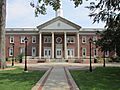
Windsor Town Hall
-
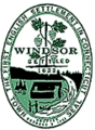
Seal of Windsor, Connecticut
-
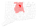
Windsor's location within Hartford County and Connecticut
-
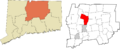
Windsor's location within the Capitol Planning Region and the state of Connecticut
-
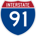
Interstate 91
-
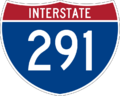
Interstate 291
-
Connecticut Route 20
-
Connecticut Route 75
-
Connecticut Route 159
-
Connecticut Route 178
-
Connecticut Route 187
-
Connecticut Route 218
-
Connecticut Route 305
-

Amtrak logo
-

Hartford Line logo


See also
 In Spanish: Windsor (Connecticut) para niños
