Tariffville, Connecticut facts for kids
Quick facts for kids
Tariffville, Connecticut
|
|
|---|---|

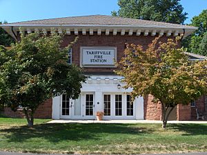
Tariffville Fire Station
|
|
| Country | United States |
| State | Connecticut |
| County | Hartford |
| Town | Simsbury |
| Area | |
| • Total | 0.65 sq mi (1.69 km2) |
| • Land | 0.60 sq mi (1.55 km2) |
| • Water | 0.05 sq mi (0.13 km2) |
| Elevation | 200 ft (60 m) |
| Population
(2010)
|
|
| • Total | 1,324 |
| • Density | 2,207/sq mi (852.2/km2) |
| Time zone | UTC-5 (Eastern) |
| • Summer (DST) | UTC-4 (Eastern) |
| ZIP code |
06081
|
| Area code(s) | 860 |
| FIPS code | 09-75100 |
| GNIS feature ID | 2377870 |
Tariffville is a small community located in the town of Simsbury, in Hartford County, Connecticut, United States. It is known as a census-designated place (CDP), which means it's a special area defined by the U.S. Census Bureau for collecting population data. In 2010, about 1,324 people lived there.
Tariffville is a popular spot for whitewater paddlers. They enjoy the exciting rapids of the Farmington River that flows through the area. A part of the old mill village in Tariffville is recognized as a Tariffville Historic District. This district is listed on the National Register of Historic Places because it helps preserve the look and feel of an early 19th-century mill town. It still has some of its original mill worker homes and street designs.
Contents
Geography of Tariffville
Tariffville is found in the very northeast part of Simsbury. It sits right inside a sharp bend of the Farmington River. The river forms the community's borders to the northeast and northwest. The northeastern border also marks the town line with East Granby.
Mountains and Borders
To the southeast, Tariffville's border follows the top of Talcott Mountain. This mountain ridge also acts as the town line with Bloomfield. The southern edge of Tariffville runs just south of West Point Terrace, stretching from Talcott Mountain back to the river.
Roads and Waterways
Connecticut Route 189, also called Hartford Avenue, goes through the eastern side of Tariffville. This road leads north about 3.5 miles (5.6 km) to Granby and south about 12 miles (19 km) to Hartford. Another road, Connecticut Route 315, passes through the center of Tariffville as Elm Street and Tariffville Road.
The community covers a total area of about 0.65 square miles (1.7 square kilometers). Most of this area, about 0.60 square miles (1.6 square kilometers), is land. The rest, about 0.04 square miles (0.1 square kilometers), is water, making up about 7.98% of its total area.
History of Tariffville
Tariffville got its name from a carpet mill built there in 1825 (or 1827) by the Tariff Manufacturing Company. The company's name came from the Tariff Act of 1824. This law put special taxes, called tariffs, on imported goods like wool and cotton textiles to protect American businesses.
Early Industries and Growth
Since there weren't enough homes for the mill workers, the company built houses for them. Some of these old homes are still standing today. The carpet business lasted for a few decades. By 1867, the main industry in Tariffville had changed to sorting and packing tobacco. The tobacco business remained the most important industry until the 1930s.
First Steel Plant
Tariffville was also home to the country's very first steel manufacturing plant. This plant was set up along the Farmington River way back in 1727.
Train Accident of 1878
In 1878, Tariffville was the site of a serious train accident.
People of Tariffville
Based on the census from 2000, there were 1,371 people living in Tariffville. These people lived in 618 households, and 376 of those were families. The community had about 2,260 people per square mile (873 people per square kilometer). There were 638 housing units, with about 1,052 units per square mile (406 units per square kilometer).
Diversity in the Community
Most of the people in Tariffville were White (92.41%). There were also African American (2.70%), Native American (0.29%), and Asian (2.04%) residents. About 1.02% of the population identified as Hispanic or Latino.
Households and Families
About 29.6% of the households had children under 18 living with them. Nearly half (46.1%) were married couples living together. About 11.5% of households had a female head with no husband present. Many households (33.2%) were made up of individuals living alone, and 9.5% of these were people aged 65 or older. The average household had 2.22 people, and the average family had 2.87 people.
Age Distribution
The population was spread out by age:
- 23.3% were under 18 years old.
- 5.7% were between 18 and 24.
- 35.1% were between 25 and 44.
- 23.9% were between 45 and 64.
- 12.0% were 65 years or older.
The average age was 38 years. For every 100 females, there were about 95.3 males.
Income and Economy
The average income for a household in Tariffville was $60,000. For families, the average income was $65,096. Men earned an average of $42,750, while women earned $32,132. The per capita income for the community was $27,585. About 5.3% of families and 9.5% of the total population lived below the poverty line. This included 13.6% of those under 18 and 16.0% of those aged 65 or older.
See also
 In Spanish: Tariffville para niños
 | Mary Eliza Mahoney |
 | Susie King Taylor |
 | Ida Gray |
 | Eliza Ann Grier |


