List of counties in Connecticut facts for kids
Quick facts for kids Counties of Connecticut |
|
|---|---|
 |
|
| Location | State of Connecticut |
| Number | 8 |
| Populations | 116,418 (Windham) – 957,419 (Fairfield) |
| Areas | 369 square miles (960 km2) (Middlesex) – 920 square miles (2,400 km2) (Litchfield) |
| Government | County government (abolished in 1960, except for County Sheriffs, which were abolished by an act of the state legislature effective in 2000) |
| Subdivisions | cities, towns, unincorporated communities, census designated place |

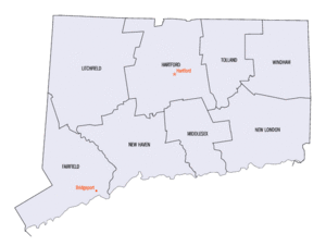
Connecticut has eight areas called counties. These counties are like big sections of the state.
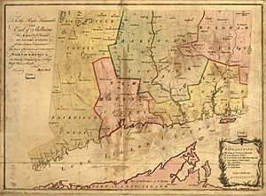
Four of these counties were created way back in 1666. This was soon after the Connecticut Colony and the New Haven Colony joined together. The other counties were added later. Many of them are named after places in England. This is because many early settlers in Connecticut came from there.
Even though Connecticut has counties, they don't have their own governments anymore. Most of the jobs that county governments used to do were stopped in 1960. The last county jobs, like county sheriffs, ended in 2000. Now, other state groups handle those tasks.
Today, counties are mostly used for things like maps, collecting state information, and for the court system.
New Ways to Organize the State
In 2019, Connecticut suggested a new idea to the United States Census Bureau. They wanted to use nine "Councils of Governments" instead of counties for collecting statistics. These councils are groups of towns that work together.
The Census Bureau agreed to this idea in 2022. This means that by 2024, these councils will be used for official statistics. The Census Bureau said that these councils can do many of the jobs that counties do in other states.
The Census Bureau also gave new codes to these planning regions. This helps show that they are different from the old county areas. Even though the new regions are similar to the old counties, they might include towns from different counties.
Counties in Alphabetical Order
Here is a list of Connecticut's counties, in alphabetical order. It shows when each county was created and how it got its name.
| County |
FIPS code | Seat | Est. | Origin | Etymology | Population | Area | Map |
|---|---|---|---|---|---|---|---|---|
| Fairfield County | 001 | Bridgeport | 1666 | original county | From the hundreds of acres of salt marsh that bordered the coast. | 959,768 | 626 sq mi (1,621 km2) |
 |
| Hartford County | 003 | Hartford | 1666 | original county | After Hertford, England (still said Hartford) | 896,854 | 736 sq mi (1,906 km2) |
 |
| Litchfield County | 005 | Litchfield | 1751 | From parts of Fairfield, Hartford and New Haven Counties | City of Lichfield, Staffordshire, England | 185,000 | 920 sq mi (2,383 km2) |
 |
| Middlesex County | 007 | Middletown | 1785 | From parts of Hartford and New London Counties | Former county of Middlesex, England | 164,759 | 369 sq mi (956 km2) |
 |
| New Haven County | 009 | New Haven | 1666 | original county | After New Haven Colony, founded as a haven in which Puritans could be free from persecution. | 863,700 | 606 sq mi (1,570 km2) |
 |
| New London County | 011 | New London | 1666 | original county | After London, England | 268,805 | 666 sq mi (1,725 km2) |
 |
| Tolland County | 013 | Rockville | 1785 | From parts of Hartford and Windham Counties | Hamlet of Tolland, Somerset, England | 150,293 | 410 sq mi (1,062 km2) |
 |
| Windham County | 015 | Willimantic | 1726 | From parts of Hartford and New London Counties | Either after Windham (now Wineham) in Sussex or Windham (now Wymondham, still said Windham) in Norfolk, England | 116,418 | 513 sq mi (1,329 km2) |
 |
Past Counties
Connecticut also had two other areas that were once considered counties, but they are no longer part of the state:
- Trumbull County, which is now in Ohio. It was given to Ohio in 1800.
- Westmoreland County, Connecticut near Wilkes-Barre, which is now in Pennsylvania. It was given to Pennsylvania in 1784.
See also
 In Spanish: Anexo:Condados de Connecticut para niños
 | William M. Jackson |
 | Juan E. Gilbert |
 | Neil deGrasse Tyson |


