Windham County, Connecticut facts for kids
Quick facts for kids
Windham County
|
|
|---|---|

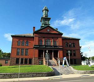
Windham Town Hall, a former county courthouse
|
|

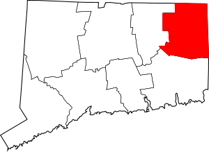
Location within the U.S. state of Connecticut
|
|
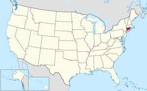
 Connecticut's location within the U.S. |
|
| Country | |
| State | |
| Founded | May 12, 1726 |
| Named for | Windham, England |
| Seat | none (1960-present)
Willimantic (1893–1960) Windham Center (1726–1893) |
| Largest town | Windham |
| Area | |
| • Total | 521 sq mi (1,350 km2) |
| • Land | 513 sq mi (1,330 km2) |
| • Water | 8.5 sq mi (22 km2) 1.6%% |
| Population
(2020)
|
|
| • Total | 116,418 |
| • Density | 223.5/sq mi (86.3/km2) |
| Time zone | UTC−5 (Eastern) |
| • Summer (DST) | UTC−4 (EDT) |
| Area code | 860 and 959 |
| Congressional district | 2nd |
Windham County (/ˈwɪndəm/ WIN-dəm) is one of the eight older counties in the U.S. state of Connecticut. You can find it in the northeastern part of the state. In 2020, about 116,418 people lived here. This makes it the county with the smallest population in Connecticut. Windham County is often called the "Quiet Corner" because of its peaceful, rural feel. The entire county is part of the Quinebaug and Shetucket Rivers Valley National Heritage Corridor. This area is special because of its natural beauty and history.
Contents
Discovering Windham County's Past
The land that is now Windham County became interesting to English settlers around 1635. However, it took over 50 years for people to settle there. This was because it was far from the coast. John Winthrop the Younger was very interested in this land. He bought land from the Narragansett people. In October 1671, he got permission from the Connecticut court to start a settlement.
In 1678, a piece of land called Joshua's Tract was given to Connecticut officials. Joshua was the son of a Mohegan chief named Uncas. In February 1682, this land was given to Samuel and Daniel Mason. Later, in 1684, the Nipmunk people sold 1200 acres of land to Jonathan Curtis, Thomas Dudley, and Samuel Mason, among others.
How Windham County Was Formed
Windham County was officially created on May 12, 1726. It was formed from parts of Hartford and New London counties. The Connecticut General Court made this decision. The act that created the county listed the towns that would be part of it. These included Windham, Lebanon, Plainfield, Canterbury, Mansfield, Coventry, Pomfret, Killingly, Ashford, Voluntown, and Mortlake.
Over the years, the borders of Windham County changed a few times. For example, in 1749, the town of Woodstock joined Windham County. Some towns moved to other counties, like Union, Coventry, and Lebanon. New towns were also created from the original county land. These new towns included Thompson, Brooklyn, Hampton, Sterling, Chaplin, Eastford, Putnam, and Scotland. The last change to the county's border happened in 1885.
Changes in County Government
On June 6, 2022, the U.S. Census Bureau made a big change. They decided to recognize Connecticut's nine councils of governments as county equivalents. This means they are now used for official statistics instead of the eight historical counties. Connecticut's county governments actually stopped working in 1960. The councils of governments took over some of their local duties. So, while Windham County still exists by name, it's no longer used for official government statistics.
Exploring Windham County's Landscape
Windham County covers a total area of about 521 square miles. Most of this is land, about 513 square miles. The rest, about 8.5 square miles, is water.
The highest point in Windham County is Snow Hill. It is located in Ashford and stands 1,210 feet tall.
Neighboring Areas
Windham County shares its borders with several other counties:
- Worcester County, Massachusetts (to the north)
- Providence County, Rhode Island (to the east)
- Kent County, Rhode Island (to the southeast)
- New London County (to the south)
- Tolland County (to the west)
Local Weather
| Month | Jan | Feb | Mar | Apr | May | Jun | Jul | Aug | Sep | Oct | Nov | Dec | Year |
|---|---|---|---|---|---|---|---|---|---|---|---|---|---|
| Record high °F (°C) | 69 (21) |
72 (22) |
82 (28) |
93 (34) |
95 (35) |
98 (37) |
100 (38) |
100 (38) |
100 (38) |
88 (31) |
80 (27) |
75 (24) |
100 (38) |
| Mean daily maximum °F (°C) | 35.3 (1.8) |
38.4 (3.6) |
47.3 (8.5) |
59.3 (15.2) |
70.1 (21.2) |
78.0 (25.6) |
82.3 (27.9) |
80.8 (27.1) |
73.8 (23.2) |
62.1 (16.7) |
51.9 (11.1) |
40.3 (4.6) |
60.0 (15.5) |
| Daily mean °F (°C) | 29.0 (−1.7) |
31.7 (−0.2) |
38.3 (3.5) |
48.1 (8.9) |
57.9 (14.4) |
67.7 (19.8) |
73.4 (23.0) |
72.1 (22.3) |
64.9 (18.3) |
54.0 (12.2) |
44.7 (7.1) |
34.7 (1.5) |
51.4 (10.8) |
| Mean daily minimum °F (°C) | 17.0 (−8.3) |
19.6 (−6.9) |
26.3 (−3.2) |
36.2 (2.3) |
45.9 (7.7) |
55.5 (13.1) |
61.0 (16.1) |
59.9 (15.5) |
51.4 (10.8) |
39.6 (4.2) |
31.4 (−0.3) |
22.3 (−5.4) |
38.8 (3.8) |
| Record low °F (°C) | −27 (−33) |
−21 (−29) |
−16 (−27) |
6 (−14) |
22 (−6) |
30 (−1) |
37 (3) |
32 (0) |
20 (−7) |
15 (−9) |
1 (−17) |
−18 (−28) |
−27 (−33) |
| Average precipitation inches (mm) | 3.36 (85) |
3.25 (83) |
4.32 (110) |
3.74 (95) |
3.49 (89) |
3.68 (93) |
3.43 (87) |
3.35 (85) |
3.44 (87) |
3.94 (100) |
3.99 (101) |
3.78 (96) |
43.77 (1,111) |
| Average snowfall inches (cm) | 8.1 (21) |
11.1 (28) |
5.5 (14) |
1.1 (2.8) |
0.0 (0.0) |
0.0 (0.0) |
0.0 (0.0) |
0.0 (0.0) |
0.0 (0.0) |
0.0 (0.0) |
0.9 (2.3) |
6.7 (17) |
33.4 (85.1) |
| Average precipitation days (≥ 0.1 in) | 6 | 6 | 7 | 7 | 8 | 7 | 6 | 5 | 6 | 6 | 6 | 7 | 72 |
| Average snowy days (≥ 0.1 in.) | 4 | 4 | 3 | 0 | 0 | 0 | 0 | 0 | 0 | 0 | 1 | 2 | 15 |
| Source: | |||||||||||||
Getting Around Windham County
Main Roads
Many important roads pass through Windham County. Interstate 395 goes north and south. It connects the county from Plainfield to the Massachusetts border at Thompson. The southern part of I-395 is also part of the Connecticut Turnpike. This road goes east and west from I-395 exit 35 to U.S. Route 6 at the Rhode Island border.
Other important roads that go north and south include Route 12. It runs next to I-395 through many towns. Route 169 is a special road called a National Scenic Byway. It travels through quiet, rural towns. Other north-south roads are Routes 89, 198, 97, 21, and 49.
Major roads that go east and west are U.S. Route 44 and U.S. Route 6. Route 44 goes from Ashford to the Rhode Island border at Putnam. Route 6 goes from Windham to the Rhode Island border at Killingly. Route 6 has short highway parts in Windham and Killingly. Other east-west roads include Routes 14, 101, 171, and 197.
Airports
Windham Airport is the main airport for the county. It is about three miles from Willimantic. Smaller airports include Woodstock Airport and Danielson Airport.
Bike Trails
Windham County has many bike paths for you to explore. The two main trails are the Air Line State Park Trail and the Hop River State Park Trail. Both of these trails enter the county through Windham. The Hop River Trail ends at the Air Line Trail. The Air Line Trail continues all the way into Putnam. Another part of the Air Line Trail is in Thompson. It continues to the Massachusetts border as the Southern New England Trunkline Trail.
Another shorter trail is the Moosup Valley State Park Trail. It starts in Plainfield and goes to the Rhode Island border. There, it becomes the Washington Secondary Rail Trail. Other smaller trails include the Quinebaug River Trail and the Putnam River Trail.
Keeping Windham County Safe
Most towns in Windham County are kept safe by the Connecticut State Police. Troop D, based in Danielson, helps towns like Brooklyn, Canterbury, Chaplin, Eastford, Hampton, Killingly, Pomfret, Putnam, Scotland, Sterling, Thompson, and Woodstock. They also patrol I-395. Troop C covers Ashford, and Troop K covers Windham.
Only three areas in the county have their own local police departments. These are the town of Plainfield, the Willimantic Special Services District, and the Putnam Special Services District. Eastern Connecticut State University in Willimantic also has its own police department. They keep the university campus safe.
The Windham County Sheriff's Department was closed in 2000. Their old jobs are now done by the Connecticut State Marshals Service. Many towns also have local Constables. These are officials who help with local legal and security tasks.
Population and People
| Historical population | |||
|---|---|---|---|
| Census | Pop. | %± | |
| 1790 | 28,881 | — | |
| 1800 | 28,222 | −2.3% | |
| 1810 | 28,611 | 1.4% | |
| 1820 | 31,684 | 10.7% | |
| 1830 | 27,082 | −14.5% | |
| 1840 | 28,080 | 3.7% | |
| 1850 | 31,081 | 10.7% | |
| 1860 | 34,747 | 11.8% | |
| 1870 | 38,518 | 10.9% | |
| 1880 | 43,856 | 13.9% | |
| 1890 | 45,158 | 3.0% | |
| 1900 | 46,861 | 3.8% | |
| 1910 | 48,361 | 3.2% | |
| 1920 | 52,815 | 9.2% | |
| 1930 | 54,086 | 2.4% | |
| 1940 | 56,223 | 4.0% | |
| 1950 | 61,759 | 9.8% | |
| 1960 | 68,572 | 11.0% | |
| 1970 | 84,515 | 23.3% | |
| 1980 | 92,312 | 9.2% | |
| 1990 | 102,525 | 11.1% | |
| 2000 | 109,091 | 6.4% | |
| 2010 | 118,428 | 8.6% | |
| 2020 | 116,418 | −1.7% | |
| U.S. Decennial Census 1790-1960 1900-1990 1990-2000 2010-2018 |
|||
In 2010, there were 118,428 people living in Windham County. There were about 44,810 households. A household is a group of people living together. The population density was about 230 people per square mile. Most people (89.6%) were white. About 9.6% of the population was of Hispanic or Latino origin.
About 32.6% of households had children under 18 living with them. The average household had 2.54 people. The average family had 3.01 people. The median age in the county was 39.2 years old.
The median income for a household was $59,370. This means half of the households earned more than this, and half earned less. For families, the median income was $69,642. About 11.4% of the population lived below the poverty line. This included 16.0% of those under 18.
Towns and Their Incomes
Here is a look at the income levels in different towns within Windham County, based on 2010 data:
| Rank | Town | Per capita income |
Median household income |
Median family income |
Population | Number of households |
|
|---|---|---|---|---|---|---|---|
| 1 | Eastford | Town | $36,784 | $76,786 | $93,295 | 1,749 | 690 |
| 2 | Woodstock | Town | $36,342 | $74,000 | $88,737 | 7,964 | 3,151 |
| 3 | Hampton | Town | $34,642 | $79,943 | $84,079 | 1,863 | 747 |
| 4 | Pomfret | Town | $33,910 | $68,278 | $82,917 | 4,247 | 1,582 |
| 5 | Ashford | Town | $32,842 | $69,407 | $79,157 | 4,317 | 1,716 |
| 6 | Chaplin | Town | $32,188 | $62,679 | $72,426 | 2,305 | 920 |
| 7 | Canterbury | Town | $30,453 | $70,902 | $84,093 | 5,132 | 1,934 |
| 8 | Scotland | Town | $29,371 | $75,417 | $79,722 | 1,726 | 637 |
| 9 | Thompson | Town | $27,222 | $60,951 | $74,613 | 9,458 | 3,730 |
| 10 | Putnam | Town | $26,506 | $51,180 | $61,168 | 9,584 | 3,950 |
| 11 | Sterling | Town | $25,557 | $64,500 | $74,405 | 3,830 | 1,383 |
| 12 | Killingly | Town | $25,215 | $53,192 | $65,496 | 17,370 | 6,749 |
| 13 | Brooklyn | Town | $25,124 | $68,851 | $76,224 | 8,210 | 2,989 |
| 14 | Plainfield | Town | $24,825 | $61,500 | $69,096 | 15,405 | 5,726 |
| 15 | Danielson | Borough | $22,798 | $55,097 | $56,831 | 4,051 | 1,627 |
| 16 | Windham | Town | $20,272 | $40,063 | $48,145 | 25,268 | 8,906 |
Towns and Villages in Windham County
Boroughs are parts of towns that have their own local governments. Villages are just names for places, but they don't have their own separate governments.
Education in Windham County
Here are the school districts in Windham County:
Schools for All Grades (K-12)
- Killingly School District
- Plainfield School District
- Putnam School District
- Thompson School District
- Windham School District
High Schools
- Regional High School District 19
- Regional High School District 11
Elementary Schools
- Ashford School District
- Brooklyn School District
- Canterbury School District
- Chaplin School District
- Eastford School District
- Hampton School District
- Pomfret School District
- Scotland School District
- Sterling School District
- Woodstock School District
There is also Woodstock Academy. This is a private high school that gets public funding.
See also
 In Spanish: Condado de Windham (Connecticut) para niños
 | Selma Burke |
 | Pauline Powell Burns |
 | Frederick J. Brown |
 | Robert Blackburn |


