
Air Line State Park Trail facts for kids
Quick facts for kids Air Line State Park Trail |
|
|---|---|

Air Line Trail northeast of Black Spruce Pond in Hampton, CT (Pine Acres Lake View Trail intersection near Goodwin Conservation Center)
|
|
| Lua error in Module:Location_map at line 420: attempt to index field 'wikibase' (a nil value). | |
| Location | Connecticut, United States |
| Area | 40 acres (16 ha) |
| Established | 1969 |
| Governing body | Connecticut Department of Energy and Environmental Protection |
| Website | Air Line State Park Trail |
The Air Line State Park Trail is a cool path in Connecticut. It's built on an old railroad line! This trail is a "linear state park," meaning it's long and narrow. It's perfect for walking, biking, and even horseback riding. The trail is split into different parts. These parts connect towns like East Hampton, Windham, and Putnam. There's even a part that goes all the way to the Massachusetts border! In 2002, the southern part of the trail was named a national recreation trail. This shows how special it is!
Contents
History of the Air Line Trail
The Old "Air Line" Railroad
Imagine a super-fast train line from New York to Boston! That was the idea behind the "Air Line" railroad. It got its name because it was built to be very straight. This meant building huge bridges called viaducts. These bridges helped the trains travel fast and smoothly.
The railroad opened in 1873. It connected New Haven to Willimantic. Sadly, the company went bankrupt soon after. But the line was later taken over by another railroad.
Today, parts of the old railroad are still used. Some sections are active train tracks. Other parts, like the one in Willimantic, have museums. Here you can see old train buildings. The most famous parts are the Rapallo Viaduct and the Lyman Viaduct. These are two of the longest railroad bridges in the whole U.S.!

Turning Rails into Trails
Most of the old railroad line was no longer used. So, the state of Connecticut bought it. They decided to turn it into a public trail! This started in 1969. The first part of the trail opened for people to ride horses.
Over the years, more and more sections were opened. In 1986, the southern part became a trail. The section in Thompson opened in 1992. In 2015, a new bridge opened over the Willimantic River. This connected even more parts of the trail.
The Air Line State Park Trail has three main sections:
- South section: This runs from East Hampton to Windham.
- North section: This goes from Windham to Putnam.
- Thompson section: This part stretches from Thompson to the Massachusetts state line.
The North section is even part of the East Coast Greenway. This is a huge trail that will go all the way from Florida to Maine!
Making the Trail Longer
The trail has been growing over time. People wanted to extend it further south. They wanted to connect it to downtown Portland.
In 1999, students from the United States Coast Guard Academy helped build a bridge. This bridge helped extend the trail. More sections were added in 2011 and 2012. These new parts brought the trail right into downtown East Hampton.
Later, grants helped fund more extensions. In 2017, a new section opened from Main Street to Aldens Crossing. More work continued to connect the trail to the town line. In 2018, a new part of the trail opened in Portland. This section is 2.3 miles long. It connects to the trail from East Hampton.
Future plans include extending the trail even more. It might reach downtown Portland. It could even go along the Connecticut River to Glastonbury!
South Section of the Trail
What the South Section is Like
This part of the trail is finished and ready to use. It has a smooth surface made of packed stone dust. You'll find benches in pretty spots where you can rest. There are also bike racks.
New bridges built by students from the U.S. Coast Guard Academy cross rivers like the Blackledge and Jeremy. You'll also cross the famous Rapallo and Lyman Viaducts. These are huge bridges that carried the old railroad. Now they carry the trail across wide valleys. There's one small detour where the trail goes onto a road for a short distance.
Willimantic River to Bridge Street
This part has a wooden path over the Willimantic River. It uses the old railroad bridge for support. After the bridge, the trail becomes paved. It meets the Hop River State Park Trail here. You'll see a sign telling you about both trails' history.
The trail then goes past the Connecticut Eastern Railroad Museum. It leads to the trailhead near Bridge Street. This section can be a bit noisy. It's close to an active freight train line.
Where to Access the South Section
The trail crosses many roads. These crossings offer places to get onto the trail. Some have parking areas.
| County | Town | Street | Coordinates | |
|---|---|---|---|---|
| Middlesex | East Hampton | municipal parking area, railroad bridge | 41°34′32″N 72°30′01″W / 41.5755°N 72.5004°W | |
| Watrous Street | ||||
| Smith Street | parking area | 41°34′42″N 72°29′33″W / 41.5782°N 72.4924°W | ||
| New London | Colchester | Bull Hill Road | parking area | 41°33′56″N 72°26′35″W / 41.5655°N 72.4430°W |
| River Road | parking area; railroad bridge | 41°34′50″N 72°25′30″W / 41.5805°N 72.4249°W | ||
| River Road | ||||
| parking area | 41°35′06″N 72°24′00″W / 41.5850°N 72.4000°W | |||
| Tolland | Hebron | On road: under |
||
| Old Hartford Road | parking area | 41°35′30″N 72°23′29″W / 41.5918°N 72.3914°W | ||
| Jeremy River | river crossing | 41°35′54″N 72°22′37″W / 41.5983°N 72.3769°W | ||
| Grayville Road | parking area | 41°36′53″N 72°21′59″W / 41.6147°N 72.3664°W | ||
| Old Colchester Road | parking area | 41°37′13″N 72°21′35″W / 41.6204°N 72.3598°W | ||
| parking area | 41°37′56″N 72°20′37″W / 41.6322°N 72.3437°W | |||
| North Pond Road | 41°38′01″N 72°20′35″W / 41.6336°N 72.3430°W | |||
| parking area | 41°38′23″N 72°20′22″W / 41.6397°N 72.3395°W | |||
| New London | Lebanon | Leonard Bridge Road | parking area | 41°39′09″N 72°18′12″W / 41.6525°N 72.3032°W |
| Chesbro Bridge Road | parking area | 41°39′46″N 72°17′25″W / 41.6629°N 72.2902°W | ||
| Tolland | Columbia | 41°40′27″N 72°16′05″W / 41.6742°N 72.2681°W | ||
| New London | Lebanon | Cook Hill Road | parking area | 41°41′07″N 72°15′54″W / 41.6852°N 72.2651°W |
| Village Hill Road | parking area | 41°41′50″N 72°15′04″W / 41.6973°N 72.2511°W | ||
| Kingsley Road | parking area | 41°42′31″N 72°14′30″W / 41.7085°N 72.2418°W | ||
| County Line | Town Line | Willimantic River | river crossing | 41°42′48″N 72°14′16″W / 41.7134°N 72.2379°W |
| Windham | Windham | Paved Section begins | 41°42′50″N 72°14′15″W / 41.7138°N 72.2375°W | |
| Hop River State Park Trail | leads to Bolton and
Hartford area |
|||
| Bridge Street ( |
Opened in 2015, parking area | 41°42′44″N 72°13′23″W / 41.7122°N 72.2230°W | ||
North Section of the Trail
What the North Section is Like
This section is open to everyone. However, different parts are in different stages of being finished. Some parts are smooth with signs. Other parts are cleared but still a bit rough. They might not be good for road bikes. Some areas are still wild and overgrown.
Good news: there are no big missing bridges on this section. Even though some parts are not fully developed, this area doesn't have as many river crossings as the southern section.
The trail continues west of Route 66. It becomes the Veterans Greenway. This is a town-owned bike path that leads to downtown Willimantic.
Windham to Hampton
This part has been improved a lot recently. The first quarter-mile is paved. The state and towns have cleared, leveled, and added signs. They also put down a smooth stone-dust surface. A new trail bridge was built over Boulevard Road.

Hampton to Pomfret
This section was cleared by the National Guard in the 1990s. The surface isn't fully finished. Some parts are rough, and some areas can flood. There hasn't been much upkeep lately. So, some cleared areas have grown in a bit. Still, it's good for hikers, horseback riders, and mountain bikers. There are plans to add signs and finish the surface.
Pomfret to Putnam
This part of the trail is still undeveloped. It hasn't been cleared and is very overgrown. The surface is rough. There are fallen trees and wet spots. You might have to climb up hills to cross roads where old bridges used to be. It's really only for walking if you try it.
There are plans to clear and improve this section. A big project is underway with a budget of $5.5 million. They plan to build two new pedestrian bridges. They will also fix drainage issues. This work is expected to finish in Fall 2020.
Where to Access the North Section
The trail crosses many roads. These crossings offer places to get onto the trail. Some have parking areas.
| County | Town | Street | Coordinates | |
|---|---|---|---|---|
| Windham | Windham | Union Street | Terminus | 41°42′40″N 72°12′31″W / 41.7112°N 72.2087°W |
| Milk Street | parking area | 41°42′45″N 72°12′23″W / 41.7124°N 72.2064°W | ||
| Valley Street | 41°42′45″N 72°12′22″W / 41.7125°N 72.2062°W | |||
| 41°43′08″N 72°11′58″W / 41.7190°N 72.1994°W | ||||
| Natchaug River | river crossing | 41°43′17″N 72°11′49″W / 41.7213°N 72.1970°W | ||
| Private Drive | 41°43′49″N 72°11′10″W / 41.7303°N 72.1861°W | |||
| 41°43′56″N 72°11′05″W / 41.7322°N 72.1848°W | ||||
| Next to road: Tuckie Road | No junction | |||
| End of the Veterans' Memorial Greenway (improved section begins) | 41°44′06″N 72°10′46″W / 41.7349°N 72.1795°W | |||
| 41°44′46″N 72°09′22″W / 41.7462°N 72.1560°W | ||||
| Boulevard Road | 41°44′56″N 72°09′07″W / 41.7488°N 72.1520°W | |||
| Tolland | Chaplin | Chewink Road | parking area | 41°45′05″N 72°07′15″W / 41.7515°N 72.1208°W |
| Windham | Hampton | South Brook Street | Shared Intersection | 41°45′56″N 72°05′39″W / 41.7656°N 72.0942°W |
| Parker Road | ||||
| Overpass - no connection | 41°46′09″N 72°05′26″W / 41.7692°N 72.0905°W | |||
| Potter Road | parking:
Goodwin Conservation Center |
41°46′40″N 72°05′12″W / 41.7777°N 72.0866°W | ||
| Estabrooks Road | 41°47′55″N 72°05′27″W / 41.7987°N 72.0908°W | |||
| Station Road | 41°48′27″N 72°04′12″W / 41.8074°N 72.0701°W | |||
| Griffin Road | 41°49′11″N 72°03′58″W / 41.8196°N 72.0661°W | |||
| Little River | river crossing | 41°49′20″N 72°03′26″W / 41.8223°N 72.0571°W | ||
| Kenyon Road | parking area | 41°49′21″N 72°03′23″W / 41.8225°N 72.0563°W | ||
| Lewis Road | 41°49′37″N 72°02′29″W / 41.8270°N 72.0414°W | |||
| Pomfret | 41°50′01″N 72°01′09″W / 41.8336°N 72.0192°W | |||
| Brooklyn Road | 41°50′03″N 72°00′45″W / 41.8343°N 72.0126°W | |||
| underpass/no access | 41°51′33″N 71°59′59″W / 41.8593°N 71.9998°W | |||
| Covell Road | 41°51′46″N 71°59′31″W / 41.8628°N 71.9919°W | |||
| Babbitt Hill Road | 41°51′51″N 71°59′00″W / 41.8641°N 71.9832°W | |||
|
parking area | 41°52′04″N 71°57′40″W / 41.8678°N 71.9611°W | ||
| Needles Eye Road | 41°52′29″N 71°56′59″W / 41.8746°N 71.9496°W | |||
| Wright's Crossing Road | 41°52′39″N 71°56′31″W / 41.8776°N 71.9420°W | |||
| Unimproved Section begins | ||||
| Holmes Road | 41°52′56″N 71°56′04″W / 41.8823°N 71.9344°W | |||
| Putnam | Modock Road | 41°53′09″N 71°55′19″W / 41.8857°N 71.9219°W | ||
| River Road | 41°53′22″N 71°54′51″W / 41.8895°N 71.9141°W | |||
| Town Farm Road | 41°53′37″N 71°54′37″W / 41.8936°N 71.9104°W | |||
| Private Road | 41°54′28″N 71°54′29″W / 41.9078°N 71.9080°W | |||
| Quinebaug River | river crossing | 41°54′28″N 71°54′29″W / 41.9079°N 71.9080°W | ||
| Kennedy Drive | Terminus | 41°54′30″N 71°54′29″W / 41.9084°N 71.9080°W | ||
Thompson Section of the Trail
What the Thompson Section is Like
A lot of work is being done to improve this part of the trail. The old train tracks have been removed. The trail surface is being leveled. Drainage is also being improved. When finished, the surface will be hard-packed dirt and gravel.
The trail is mostly clear of big obstacles. There is one missing bridge over a creek. You'll need to take a short detour on a path next to it. New parking areas have been built. These are at places where the trail crosses roads. You'll find signs and information kiosks there too.
As of 2017, the northern part of this section is not yet improved.
Where to Access the Thompson Section
The trail crosses many roads. These crossings offer places to get onto the trail. Some have parking areas.
| County | Town | Street | Coordinates | |
|---|---|---|---|---|
| Windham | Thompson | Terminus (south of Thompson center) | 41°56′51″N 71°53′06″W / 41.9475°N 71.8851°W | |
| Bridge over ramps - no connection | 41°57′17″N 71°52′51″W / 41.9547°N 71.8809°W | |||
| Overpass - no connection | 41°58′01″N 71°52′26″W / 41.9669°N 71.8740°W | |||
| Sunset Hill Road | 41°58′35″N 71°51′57″W / 41.9764°N 71.8658°W | |||
| Lowell Davis Road | 41°59′05″N 71°51′24″W / 41.9846°N 71.8566°W | |||
| Overpass - no connection | 41°59′14″N 71°51′11″W / 41.9873°N 71.8531°W | |||
| Overpass - no connection (north of Thompson center) | 41°59′34″N 71°50′38″W / 41.9929°N 71.8438°W | |||
| Sand Dam Road | 42°00′16″N 71°49′12″W / 42.0045°N 71.8201°W | |||
| East Thompson Road | Connection with Southern New England Trunkline Trai | 42°00′32″N 71°48′33″W / 42.0089°N 71.8091°W |
The trail continues east and north into Massachusetts. It becomes the Southern New England Trunkline Trail. This is part of the Massachusetts State Park System.
Colchester Spur Trail
What the Colchester Spur is Like
This shorter trail is about 3.6 miles long. It has the same hard-packed gravel surface as the main South section. When you cross Route 85, there's a marked crosswalk. Other crossings are over smaller local roads without marks. The trail ends just east of downtown Colchester. It stops at the old train station and freight house.
Where to Access the Colchester Spur
The trail crosses these roads, providing access points:
| County | Town | Street | Coordinates | |
|---|---|---|---|---|
| Tolland | Hebron | 41°37′11″N 72°20′39″W / 41.6196°N 72.3441°W | ||
| Crouch Road | 41°36′50″N 72°20′34″W / 41.6139°N 72.3428°W | |||
| New London | Colchester | Old Amston Road | 41°35′41″N 72°20′01″W / 41.5947°N 72.3335°W | |
| Terminus | 41°34′46″N 72°19′38″W / 41.5795°N 72.3273°W |
Images for kids
-
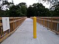
The Airline Trail South bridge over the Willimantic River
-
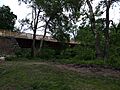
The bridge from the Hop River Trail


See Also
