
Glastonbury, Connecticut facts for kids
Quick facts for kids
Glastonbury, Connecticut
|
||
|---|---|---|
|
Town
|
||
| Town of Glastonbury | ||

First Church of Christ
|
||
|
||
 Hartford County and Connecticut Hartford County and Connecticut Capitol Planning Region and Connecticut Capitol Planning Region and Connecticut |
||
| Country | ||
| U.S. state | ||
| County | Hartford | |
| Region | Capitol Region | |
| Settled | 1636 | |
| Incorporated | 1693 | |
| Communities | Glastonbury Addison Buckingham East Glastonbury Hopewell South Glastonbury Welles Village |
|
| Government | ||
| • Type | Council-manager | |
| Area | ||
| • Total | 52.2 sq mi (135.2 km2) | |
| • Land | 51.3 sq mi (132.8 km2) | |
| • Water | 0.9 sq mi (2.4 km2) | |
| Elevation | 417 ft (127 m) | |
| Population
(2020)
|
||
| • Total | 35,159 | |
| • Density | 673.53/sq mi (260.05/km2) | |
| Time zone | UTC-5 (Eastern) | |
| • Summer (DST) | UTC-4 (Eastern) | |
| ZIP Codes |
06025, 06033, 06073
|
|
| Area code(s) | 860/959 | |
| FIPS code | 09-31240 | |
| GNIS feature ID | 0213432 | |
| Major Highways | ||

Glastonbury is a town in Connecticut, United States. It was officially started in 1693, but people first settled there in 1636. The town got its name from Glastonbury in Somerset, England. Glastonbury is located along the Connecticut River, about 7 miles (11 km) southeast of Hartford. In 2020, about 35,159 people lived in Glastonbury.
Contents
History of Glastonbury
In 1636, about 30 families settled in an area called Pyaug. This land was bought from a Native American chief named Sowheag. Pyaug was part of Wethersfield at the time.
In 1672, the government allowed Pyaug's boundary to extend 5 miles (8 km) to the east. By 1690, Pyaug residents were allowed to form their own town, and so Glassenbury was created in 1693.
Even today, there's a special connection to the past: the oldest continuously running ferry in the United States still operates between South Glastonbury and Rocky Hill. This ferry has been running since 1655!
During the American Revolutionary War, some homes in Glastonbury were used to hold classes for Yale University. Noah Webster, who later created the famous dictionary, was a student and teacher here.
Glassenbury was ahead of its time. It freed its enslaved people in the 1780s, which was 60 years before Connecticut officially ended slavery. The town also started its first library in 1803 and an early hospital to treat smallpox after the Revolution. By the end of the Revolution, there were ten schools in town.
In 1785, the town's name changed from Glassenbury to Glastenbury. In the 1700s and early 1800s, Glastenbury was a busy shipbuilding town. It had good waterpower and lots of oak trees nearby. Sawmills and foundries grew around the shipyards.
As shipbuilding slowed down, new industries began. The J.B. Williams Soap Factory started in 1840. James B. Williams made shaving soap and later moved his business to Glastenbury. He and his brother created what is thought to be the world's first commercial soap company. They made products like Williams 'Lectric Shave and Aqua Velva. The company grew and opened branches in other countries. Today, J. B. Williams Park is named after James B. Williams.
In 1870, the town's name changed again, from Glastenbury to Glastonbury, to match Glastonbury, England. During the World Wars, Glastonbury factories made leather and woolen goods for the military. The town also had mills for feldspar, cotton, and paper, as well as silver plate factories and even an airplane building industry.
J.H. Hale Orchards started in 1866. John Howard Hale became known as the "Peach King" because he developed a special peach that could survive New England winters. He was also a pioneer in selling peaches across the country. His orchard grew from 1 acre (0.004 km2) in 1866 to over 1,200 acres (4.9 km2) by 1900. John Howard Hale also helped start the University of Connecticut.
Henry Saglio began a project to breed a white chicken. In 1948, the Saglio Brothers formed Arbor Acres and created a special broiler chicken that was very popular. By 1958, Arbor Acres was selling chickens all over the world.
Glastonbury was also a big grower of tobacco. Today, this farming tradition continues with orchards and berry farms on the town's hills.
In 1993, musician Billy Joel filmed parts of his music video for "The River of Dreams" in a barn in South Glastonbury. The video also shows the Rocky Hill-Glastonbury Ferry.
Geography and Climate
Glastonbury covers about 52.2 square miles (135.2 km2). Most of this is land, with a small amount of water. The town starts at the Connecticut River and goes up into hills. From some of these hills, you can see the skyline of Hartford.
A part of Glastonbury is called Kongscut Mountain, also known as Rattlesnake Mountain. It has a small number of timber rattlesnakes, but because the area is mostly state forest and not very developed, they don't pose a big threat.
The town has a small private lake called Diamond Lake. Glastonbury also has one of the largest state forests, Meshomasic State Forest, which is a great place for hiking, fishing, and hunting.
Glastonbury shares borders with several other towns and cities, including East Hartford, Wethersfield, Rocky Hill, Cromwell, Portland, East Hampton, Marlborough, Hebron, Bolton, and Manchester.
Climate in Glastonbury
Glastonbury has a humid continental climate. This means it has warm, humid summers and cold winters. The higher, rural parts of town can be a bit colder.
| Climate data for Glastonbury, Connecticut | |||||||||||||
|---|---|---|---|---|---|---|---|---|---|---|---|---|---|
| Month | Jan | Feb | Mar | Apr | May | Jun | Jul | Aug | Sep | Oct | Nov | Dec | Year |
| Record high °F (°C) | 70 (21) |
74 (23) |
86 (30) |
93 (34) |
99 (37) |
100 (38) |
101 (38) |
102 (39) |
101 (38) |
89 (32) |
83 (28) |
75 (24) |
102 (39) |
| Mean daily maximum °F (°C) | 36 (2) |
39 (4) |
48 (9) |
60 (16) |
70 (21) |
79 (26) |
84 (29) |
82 (28) |
75 (24) |
63 (17) |
52 (11) |
41 (5) |
61 (16) |
| Mean daily minimum °F (°C) | 18 (−8) |
22 (−6) |
29 (−2) |
40 (4) |
49 (9) |
59 (15) |
65 (18) |
63 (17) |
54 (12) |
43 (6) |
35 (2) |
24 (−4) |
42 (5) |
| Record low °F (°C) | −17 (−27) |
−24 (−31) |
−4 (−20) |
11 (−12) |
25 (−4) |
39 (4) |
45 (7) |
38 (3) |
29 (−2) |
18 (−8) |
5 (−15) |
−12 (−24) |
−24 (−31) |
| Average precipitation inches (mm) | 3.15 (80) |
2.75 (70) |
3.57 (91) |
3.88 (99) |
3.88 (99) |
3.99 (101) |
4.00 (102) |
3.66 (93) |
3.48 (88) |
4.14 (105) |
3.84 (98) |
3.35 (85) |
43.7 (1,110) |
| Source: The Weather Channel (Historical Monthly Averages) | |||||||||||||
Communities in Glastonbury
Glastonbury is made up of several smaller communities:
- Addison
- Buckingham
- East Glastonbury
- Glastonbury Center
- Hopewell
- South Glastonbury
Population and People
| Historical population | |||
|---|---|---|---|
| Census | Pop. | %± | |
| 1820 | 3,114 | — | |
| 1840 | 3,007 | — | |
| 1850 | 3,390 | 12.7% | |
| 1860 | 3,363 | −0.8% | |
| 1870 | 3,560 | 5.9% | |
| 1880 | 3,580 | 0.6% | |
| 1890 | 3,457 | −3.4% | |
| 1900 | 4,260 | 23.2% | |
| 1910 | 4,796 | 12.6% | |
| 1920 | 5,592 | 16.6% | |
| 1930 | 5,783 | 3.4% | |
| 1940 | 6,632 | 14.7% | |
| 1950 | 8,818 | 33.0% | |
| 1960 | 14,497 | 64.4% | |
| 1970 | 20,651 | 42.5% | |
| 1980 | 24,327 | 17.8% | |
| 1990 | 27,901 | 14.7% | |
| 2000 | 31,876 | 14.2% | |
| 2010 | 34,427 | 8.0% | |
| 2020 | 35,159 | 2.1% | |
| U.S. Decennial Census 2020 | |||
In 2020, Glastonbury had 35,159 people living there. Most residents were White (82.8%), with 9.1% Asian, 4.1% from two or more races, 1.7% African American, and 0.2% Native American. About 7.6% of the population was Hispanic or Latino.
About 20.8% of the population was under 18 years old, and 20.0% were 65 or older. Women made up 51% of the population. In 2024, the average household income in Glastonbury was about $140,836.
Economy and Jobs
Glastonbury has many businesses that provide jobs for its residents. Here are some of the top employers in town:
| # | Employer | # of Employees |
|---|---|---|
| 1 | Healthtrax Inc. | 1000–4999 |
| 2 | Open Solutions | 250–499 |
| 3 | Glastonbury High School | 250–499 |
| 4 | Glastonbury Town Hall | 250–499 |
| 5 | GM2 Associates Inc | 100–249 |
| 6 | The Home Depot | 100–249 |
| 7 | Stop & Shop | 100–249 |
| 8 | Glastonbury Healthcare Ctr | 100–249 |
| 9 | Salmon Brook Health and Rehab | 100–249 |
| 10 | Smith Brothers Insurance LLC | 100–249 |
Arts and Culture
Historical Houses
Glastonbury has many old houses. It has the second-highest number of genuine colonial houses (built before 1800) of any town in the U.S., with 154 such homes. Only Marblehead, Massachusetts, has more. Four houses in Glastonbury were built in the 1600s.
The oldest house in town, the John Hollister House, was built around 1675. It is one of the five oldest houses in Connecticut and one of the oldest in the entire country!
Town Events and Activities
One of the most popular events in Glastonbury is the CT River Valley Chamber of Commerce Apple Harvest & Music Festival, also known as "Apple Fest." This festival happens every October during apple harvest season. It lasts three days and includes live music, a 5K race, rides, attractions, and vendors selling handmade crafts.
Other fun events include the Under a Strawberry Moon Festival in June and various activities organized by the Town Center Initiative. The Glastonbury Youth and Family Services also puts on drama productions and family events each year.
For sports lovers, the Glastonbury River Runners club organizes three 5K races. The annual Glastonbury Art Walk displays local artists' work in businesses around the town center.
Glastonbury also has several shopping plazas with stores and restaurants, like Eric Town Square and Somerset Square. Many residents enjoy visiting the orchards in South Glastonbury, especially along Matson Hill Road. Here, you can pick your own fresh fruits like blueberries and pumpkins. In winter, some places sell Christmas trees.
Parks and Recreation
Glastonbury has several private clubs with pools and tennis courts, including Minnechaug, Orchard Hill, Woodledge, and Pinebrook. There's also a private golf course called Glastonbury Hills Country Club. The town also owns a nine-hole golf course called Minnechaug Golf Course.
Public places to swim include the Grange pool, Eastbury Pond, an indoor pool at Glastonbury High School, and a pool at Addison Park.
Cotton Hollow Nature Preserve in South Glastonbury is a beautiful place for fishing and hiking. It covers 80 acres (0.32 km2) and used to have several mills in the 18th and 19th centuries. You can still see the ruins of a cotton mill built in 1814. A stream called Roaring Brook runs through the preserve.
Glastonbury is also home to many other parks for residents to enjoy, such as Addison Park, Blackledge Falls, Buckingham Park, Butler Field, Center Green, Earle Park, Ferry Landing, Great Pond Reserve, Hubbard Green, Riverfront Park, Salmon Brook Park, Shoddy Mill Preserve, and J.B. Williams Park.
Education in Glastonbury
Glastonbury has five elementary schools: Buttonball Lane School, Hebron Avenue School, Hopewell School, Naubuc School, and Nayaug School. Each school has between 288 and 608 students.
There are two middle schools: Gideon Welles School for 6th graders (about 500 students) and Smith Middle School for 7th and 8th graders (about 1,035 students). The town's high school, Glastonbury High School, had 2,173 students in 2013.
Glastonbury's school system was even mentioned in an episode of the radio show This American Life.
Transportation

- Highways: Connecticut Route 2 is a major highway in Glastonbury with six exits. Connecticut Route 3 has one exit in Glastonbury and then crosses the Putnam Bridge to Wethersfield. Connecticut Route 17 has two exits in Glastonbury.
- Buses: Connecticut Transit (CT Transit) buses serve Glastonbury. The 95 route goes between downtown Hartford and Glastonbury. The 91 route travels between Wethersfield and Manchester. There's also a 904-Glastonbury Express route for commuters.
- Ferry: The Rocky Hill–Glastonbury ferry operates from May 1 to October 31. It is the oldest continuously running ferry in the U.S., dating back to 1655. The trip across the Connecticut River takes about four minutes. It costs $5 for a vehicle and $1 for people walking or on bikes.
Notable People from Glastonbury
Many interesting people have connections to Glastonbury:
- Amy Brenneman, actress
- Bob Backlund, professional wrestler
- Samuel J. Battle, the first Black police officer in the NYPD
- Candace Bushnell, author and TV producer
- Zandra Flemister, first African-American woman United States Secret Service agent
- William Hoyt, gold medalist in the 1896 Summer Olympics
- Laura Ingraham, conservative television host
- Roy Nutt, co-creator of Fortran (a computer programming language)
- Helen Maria Roser, nurse and educator
- Smiths of Glastonbury, five sisters active in women's suffrage and abolition movements in the 1800s
- Ocean Vuong, poet, essayist, and novelist
- Gideon Welles, Secretary of the Navy under Abraham Lincoln
- Thomas Welles, governor of Connecticut in 1658 and 1659
- Denny Zimmerman, racing driver
Images for kids
-
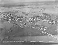
Flood of the Connecticut River, 1930
-
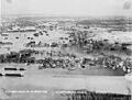
Flood of the Connecticut River, 1930
.jpg)
.jpg)
See also
 In Spanish: Glastonbury (Connecticut) para niños
