
East Hampton, Connecticut facts for kids
Quick facts for kids
East Hampton, Connecticut
|
|||
|---|---|---|---|
| Town of East Hampton | |||

Congregational Church of East Hampton
|
|||
|
|||
| Nickname(s):
Belltown, USA
|
|||
 Middlesex County and Connecticut Middlesex County and Connecticut Lower Connecticut River Valley Planning Region and Connecticut Lower Connecticut River Valley Planning Region and Connecticut |
|||
| Country | |||
| U.S. state | |||
| County | Middlesex | ||
| Region | Lower CT River Valley | ||
| Incorporated | 1767 | ||
| Government | |||
| • Type | Council-manager | ||
| Area | |||
| • Total | 36.8 sq mi (95.3 km2) | ||
| • Land | 35.6 sq mi (92.2 km2) | ||
| • Water | 1.2 sq mi (3.2 km2) | ||
| Elevation | 417 ft (127 m) | ||
| Population
(2020)
|
|||
| • Total | 12,717 | ||
| • Density | 357/sq mi (137.9/km2) | ||
| Time zone | UTC-5 (Eastern) | ||
| • Summer (DST) | UTC-4 (Eastern) | ||
| ZIP code |
06424, 06414, 06456
|
||
| Area code(s) | 860/959 | ||
| FIPS code | 09-22490 | ||
| GNIS feature ID | 0213423 | ||


East Hampton is a town located in Middlesex County, Connecticut, United States. It's part of the Lower Connecticut River Valley Planning Region. In 2020, about 12,717 people lived there. The main part of town, called the town center village, is also known as a census-designated place (CDP). East Hampton includes smaller areas like Cobalt, Middle Haddam, and Lake Pocotopaug.
You can find some cool outdoor spots in East Hampton! The southern end of the Shenipsit Trail is in Cobalt. The Airline State Park, which is a path built on an old railroad line, starts in East Hampton's Village Center. The town is also home to Hurd State Park, Meshomasic State Forest, and Salmon River State Forest. Don't miss Comstock's Bridge, also known as the Comstock Covered Bridge. It's the only covered bridge left in eastern Connecticut and crosses the Salmon River near Route 16.
If you're interested in history, you can visit the Chatham Historical Society Museum and the Joseph N. Goff House Museum and Cultural Center in town.
Contents
History of East Hampton
Early Settlers and Naming
The first European settlers came to this area in 1739. They traveled by sea from Eastham, Massachusetts, and then went up the Connecticut River. Some of these settlers, led by Isaac Smith, settled near Lake Pocotopaug, which is where East Hampton is today.
In 1746, they named their new community Easthampton parish, remembering their old home. Later, in 1767, the community became its own town, separate from Middletown. It was named Chatham, possibly because both Chatham and this area were important for shipbuilding.
The Belltown Era
An early iron factory near Lake Pocotopaug helped local needs and the shipbuilding industry. Over time, the skills learned from working with iron were used to make other things, like waffle irons! But the most famous product from East Hampton became bells.
In the 1800s, East Hampton became the main place for making bells. So many bells were made here that the town earned the nickname Belltown. The very first bell factory was built in 1808 by William Barton. Many companies, like William Barton's family businesses, Bevin Brothers Manufacturing Company, and Gong Bell, made bells using the water power from Pocotopaug Stream.
Changes Over Time
The bell-making industry was very strong until cars became popular, replacing horses and buggies that often had bells on their harnesses. The The Great Depression in the 1930s also made things tough for factories.
However, some companies, like N. N. Hill Brass Co. and Gong Bell Mfg. Co., kept going by focusing on making bell toys instead of just metal bells. They lasted until the 1960s. The last original bell factory still operating, Bevin Brothers, had a fire in 2012 but rebuilt and continues to make bells in East Hampton today! Some old factory buildings couldn't be used again because of old materials, but others have been turned into offices, shops, and small businesses.
In 1915, the town of Chatham was officially renamed East Hampton. This name can sometimes be a bit confusing because it's not very close to Hampton, and it's also often mistaken for the nearby town of East Haddam.
Geography
East Hampton covers about 36.8 square miles (95.3 square kilometers). Most of this area, about 35.6 square miles (92.2 square kilometers), is land. The rest, about 1.2 square miles (3.2 square kilometers), is water. This water area is mainly due to Lake Pocotopaug, which was once home to Native American tribes.
Demographics
| Historical population | |||
|---|---|---|---|
| Census | Pop. | %± | |
| 1790 | 3,230 | — | |
| 1800 | 3,295 | 2.0% | |
| 1810 | 3,258 | −1.1% | |
| 1820 | 3,159 | −3.0% | |
| 1830 | 3,646 | 15.4% | |
| 1840 | 3,413 | −6.4% | |
| 1850 | 1,525 | −55.3% | |
| 1860 | 1,766 | 15.8% | |
| 1870 | 2,771 | 56.9% | |
| 1880 | 1,967 | −29.0% | |
| 1890 | 1,949 | −0.9% | |
| 1900 | 2,271 | 16.5% | |
| 1910 | 2,390 | 5.2% | |
| 1920 | 2,394 | 0.2% | |
| 1930 | 2,616 | 9.3% | |
| 1940 | 2,955 | 13.0% | |
| 1950 | 4,000 | 35.4% | |
| 1960 | 5,403 | 35.1% | |
| 1970 | 7,078 | 31.0% | |
| 1980 | 8,572 | 21.1% | |
| 1990 | 10,428 | 21.7% | |
| 2000 | 13,352 | 28.0% | |
| 2010 | 12,959 | −2.9% | |
| 2020 | 12,717 | −1.9% | |
| U.S. Decennial Census | |||
In 2000, there were 13,352 people living in East Hampton. There were about 4,126 households, and 3,003 families. The average household had about 2.63 people, and the average family had about 3.07 people.
The median age in East Hampton in 2000 was 32 years old. About 21.4% of the population was under 18 years old.
Historic Sites
East Hampton has several historic places that are listed on the National Register of Historic Places:
- Comstock's Bridge, located southeast of East Hampton off CT 16
- Middle Haddam Historic District, found on Moodus and Long Hill Roads
- Middle Haddam School, on Schoolhouse Lane
- Rapallo Viaduct, near Flat Brook and the old Air Line railroad path
Notable People
Some well-known people have connections to East Hampton:
- Scott Wasserman, a musician, composer, and musical director who has won two Grammy awards.
- Erin Brady, who was crowned Miss Connecticut USA in 2013 and then Miss USA 2013.
- Mark Mulcahy, the lead singer for the band Miracle Legion and a solo artist.
- William A. O'Neill (1930–2007), who served as the Governor of Connecticut from 1980 to 1991. He was born and lived his whole life in East Hampton.
Images for kids
-
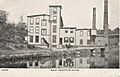
Summit Thread Company, 1906
-
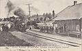
Railroad station, circa 1907
-
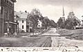
Main Street, circa 1907


See also
 In Spanish: East Hampton (Connecticut) para niños
