
Lake Pocotopaug, Connecticut facts for kids
Quick facts for kids
Lake Pocotopaug, Connecticut
|
|
|---|---|

Lake Pocotopaug
|
|

Lake Pocotopaug, Connecticut
Location in Connecticut

Lake Pocotopaug, Connecticut
Location in the United States
|
|
| Country | |
| State | Connecticut |
| County | Middlesex |
| Town | East Hampton |
| Area | |
| • Total | 16.30 km2 (6.293 sq mi) |
| • Land | 14.22 km2 (5.491 sq mi) |
| • Water | 2.08 km2 (0.802 sq mi) |
| Elevation | 140 m (470 ft) |
| Population
(2020)
|
|
| • Total | 4,901 |
| • Density | 344.6/km2 (892.6/sq mi) |
| Time zone | UTC-5 (Eastern (EST)) |
| • Summer (DST) | UTC-4 (EDT) |
| ZIP Code |
06424 (East Hampton)
|
| Area codes | 860/959 |
| FIPS code | 09-41410 |
| GNIS feature ID | 2377828 |
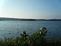
Lake Pocotopaug is a small community in East Hampton, Connecticut. It is known for its beautiful lake. In 2020, about 4,901 people lived here. This was more than the 3,436 people who lived here in 2010.
The area is named after the large lake, which has been a popular vacation spot for many years. Many homes are built around the lake. Most are lived in all year, but some are summer cottages. The lake is special because it has two islands in the middle. These islands are separated by a narrow, shallow area.
Contents
Discovering Lake Pocotopaug
Lake Pocotopaug is 512 acres (207 ha) big. While it is a large lake, other lakes in Connecticut are even bigger. For example, Candlewood Lake is much larger at 5,064 acres (2,049 ha).
The Lake's Name and Legends
The name "Pocotopaug" likely comes from the Wangunk Native American language. It might mean "Lake with Pierced Islands" or "Divided Pond." A local legend says that long ago, the tribe living there felt a Great Spirit was angry with them. To make the spirit happy, the chief's daughter bravely went into the lake and drowned. After this, the tribe's spiritual leaders said that no Native American would ever be harmed on the lake again.
The Wangunk people also hunted on a place called Spellman's Point. They would make loud noises to scare animals to the end of the peninsula. This was an effective way to gather food. Later, in the 1800s, this land was sold.
Fun at Sears Park
Sears Park is located right on the lake. It offers many activities for people who live nearby. You can go swimming, boating, and enjoy other fun outdoor activities there.
Protecting the Lake's Health
Since 2000, the lake has had problems with large amounts of algae growing. This is called an "algae bloom." Scientists have studied the lake and found that more buildings and the use of fertilizers on land around the lake are causing these issues.
Two groups are working to help the lake:
- The Lake Commission, which is supported by the town.
- The Friends of Lake Pocotopaug, a community organization.
Both groups are focused on finding ways to improve the lake's health.
Lake Restoration Efforts
In 2020, a big project started to help the lake. They began pumping fresh air into the bottom of the lake at different spots. This helps the water stay healthy. Also, a special "bioblast" treatment was done in August 2020. This treatment used helpful bacteria.
Because of these efforts, the water became much clearer in just one season. The water quality has continued to get better. This project has stopped the regular summer algae blooms that happened for almost 20 years. No major bloom happened in 2020. It's still being watched to see how long these improvements will last.
The lake has some hidden rocks that can be dangerous for boats. One of these rocks is marked by a small lighthouse in the southeast part of the lake. It is called "Claudia's Light - 2006." The light on it does not work right now, but kind people have helped to fix and repaint the lighthouse.
Where is Lake Pocotopaug?
Lake Pocotopaug is in the northeastern part of Middlesex County, Connecticut. It is located in the northern area of the town of East Hampton. The Lake Pocotopaug community includes the lake itself and the higher land around it.
It is next to the village of East Hampton to the south. To the west, it borders Meshomasic State Forest.
Size and Water Flow
The Lake Pocotopaug community covers about 6.3 square miles (16 km2). Of this, 5.5 square miles (14 km2) is land, and 0.8 square miles (2.1 km2) (about 12.74%) is water. The lake's water flows south into the village of East Hampton. From there, it continues through Pocotopaug Creek and Pine Brook. These streams eventually flow into the Salmon River, which then joins the Connecticut River.
People of Lake Pocotopaug
In 2000, there were 3,169 people living in the Lake Pocotopaug community. There were 1,347 households, and 844 of these were families. The population density was about 456.6 people per square kilometer (1,183.9 per square mile).
Most people living here were White (96.81%). There were also smaller groups of African American, Native American, and Asian residents. About 1.01% of the population was Hispanic or Latino.
The average household had 2.35 people, and the average family had 2.92 people. About 23.4% of the people were under 18 years old. The average age of residents was 38 years.
Images for kids
-
Lake Pocotopaug
See also
 In Spanish: Lake Pocotopaug para niños
