Lower Connecticut River Valley facts for kids
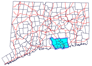
The Lower Connecticut River Valley is a special area in Connecticut. It's where the mighty Connecticut River meets the big Long Island Sound. This region includes towns in Middlesex County and the western part of New London County. You can find it in the southeastern-central part of the state.
Seventeen towns are part of this beautiful valley: Chester, Clinton, Cromwell, Deep River, Durham, East Haddam, East Hampton, Essex, Haddam, Killingworth, Lyme, Middlefield, Middletown, Old Lyme, Old Saybrook, Portland, and Westbrook.
Contents
Exploring the River Roads
Route 154 is a scenic road that follows the river. It starts in Middletown and goes all the way to Old Saybrook. This road is very popular with people who love to ride motorcycles because of its beautiful views.
Another important road is State Route 9. It runs through Cromwell and Middletown. This route then stretches to the shoreline, connecting with Interstate 95 in Old Saybrook.
Fun Things to Do in the Valley
The Lower Connecticut River Valley is famous for its lovely riverside views and charming towns. It has many fun places to visit for tourists and families.
Exciting Attractions
Some of the top attractions include:
- The Goodspeed Opera House: A historic theater known for amazing musicals.
- The Essex Steam Train: You can ride an old-fashioned steam train and boat.
- Brownstone Exploration and Discovery Park: A place for outdoor adventures.
- Powder Ridge Mountain Park and Resort: Great for skiing in winter and other activities in summer.
- The Traveler's Professional Golf Championship at TPC at River Highlands: A big golf tournament.
- Lyman Orchards: A farm where you can pick your own fruit and enjoy delicious treats.
- Lyman Orchards Golf Courses: Two great places to play golf.
- Fox Hopyard Golf Course: Another popular golf course.
- Gillette Castle: A unique and interesting castle that looks like it's from a fairy tale.
Middletown: A Hub of Activity
Middletown is the largest town in the region. It is one of Connecticut's smaller cities. It is also home to Wesleyan University, a well-known college.
A Look Back in Time
People have lived in the Lower Connecticut River Valley for a very long time. The oldest things found by archaeologists in this area date back to about 8000 BC. This means people were here over 10,000 years ago!
 | Percy Lavon Julian |
 | Katherine Johnson |
 | George Washington Carver |
 | Annie Easley |


