Eastham, Massachusetts facts for kids
Quick facts for kids
Eastham, Massachusetts
|
|||
|---|---|---|---|
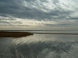
First Encounter Beach along Cape Cod Bay in Eastham
|
|||
|
|||
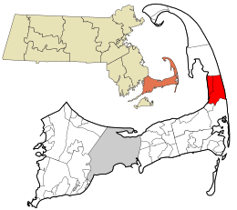
Location in Barnstable County and the state of Massachusetts.
|
|||
| Country | United States | ||
| State | Massachusetts | ||
| County | Barnstable | ||
| Settled | 1644 | ||
| Incorporated | 1651 | ||
| Communities |
|
||
| Government | |||
| • Type | Open town meeting | ||
| Area | |||
| • Total | 25.7 sq mi (66.6 km2) | ||
| • Land | 14.0 sq mi (36.2 km2) | ||
| • Water | 11.7 sq mi (30.4 km2) | ||
| Elevation | 48 ft (15 m) | ||
| Population
(2020)
|
|||
| • Total | 5,752 | ||
| • Density | 410/sq mi (159/km2) | ||
| Time zone | UTC−5 (Eastern) | ||
| • Summer (DST) | UTC−4 (Eastern) | ||
| ZIP Code |
02642
|
||
| Area code(s) | 508/774 | ||
| FIPS code | 25-19295 | ||
| GNIS feature ID | 0619414 | ||
Eastham (pronounced EES-tham) is a town in Barnstable County, Massachusetts, United States. It's located on Cape Cod, a famous arm-shaped peninsula. In 2020, about 5,752 people lived here. Eastham is known for its beautiful beaches and historical sites.
If you want to learn more about the village of North Eastham, you can check out its own article: North Eastham, Massachusetts.
Contents
History of Eastham
Eastham was first home to the Nauset tribe. In 1620, a group of Pilgrims from the ship Mayflower landed here. This was their first meeting with the Nauset people. This spot is now called First Encounter Beach.
Europeans didn't settle here until 1644. The area was much larger back then. It included what are now the towns of Truro, Wellfleet, Eastham, Orleans, and part of Chatham. Eastham officially became a town in 1651.
Eastham is the birthplace of Freeman Hatch. In 1853, he set a world record. He sailed a wooden ship, the Northern Light, from San Francisco around Cape Horn to Boston. Early jobs in Eastham included fishing and farming. Many writers and artists also came to live here. For example, Henry Beston wrote his famous book The Outermost House in Eastham.
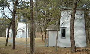
Today, Eastham is called the "Gateway” to the Cape Cod National Seashore. This special area was created in 1961 by President John F. Kennedy. Its goal is to protect Cape Cod's beautiful coast. The town has many beaches on both the Atlantic Ocean and Cape Cod Bay. You can also find the Nauset Light here. This lighthouse was moved to Eastham in 1923. There are also the Three Sisters Lighthouses, which were moved inland for safety.
Geography and Nature
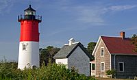
Eastham is located on the "forearm" of Cape Cod. It has Cape Cod Bay to its west and the Atlantic Ocean to its east. The towns of Wellfleet are to the north and Orleans to the south. Eastham is about 23 miles (37 km) south of Provincetown. It is also about 92 miles (148 km) southeast of Boston.
About one-third of Eastham is part of the Cape Cod National Seashore. This means a large part of the town's nature is protected. There are several freshwater ponds in the town. The biggest is Great Pond, which has two public beaches. You can use powerboats with small motors on Great Pond. Water skiing is allowed there on certain days. Smaller motorboats are allowed on other ponds.
Weather in Eastham
Eastham has a mild summer Humid continental climate. This means it has warm summers and cold, snowy winters. The average yearly snowfall is about 30 inches (76 cm). February is usually the snowiest month.
| Climate data for Eastham, Barnstable County, Massachusetts (1981–2010 averages). | |||||||||||||
|---|---|---|---|---|---|---|---|---|---|---|---|---|---|
| Month | Jan | Feb | Mar | Apr | May | Jun | Jul | Aug | Sep | Oct | Nov | Dec | Year |
| Mean daily maximum °F (°C) | 38.0 (3.3) |
39.4 (4.1) |
44.5 (6.9) |
53.2 (11.8) |
62.5 (16.9) |
71.1 (21.7) |
77.4 (25.2) |
76.9 (24.9) |
70.4 (21.3) |
60.5 (15.8) |
52.5 (11.4) |
44.0 (6.7) |
57.6 (14.2) |
| Daily mean °F (°C) | 31.5 (−0.3) |
32.7 (0.4) |
37.7 (3.2) |
46.2 (7.9) |
55.1 (12.8) |
64.0 (17.8) |
70.5 (21.4) |
70.1 (21.2) |
63.9 (17.7) |
54.2 (12.3) |
46.1 (7.8) |
37.3 (2.9) |
50.9 (10.5) |
| Mean daily minimum °F (°C) | 25.1 (−3.8) |
25.9 (−3.4) |
30.8 (−0.7) |
39.1 (3.9) |
47.7 (8.7) |
57.0 (13.9) |
63.6 (17.6) |
63.4 (17.4) |
57.3 (14.1) |
47.8 (8.8) |
39.8 (4.3) |
30.6 (−0.8) |
44.1 (6.7) |
| Average precipitation inches (mm) | 3.73 (95) |
3.24 (82) |
4.14 (105) |
4.29 (109) |
3.32 (84) |
3.56 (90) |
2.74 (70) |
3.87 (98) |
3.60 (91) |
4.19 (106) |
4.30 (109) |
3.84 (98) |
44.82 (1,138) |
| Average relative humidity (%) | 71.4 | 69.4 | 67.8 | 69.0 | 71.6 | 75.5 | 78.0 | 77.9 | 77.4 | 74.3 | 71.2 | 69.7 | 72.8 |
| Source: PRISM Climate Group | |||||||||||||
Getting Around Eastham
U.S. Route 6 runs through Eastham from south to north. This is a main road for driving. The Cape Cod Rail Trail is also here. It's a popular path for biking and walking.
Eastham does not have its own train station or airport. The closest small airport is in Chatham. For bigger flights, you can go to Logan International Airport in Boston. Eastham also has a local bus service called The Flex.
People of Eastham
| Historical population | ||
|---|---|---|
| Year | Pop. | ±% |
| 1850 | 845 | — |
| 1860 | 779 | −7.8% |
| 1870 | 668 | −14.2% |
| 1880 | 692 | +3.6% |
| 1890 | 602 | −13.0% |
| 1900 | 502 | −16.6% |
| 1910 | 518 | +3.2% |
| 1920 | 430 | −17.0% |
| 1930 | 543 | +26.3% |
| 1940 | 582 | +7.2% |
| 1950 | 860 | +47.8% |
| 1960 | 1,200 | +39.5% |
| 1970 | 2,043 | +70.2% |
| 1980 | 3,472 | +69.9% |
| 1990 | 4,462 | +28.5% |
| 2000 | 5,453 | +22.2% |
| 2010 | 4,956 | −9.1% |
| 2020 | 5,752 | +16.1% |
| 2023* | 5,803 | +0.9% |
| * = population estimate. Source: United States Census records and Population Estimates Program data. |
||
According to the 2010 census, there were 4,956 people living in Eastham. The population has grown over the years. The average age of people in Eastham was 48 years old.
Schools in Eastham
Eastham is part of the Nauset Regional School District. This district also includes Brewster, Orleans, Provincetown, Truro, and Wellfleet. Each town has its own elementary schools. Middle and high school students go to regional schools.
- Eastham Elementary School teaches students from kindergarten to fifth grade.
- Middle school students attend Nauset Regional Middle School in Orleans.
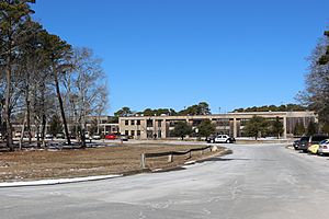
- High school students go to Nauset Regional High School in North Eastham. The school's sports teams are called the Warriors, and their colors are black and gold.
- Students can also choose to attend Cape Cod Regional Technical High School in Harwich. This school teaches job skills.
There are no private schools in Eastham itself.
Famous Places and Landmarks
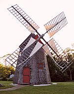
Eastham has many places that are important to history. These are listed on the National Register of Historic Places.
- The Eastham Center Historic District is near Town Hall. Here you can see the Eastham Windmill, which is the oldest windmill on Cape Cod.
- Nauset Light is another famous landmark. It's a lighthouse located within the Cape Cod National Seashore.
- The Edward Penniman House and barn belonged to a retired whaling captain.
The Eastham Historical Society takes care of four museums:
- The 1869 Schoolhouse Museum
- The 1741 Swift-Daley House
- The Antique Tool Museum
- The Dill Beach Shack
These museums are usually open in July and August.
See also
 In Spanish: Eastham (Massachusetts) para niños
 | Precious Adams |
 | Lauren Anderson |
 | Janet Collins |


