
Chatham, Massachusetts facts for kids
Quick facts for kids
Chatham, Massachusetts
|
|||
|---|---|---|---|
|
|||

Location in Barnstable County, Massachusetts
|
|||
| Country | United States | ||
| State | Massachusetts | ||
| County | Barnstable | ||
| Settled | 1664 | ||
| Incorporated | 1712 | ||
| Named After | Chatham, Kent | ||
| Communities |
|
||
| Government | |||
| • Type | Open town meeting | ||
| Area | |||
| • Total | 24.4 sq mi (63.2 km2) | ||
| • Land | 16.1 sq mi (41.8 km2) | ||
| • Water | 8.3 sq mi (21.4 km2) | ||
| Elevation | 46 ft (14 m) | ||
| Population
(2020)
|
|||
| • Total | 6,594 | ||
| • Density | 409/sq mi (157.8/km2) | ||
| Time zone | UTC−5 (Eastern) | ||
| • Summer (DST) | UTC−4 (Eastern) | ||
| ZIP Code |
02633
|
||
| Area code(s) | 508/774 | ||
| FIPS code | 25-12995 | ||
| GNIS feature ID | 0618250 | ||


Chatham is a town in Barnstable County, Massachusetts, USA. It's located at the very tip of Cape Cod. For a long time, it was a busy fishing town.
English settlers first arrived in 1664. They called the area Monomoit, using a name from the local Native American people. Chatham officially became a town on June 11, 1712. Today, it's a very popular place for summer vacations.
In 2020, about 6,594 people lived there. But in the summer, the population can grow to 25,000! Chatham has four main villages: Chatham (CDP), South Chatham, North Chatham, and West Chatham.
You can find the Monomoy National Wildlife Refuge and the old Monomoy Point Light on Monomoy Island in Chatham. A famous landmark is the Chatham Light, a working lighthouse run by the United States Coast Guard.
Contents
Chatham's History
Native American tribes, like the Nauset people, lived here before Europeans arrived. They called their land Manamoyik or Monomoit. In 1606, explorer Samuel de Champlain landed here. He named the spot "Port Fortuné."
English settlers permanently moved to Monomoit in 1664. The town was officially formed on June 11, 1712. It was renamed after Chatham, Kent, in England. Later, in 1797, Strong Island and nearby areas joined Chatham.
How Chatham Grew
Chatham is at the "elbow" of Cape Cod. It became a busy center for shipping, fishing, and whaling. Because of its early success, Chatham has many charming buildings from the 1700s. These old buildings helped the town become a popular summer resort.
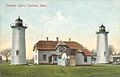
The Chatham Lighthouse
The Chatham Lighthouse was built in 1808 by President Thomas Jefferson. It helped guide ships around the Cape. The original towers were replaced in 1841 with brick ones, but these were lost to erosion.
In 1877, new cast-iron towers were built across the street from the first location. In 1923, one of these towers was moved to Eastham and became the Nauset Light. Today, the lighthouse keeper's house is a Coast Guard station. They patrol the waters from Wellfleet to West Yarmouth.
In 1821, the first tree-planting project in America happened in Chatham. Pine trees and beach grass were planted on Great Hill to stop erosion and keep sand from blowing into the village.
Life in Chatham Today
Even though many areas on Cape Cod have grown a lot, Chatham still has a charming and walkable Main Street. You'll find many family-owned shops, restaurants, and businesses there. The main shopping area has easy-to-use crosswalks and parking.
In the summer, concerts are held in a gazebo on Main Street. Not far from the shops, the Chatham Anglers baseball team plays. They are part of the Cape Cod Baseball League for college-age players.
Many young people and families are leaving Chatham. This is because housing is very expensive, and there aren't many job opportunities. Most homes in Chatham are empty in the winter. They are used as summer homes or rented to tourists. In 2012, the average price for a home in Chatham was $1.3 million.
In summer, Chatham's population can reach 30,000 people. This means facilities can get crowded, and parking is limited. Even popular beaches like Lighthouse Beach can be a long walk from parking.
Historical Sites and Museums
Chatham has several interesting historical places to visit:
- Atwood House (built in 1752)
- Caleb Nickerson House (built in 1772)
- Chatham Railroad Museum (built in 1887)
- Josiah Mayo House (around 1820)
- Old Grist Mill (built in 1797)
Chatham's Geography


Chatham is located at the southeast corner, or "elbow," of Cape Cod. Its villages include Chatham proper, Chatham Port, North Chatham, West Chatham, and South Chatham.
Chatham shares borders with Harwich to the west and Orleans to the north. The Atlantic Ocean is to the east, and Nantucket Sound is to the south. The town is about 35 miles (56 km) south of Provincetown. It is also 20 miles (32 km) east of Barnstable and 85 miles (137 km) southeast of Boston.
The town covers a total area of 24.4 square miles (63.2 sq km). About 16.1 square miles (41.8 sq km) is land, and 8.3 square miles (21.4 sq km) is water.
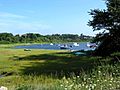
Chatham's mainland has many ponds, brooks, rivers, harbors, and inlets. The town also includes two narrow strips of land that protect the mainland from the Atlantic Ocean. The northern strip is part of the Cape Cod National Seashore.
There are several islands, such as Strong Island, Tern Island (a bird sanctuary), Morris Island, Stage Island, and Monomoy Island. Monomoy Island is about 7.25 miles (11.67 km) long. It is home to the Monomoy National Wildlife Refuge. The shape of the land here has changed over many years due to erosion.
Chatham's Climate
Chatham has an Oceanic climate, which means it has mild winters and warm summers. It is in Hardiness zone 7b.
| Climate data for Cape Cod (Chatham, Massachusetts) | |||||||||||||
|---|---|---|---|---|---|---|---|---|---|---|---|---|---|
| Month | Jan | Feb | Mar | Apr | May | Jun | Jul | Aug | Sep | Oct | Nov | Dec | Year |
| Record high °F (°C) | 61 (16) |
57 (14) |
77 (25) |
81 (27) |
88 (31) |
90 (32) |
95 (35) |
93 (34) |
85 (29) |
82 (28) |
68 (20) |
69 (21) |
95 (35) |
| Mean daily maximum °F (°C) | 37.6 (3.1) |
38.3 (3.5) |
42.8 (6.0) |
50.5 (10.3) |
59.0 (15.0) |
68.4 (20.2) |
74.9 (23.8) |
74.7 (23.7) |
69.4 (20.8) |
60.0 (15.6) |
51.7 (10.9) |
42.8 (6.0) |
55.9 (13.3) |
| Daily mean °F (°C) | 30.9 (−0.6) |
31.7 (−0.2) |
36.7 (2.6) |
45.1 (7.3) |
53.6 (12.0) |
62.6 (17.0) |
68.8 (20.4) |
68.7 (20.4) |
63.6 (17.6) |
53.9 (12.2) |
45.6 (7.6) |
36.5 (2.5) |
49.9 (9.9) |
| Mean daily minimum °F (°C) | 24.1 (−4.4) |
25.0 (−3.9) |
30.7 (−0.7) |
39.6 (4.2) |
48.1 (8.9) |
56.7 (13.7) |
62.7 (17.1) |
62.6 (17.0) |
57.7 (14.3) |
47.8 (8.8) |
39.6 (4.2) |
30.2 (−1.0) |
43.8 (6.6) |
| Record low °F (°C) | −6 (−21) |
−4 (−20) |
7 (−14) |
19 (−7) |
33 (1) |
44 (7) |
51 (11) |
47 (8) |
40 (4) |
31 (−1) |
19 (−7) |
0 (−18) |
−6 (−21) |
| Average precipitation inches (mm) | 3.83 (97) |
4.24 (108) |
4.85 (123) |
4.14 (105) |
3.81 (97) |
3.41 (87) |
3.28 (83) |
3.20 (81) |
3.83 (97) |
4.04 (103) |
4.03 (102) |
4.38 (111) |
47.04 (1,195) |
| Average snowfall inches (cm) | 8.2 (21) |
10.3 (26) |
3.5 (8.9) |
0.6 (1.5) |
0 (0) |
0 (0) |
0 (0) |
0 (0) |
0 (0) |
0 (0) |
0.4 (1.0) |
3.6 (9.1) |
26.6 (68) |
| Average precipitation days (≥ 0.01 in) | 12 | 10 | 12 | 11 | 11 | 9 | 8 | 8 | 9 | 10 | 11 | 13 | 125 |
| Source 1: Western Regional Climate Center (normals 1981–2010, extremes and snow 1972–present) | |||||||||||||
| Source 2: NOAA | |||||||||||||
Chatham's Wildlife and Nature
The area around Chatham has many different plants and animals. Many species rely on the wetlands, like salt marshes and lakes, to survive. These wetlands were formed by glaciers from the last ice age.
They are important homes for animals like ospreys and striped bass. These wetlands also help clean the water that flows into nearby bays.
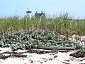
Chatham's beaches have lost a lot of plants recently due to natural causes and human activity. However, the beaches are still important nesting spots for sea turtles and shorebirds, like the Piping Plover.
The waters off the coast are full of marine life. You can find seals, whales, and even great white sharks here. Chatham is known for having many great white sharks, which has led to shark attacks. To protect nature, Chatham has several conservation areas, including Monomoy Island. This island is a key breeding ground for the Piping Plover.
The natural plants in Chatham would mostly be Northeastern Oak and Pine trees.
Getting Around Chatham
All five roads that leave Chatham go into Harwich. The two main state roads are Route 28 and the southern end of Route 137. Route 28 goes through the center of town.
There is no longer train service to Chatham. The old train tracks are now a bike path called the Old Colony Rail Trail. This trail goes through South Chatham and West Chatham. Another bike path starts where the Rail Trail ends. It offers great views of Chatham Fish Pier, Chatham Bars, and Chatham Light.
Chatham also has the Chatham Municipal Airport. This airport offers flights to other small airports on Cape Cod and the islands. For bigger flights, the closest major airport is Logan International Airport in Boston.
Chatham's Population and People
| Historical population | ||
|---|---|---|
| Year | Pop. | ±% |
| 1850 | 2,439 | — |
| 1860 | 2,710 | +11.1% |
| 1870 | 2,411 | −11.0% |
| 1880 | 2,250 | −6.7% |
| 1890 | 1,954 | −13.2% |
| 1900 | 1,749 | −10.5% |
| 1910 | 1,564 | −10.6% |
| 1920 | 1,737 | +11.1% |
| 1930 | 1,931 | +11.2% |
| 1940 | 2,136 | +10.6% |
| 1950 | 2,457 | +15.0% |
| 1960 | 3,273 | +33.2% |
| 1970 | 4,554 | +39.1% |
| 1980 | 6,071 | +33.3% |
| 1990 | 6,579 | +8.4% |
| 2000 | 6,625 | +0.7% |
| 2010 | 6,125 | −7.5% |
| 2020 | 6,594 | +7.7% |
| 2023* | 6,685 | +1.4% |
| * = population estimate. | ||

In 2000, there were 6,625 people living in Chatham. Most people (96%) were White. About 1% of the population was Hispanic or Latino.
During the summer, Chatham's population can triple to about 20,000 people. This doesn't even count all the tourists staying in hotels and inns. Tourism and hospitality, along with commercial fishing, are the main jobs in Chatham. The town has a busy fish pier where boats unload fresh fish and lobster every day.
In 2000, about 15.3% of households had children under 18. The average age of people in Chatham was 54 years old. Many residents were 65 or older (34.3%).
The local school system for students from kindergarten to 12th grade has about 700 students. High school classes usually have between 30 and 40 students.
Education in Chatham
Until 2013, Chatham had its own schools. Students went to Chatham Elementary School (Pre-K to 4th grade), Chatham Middle School (5th to 8th grade), and Chatham High School (9th to 12th grade). Their sports teams were called the Blue Devils.
In 2010, Chatham and the nearby town of Harwich decided to combine their school systems. This created the Monomoy Regional school system. Their new sports teams are called the Sharks. In 2013, construction began on a new high school in Harwich for the region.
Students can also attend Cape Cod Regional Technical High School in Harwich for free. There are also private schools in nearby Brewster and Harwich.
Sports and Fun in Chatham
.jpg)
Chatham is home to the Chatham Anglers. This is an amateur collegiate summer baseball team in the Cape Cod Baseball League. The team plays at Veteran's Field. Many players from the Anglers have gone on to play in Major League Baseball, like Thurman Munson, Jeff Bagwell, and Kris Bryant.
Eastward Ho! Golf Course is a well-known golf course in town. It even hosted a PGA Tour event called The Cape Cod Open in the 1930s.
Famous People from Chatham
- Zered Bassett, pro skateboarder, grew up in Chatham
- Shirley Booth, actress
- Ruby Braff, musician, died in Chatham
- Louis Brandeis, Supreme Court Justice
- Bernard Cornwell, best-selling author
- Franklin Cover, late actor
- Todd Eldredge, champion figure skater
- Jack Forrester, Scottish-American professional golfer
- Lisa Genova, best-selling author
- Bobby Hackett, musician
- Julie Harris, actress
- Gilbert Knapp, Wisconsin State Assemblyman
- Joseph C. Lincoln, author of Cape Cod Stories
- Joseph Lord, Puritan pastor
- Sara Pennypacker, children's book author
- Bill Richardson, American politician, author, and diplomat
- Christopher Seufert, film director/photographer
- Maxim D. Shrayer, bilingual author
- Archelaus Smith, Nova Scotia pioneer
- Bob Staake, cartoonist & illustrator
- Tisquantum (Squanto), died in Chatham and is buried in an unmarked grave on Burial Hill, overlooking Ryder's Cove
- Stuart Varney, talk show host
- Bernard C. Webber, heroic Coast Guardsman who was award the Gold Lifesaving Medal for leading a rescue to the SS Pendleton in 1952
Images for kids
-
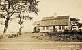
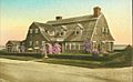
The Atwood House
-
Chatham Lights
-
Stage Harbor Light
-
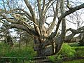
Old Linden Tree (April 2012)
-
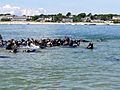
Seals in Chatham Harbor
-
Cross Trees
-
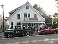
Chatham Cookware (Summer 2024)
-
-


See also
 In Spanish: Chatham (Massachusetts) para niños
