
Orleans, Massachusetts facts for kids
Quick facts for kids
Orleans, Massachusetts
|
|||
|---|---|---|---|

Orleans Town Hall
|
|||
|
|||

Location in Barnstable County and the state of Massachusetts.
|
|||
| Country | United States | ||
| State | Massachusetts | ||
| County | Barnstable | ||
| Settled | 1693 | ||
| Incorporated | 1797 | ||
| Government | |||
| • Type | Open town meeting | ||
| Area | |||
| • Total | 22.7 sq mi (58.7 km2) | ||
| • Land | 14.1 sq mi (36.6 km2) | ||
| • Water | 8.5 sq mi (22.0 km2) | ||
| Elevation | 60 ft (18 m) | ||
| Population
(2020)
|
|||
| • Total | 6,307 | ||
| • Density | 446/sq mi (172.3/km2) | ||
| Time zone | UTC−5 (Eastern) | ||
| • Summer (DST) | UTC−4 (Eastern) | ||
| ZIP Code |
02653
|
||
| Area code(s) | 508 | ||
| FIPS code | 25-51440 | ||
| GNIS feature ID | 0618257 | ||


Orleans is a town in Barnstable County, Massachusetts, United States. It is located along Cape Cod, a famous arm-shaped peninsula. In 2020, the town had a population of 6,307 people.
For more details about the specific area called Orleans (CDP), you can check the article Orleans CDP.
Contents
History of Orleans
Orleans was first settled in 1693 by Pilgrims from the Plymouth Colony. They were looking for better land to farm. The town officially separated from Eastham and became its own town in 1797. It was named after Louis Philippe II, Duke of Orléans from France. This was to thank France for helping the Thirteen Colonies during the American Revolution. The town also wanted a name that wasn't English, as British forces had captured it twice during the war.
In its early days, Orleans was important for fishing, whaling, and farming. As fishing grew, salt works were built to help preserve the fish. However, the town used up most of its trees for lumber. This problem was solved in the 1800s when the railroad arrived, bringing lumber from other places. The railroad also helped bring tourists to the town. In 1898, the French Cable Company built a very long transatlantic telegraph cable (about 3,200 miles or 5,100 km) to Orleans. This cable operated from the French Cable Station.
During World War I, in July 1918, a German submarine attacked Orleans by shelling it. This event is known as the Attack on Orleans. The town's tourism industry got a big boost in 1961. That's when President John F. Kennedy created the Cape Cod National Seashore, protecting many beautiful coastal areas.
Geography of Orleans
Orleans covers a total area of about 58.7 square kilometers (22.7 sq mi). About 36.6 square kilometers (14.1 sq mi) of this is land, and 22.0 square kilometers (8.5 sq mi) is water. Orleans is located on the inner "elbow" part of Cape Cod.
The town is surrounded by other towns and water bodies. To the north is Eastham. The Atlantic Ocean is to the east. To the south, you'll find Pleasant Bay and the town of Chatham. Harwich is to the southwest, and Brewster is to the west. Cape Cod Bay is to the northwest.
Orleans is about 27 miles (43 km) south of Provincetown. It's also about 22 miles (35 km) east of Barnstable. The town has many bogs and ponds in its western part. Along the eastern coast, there are many inlets, islands, and harbors. These include Town Cove, Nauset Harbor, Pleasant Bay, and Little Pleasant Bay. Rock Harbor, which Orleans shares with Eastham, offers access to Cape Cod Bay for boats. A large part of the Cape Cod National Seashore is also along the coast here.
Transportation in Orleans
The town line between Eastham and Orleans is where two main Massachusetts routes, Route 6A and Route 28, begin or end. These two routes meet in the center of Orleans. They then end at a traffic circle with Route 6 at the Eastham town line. Massachusetts Route 39 also ends in the southern part of Orleans at Route 28.
Orleans does not have its own train station or airport. You can find regional air service in nearby Hyannis. The closest major airport for national and international flights is Logan International Airport in Boston. The Cape Cod Regional Transit Authority operates buses that travel across Cape Cod. One of these bus lines has several stops in Orleans, connecting it to Hyannis.
Climate in Orleans
Orleans has a mild summer Humid continental climate. This means it has warm, humid summers and cold winters. The average annual extreme minimum temperature is about 4.0 °F (−15.6 °C). The town typically gets around 30 inches (76 cm) of snow each year, mostly between November and April. February is usually the snowiest month.
| Climate data for Orleans, Barnstable County, Massachusetts (1981–2010 averages). | |||||||||||||
|---|---|---|---|---|---|---|---|---|---|---|---|---|---|
| Month | Jan | Feb | Mar | Apr | May | Jun | Jul | Aug | Sep | Oct | Nov | Dec | Year |
| Mean daily maximum °F (°C) | 37.9 (3.3) |
39.1 (3.9) |
44.1 (6.7) |
52.1 (11.2) |
61.3 (16.3) |
70.0 (21.1) |
76.6 (24.8) |
76.3 (24.6) |
70.1 (21.2) |
60.3 (15.7) |
52.3 (11.3) |
43.7 (6.5) |
57.1 (13.9) |
| Daily mean °F (°C) | 31.3 (−0.4) |
32.5 (0.3) |
37.5 (3.1) |
45.6 (7.6) |
54.4 (12.4) |
63.5 (17.5) |
70.0 (21.1) |
69.8 (21.0) |
63.7 (17.6) |
53.9 (12.2) |
46.0 (7.8) |
37.0 (2.8) |
50.5 (10.3) |
| Mean daily minimum °F (°C) | 24.8 (−4.0) |
25.9 (−3.4) |
30.8 (−0.7) |
39.0 (3.9) |
47.6 (8.7) |
57.0 (13.9) |
63.5 (17.5) |
63.3 (17.4) |
57.2 (14.0) |
47.5 (8.6) |
39.7 (4.3) |
30.4 (−0.9) |
44.0 (6.7) |
| Average precipitation inches (mm) | 3.78 (96) |
3.52 (89) |
4.46 (113) |
4.36 (111) |
3.48 (88) |
3.58 (91) |
2.95 (75) |
3.64 (92) |
3.65 (93) |
3.89 (99) |
4.10 (104) |
3.95 (100) |
45.36 (1,152) |
| Average relative humidity (%) | 72.2 | 70.9 | 68.6 | 70.9 | 73.5 | 77.4 | 79.9 | 79.6 | 78.5 | 76.0 | 72.3 | 71.1 | 74.3 |
| Source: PRISM Climate Group | |||||||||||||
| Month | Jan | Feb | Mar | Apr | May | Jun | Jul | Aug | Sep | Oct | Nov | Dec | Year |
|---|---|---|---|---|---|---|---|---|---|---|---|---|---|
| Average Dew Point °F | 23.4 | 24.1 | 28.1 | 36.7 | 46.1 | 56.3 | 63.5 | 63.2 | 56.9 | 46.5 | 37.6 | 28.5 | 42.7 |
| Average Dew Point °C | −4.8 | −4.4 | −2.2 | 2.6 | 7.8 | 13.5 | 17.5 | 17.3 | 13.8 | 8.1 | 3.1 | −1.9 | 5.9 |
|
Source: PRISM Climate Group
|
|||||||||||||
Population of Orleans
| Historical population | ||
|---|---|---|
| Year | Pop. | ±% |
| 1850 | 1,848 | — |
| 1860 | 1,678 | −9.2% |
| 1870 | 1,323 | −21.2% |
| 1880 | 1,294 | −2.2% |
| 1890 | 1,219 | −5.8% |
| 1900 | 1,123 | −7.9% |
| 1910 | 1,077 | −4.1% |
| 1920 | 1,012 | −6.0% |
| 1930 | 1,181 | +16.7% |
| 1940 | 1,451 | +22.9% |
| 1950 | 1,759 | +21.2% |
| 1960 | 2,342 | +33.1% |
| 1970 | 3,055 | +30.4% |
| 1980 | 5,306 | +73.7% |
| 1990 | 5,838 | +10.0% |
| 2000 | 6,341 | +8.6% |
| 2010 | 5,890 | −7.1% |
| 2020 | 6,307 | +7.1% |
| 2023* | 6,385 | +1.2% |
| *=population estimates only Source: United States Census records and Population Estimates Program data. |
||
In 2000, there were 6,341 people living in Orleans. The town had 3,087 households. About 14.8% of these households had children under 18. The average household size was 2.00 people.
The population was spread out in terms of age. About 13.8% of residents were under 18. A large portion, 36.0%, were 65 years or older. The median age in Orleans was 56 years.
Education in Orleans
Orleans is part of the Nauset Regional School District, which also includes Brewster, Eastham, and Wellfleet. Each town has its own elementary school. However, students from all these towns attend regional schools for middle and high school.
Orleans has the Orleans Elementary School for students from kindergarten to fifth grade. The town is also home to Nauset Regional Middle School. This school serves students from sixth through eighth grade from across the district. For high school, students go to Nauset Regional High School in North Eastham. They can also choose to attend Cape Cod Regional Technical High School in Harwich for free.
Sports and Recreation in Orleans
.jpg)
Orleans is home to the Orleans Firebirds, a summer baseball team for college players. They play at Eldredge Park. Many players from the Firebirds have gone on to play in Major League Baseball. Some famous players include Frank Thomas, Nomar Garciaparra, and Marcus Stroman.
Attacks in Wartime
Orleans is located on an open part of the coast, which has made it a target during wars. In 1814, during the War of 1812, the town's residents successfully fought off an attack by British marines. These marines were from the ship HMS Newcastle.
During World War I, in July 1918, Nauset Beach in Orleans was the only place in the United States hit by enemy shells. These shells were fired by a German submarine and seemed to be aimed at barges near the shore. This was the first time a foreign country had fired artillery on United States soil since 1848.
Images for kids
-
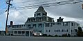
The Orleans Inn, located between Town Cove and Route 28.
-

The Jonathan Young Windmill, a restored 18th-century windmill near Town Cove.


See also
 In Spanish: Orleans (Massachusetts) para niños
