
Wellfleet, Massachusetts facts for kids
Quick facts for kids
Wellfleet, Massachusetts
|
||
|---|---|---|

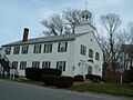
Wellfleet Town Hall
|
||
|
||

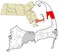
Location in Barnstable County and the state of Massachusetts.
|
||
| Country | United States | |
| State | Massachusetts | |
| County | Barnstable | |
| Incorporated | 1763 | |
| Government | ||
| • Type | Open town meeting | |
| Area | ||
| • Total | 35.4 sq mi (91.7 km2) | |
| • Land | 19.8 sq mi (51.3 km2) | |
| • Water | 15.6 sq mi (40.5 km2) | |
| Elevation | 50 ft (15 m) | |
| Population
(2020)
|
||
| • Total | 3,566 | |
| • Density | 180/sq mi (69.5/km2) | |
| Time zone | UTC−5 (Eastern) | |
| • Summer (DST) | UTC−4 (Eastern) | |
| ZIP Codes |
02663, 02667
|
|
| Area code(s) | 508/774 | |
| FIPS code | 25-74385 | |
| GNIS feature ID | 0618261 | |

Wellfleet is a town in Barnstable County, Massachusetts. It is located on Cape Cod, about halfway between the "tip" and the "elbow" of the Cape. In 2020, about 3,566 people lived there. However, this number grows much larger in the summer! A big part of Wellfleet's land, about 70%, is protected. Nearly half of it is part of the Cape Cod National Seashore. Wellfleet is very well known for its delicious oysters. People celebrate them every October at the annual Wellfleet OysterFest.
Contents
Wellfleet's Interesting History
The area where Wellfleet is now was first settled by Europeans in the 1650s. It was called Billingsgate back then. This name came from a famous fish market in London.
Pirates and Shipwrecks
In 1717, a famous pirate named "Black Sam" Bellamy was sailing near Wellfleet. His ship, the Whydah, sank offshore. It carried a huge treasure of gold and silver. Sadly, almost all of its 145 crew members were lost. In 1984, the shipwreck was found. It was one of the first pirate shipwrecks ever discovered.
From Village to Town
Wellfleet used to be part of a nearby town called Eastham. After asking for nearly 30 years, Wellfleet officially became its own town in 1763. The town's early economy was based on its oyster beds. Whaling (hunting whales) and fishing were also very important. During the American Revolution, Wellfleet had 30 whaling ships!
Changes in Fishing and Technology
By the late 1800s, whaling and mackerel fishing became less popular. So, Wellfleet's large fishing fleet got smaller. By 1900, there were no more large sailing ships called schooners. However, oyster fishing continued to thrive. Many types of shellfish are still harvested today. Even with these changes, a church in the town center still has a clock that chimes "ship's time." This is a special way sailors used to tell time.

In 1901, Guglielmo Marconi built the first transatlantic radio transmitter station in the USA. It was located on a cliff in South Wellfleet. On January 18, 1903, the first radio message from the United States to England was sent from this station. It was a special message from President Theodore Roosevelt to King Edward VII. Most of this station is now gone because the land has been washed away by the sea.
Protecting Nature: Cape Cod National Seashore
In 1961, President John F. Kennedy created the Cape Cod National Seashore. This special area protects most of the Atlantic coastline of Cape Cod. In Wellfleet, the Seashore goes around the town. It includes marshes, islands along the Herring River, and Cahoon Hollow Beach.
Wellfleet Today: Tourism and Art
In the late 1800s, the Chequessett Inn was built. This helped Wellfleet become a popular place for tourists. Today, Wellfleet has many art galleries. It has the second-highest number of galleries on Cape Cod, after Provincetown. It's also a popular place for people to retire.
Wellfleet's Geography and Nature
Wellfleet is a town with a total area of about 91.7 square kilometers (35.4 square miles). About 51.3 square kilometers (19.8 square miles) is land, and 40.5 square kilometers (15.6 square miles) is water. Wellfleet is surrounded by other towns and water bodies. To the north is Truro, to the east is the Atlantic Ocean, to the south is Eastham, and to the west is Cape Cod Bay.
Wellfleet Harbor and Islands
The town of Wellfleet wraps around Wellfleet Harbor. This harbor once had an island called Billingsgate Island. It was at the mouth of the harbor and even had a lighthouse. But over time, the ocean eroded the island. Now, it's just a sandbar that you can see at low tide.
Several small waterways flow inland from the harbor. These include the Herring River, Duck Creek, and Fresh Brook.
Protected Natural Areas
Besides the Cape Cod National Seashore, there's also the Wellfleet Bay Wildlife Sanctuary. This sanctuary is run by Massachusetts Audubon. It protects a lot of land, including parts of Small Island. Between the sanctuary, the seashore, and other parks, about 70% of Wellfleet's land is protected. This means it's kept safe for nature and wildlife.
A small whaling village once existed in what is now the Wellfleet Bay Wildlife Sanctuary. It was called Silver Spring. Today, all that remains is a marsh that used to be its harbor. This land is now protected by the Massachusetts Audubon Society.
Wellfleet's Climate
Wellfleet has a mild summer climate. This means summers are warm but not too hot, and winters are cold. The average snowfall from November to April is about 30 inches (76 cm). February is usually the snowiest month.
| Climate data for Wellfleet, Barnstable County, Massachusetts (1981–2010 averages). | |||||||||||||
|---|---|---|---|---|---|---|---|---|---|---|---|---|---|
| Month | Jan | Feb | Mar | Apr | May | Jun | Jul | Aug | Sep | Oct | Nov | Dec | Year |
| Mean daily maximum °F (°C) | 38.2 (3.4) |
39.5 (4.2) |
44.7 (7.1) |
53.5 (11.9) |
62.8 (17.1) |
72.0 (22.2) |
78.2 (25.7) |
77.4 (25.2) |
70.8 (21.6) |
61.0 (16.1) |
52.8 (11.6) |
44.1 (6.7) |
58.0 (14.4) |
| Daily mean °F (°C) | 31.6 (−0.2) |
32.8 (0.4) |
37.8 (3.2) |
46.3 (7.9) |
55.3 (12.9) |
64.5 (18.1) |
70.9 (21.6) |
70.4 (21.3) |
64.0 (17.8) |
54.4 (12.4) |
46.2 (7.9) |
37.3 (2.9) |
51.0 (10.6) |
| Mean daily minimum °F (°C) | 25.1 (−3.8) |
26.0 (−3.3) |
30.9 (−0.6) |
39.1 (3.9) |
47.8 (8.8) |
57.1 (13.9) |
63.6 (17.6) |
63.4 (17.4) |
57.3 (14.1) |
47.8 (8.8) |
39.6 (4.2) |
30.5 (−0.8) |
44.1 (6.7) |
| Average precipitation inches (cm) | — | 3.16 (8.0) |
4.05 (10.3) |
4.27 (10.8) |
3.28 (8.3) |
3.55 (9.0) |
2.68 (6.8) |
3.92 (10.0) |
3.59 (9.1) |
4.26 (10.8) |
4.35 (11.0) |
3.80 (9.7) |
44.63 (113.4) |
| Average relative humidity (%) | 70.2 | 68.3 | 67.2 | 68.5 | 70.8 | 74.2 | 76.4 | 76.3 | 76.6 | 72.6 | 69.6 | 68.5 | 71.6 |
| Source: PRISM Climate Group | |||||||||||||
| Month | Jan | Feb | Mar | Apr | May | Jun | Jul | Aug | Sep | Oct | Nov | Dec | Year |
|---|---|---|---|---|---|---|---|---|---|---|---|---|---|
| Average Dew Point °F | 23.0 | 23.5 | 27.9 | 36.5 | 46.0 | 56.1 | 63.1 | 62.6 | 56.5 | 45.8 | 36.8 | 27.9 | 42.2 |
| Average Dew Point °C | −5.0 | −4.7 | −2.3 | 2.5 | 7.8 | 13.4 | 17.3 | 17.0 | 13.6 | 7.7 | 2.7 | −2.3 | 5.7 |
|
Source = PRISM Climate Group
|
|||||||||||||
Getting Around Wellfleet
U.S. Route 6 is the main road that goes through Wellfleet from north to south. The town's main shopping area is west of this road, near the harbor.
Old Rail Lines and Bus Service
Wellfleet does not have train or air service. The last train left the area in the 1930s. The old train tracks were removed and turned into a bike path. This path is called the Cod Rail Trail, and it ends in South Wellfleet. The closest airports are in Chatham and Provincetown. For bigger flights, you would go to Logan International Airport in Boston.
There is some bus service in Wellfleet. You can take a bus to Hyannis, and from there, you can go to Boston. The CCRTA also has buses that stop in Wellfleet.
People of Wellfleet
| Historical population | ||
|---|---|---|
| Year | Pop. | ±% |
| 1850 | 2,411 | — |
| 1860 | 2,322 | −3.7% |
| 1870 | 2,135 | −8.1% |
| 1880 | 1,875 | −12.2% |
| 1890 | 1,291 | −31.1% |
| 1900 | 988 | −23.5% |
| 1910 | 1,022 | +3.4% |
| 1920 | 826 | −19.2% |
| 1930 | 823 | −0.4% |
| 1940 | 890 | +8.1% |
| 1950 | 1,123 | +26.2% |
| 1960 | 1,404 | +25.0% |
| 1970 | 1,743 | +24.1% |
| 1980 | 2,209 | +26.7% |
| 1990 | 2,493 | +12.9% |
| 2000 | 2,749 | +10.3% |
| 2010 | 2,750 | +0.0% |
| 2020 | 3,566 | +29.7% |
| 2023* | 3,627 | +1.7% |
| * = population estimate. Source: United States Census records and Population Estimates Program data. |
||

In 2000, there were 2,749 people living in Wellfleet. There were 1,301 households (groups of people living together). About 20% of these households had children under 18. The average age of people in Wellfleet was 47 years old.
Learning in Wellfleet
Wellfleet is part of the Nauset Regional School District. This district includes several towns: Wellfleet, Brewster, Truro, Provincetown, Eastham, and Orleans.
Each town has its own elementary school. Wellfleet Elementary School is near Route 6. It teaches students from kindergarten to fifth grade. After elementary school, students go to a regional middle school in Orleans. Then, they attend Nauset Regional High School in Eastham. There are no private schools in Wellfleet. However, high school students can choose to go to Cape Cod Regional Technical High School in Harwich for free.
Famous People from Wellfleet
- Martha Atwood, a singer
- Lorenzo Dow Baker, a business person who helped bring bananas to America
- Samuel Bellamy, a pirate
- William Birenbaum, a college leader
- Serge Chermayeff, an architect
- Mike DeVito, an NFL football player
- Edwin Dickinson, an artist
- John Dos Passos, a writer
- Janet Doub Erickson, an artist and author
- Gilbert Franklin, a sculptor and teacher
- Bernard Greenhouse, a cellist (plays a cello)
- John M. Johansen, an architect
- Allen Kurzweil, a writer
- Robert Jay Lifton, a psychiatrist and author
- Guglielmo Marconi, a pioneer in radio technology
- Mary McCarthy, a writer
- William McFeely, a historian
- Anthony Perkins, an actor and director
- Marge Piercy, a poet
- Jane Piper, an artist
- Stephen Russell, an actor and theater director
- Arthur Schlesinger, Jr., a historian
- Edmund Wilson, a literary critic
- Howard Zinn, a historian
Images for kids
-
Wellfleet Town Hall
-

Seal of Wellfleet, Massachusetts
-
Location in Barnstable County and Massachusetts
See also
 In Spanish: Wellfleet (Massachusetts) para niños
