
Marlborough, Connecticut facts for kids
Quick facts for kids
Marlborough, Connecticut
|
||
|---|---|---|
| Town of Marlborough | ||

Town Hall
|
||
|
||
 Hartford County and Connecticut Hartford County and Connecticut Capitol Planning Region and Connecticut Capitol Planning Region and Connecticut |
||
| Country | ||
| U.S. state | ||
| County | Hartford | |
| Region | Capitol Region | |
| Incorporated | 1803 | |
| Government | ||
| • Type | Selectman-town meeting | |
| Area | ||
| • Total | 23.5 sq mi (61 km2) | |
| • Land | 23.4 sq mi (60.5 km2) | |
| • Water | 0.2 sq mi (0.4 km2) | |
| Elevation | 538 ft (164 m) | |
| Population
(2020)
|
||
| • Total | 6,133 | |
| • Density | 261.0/sq mi (100.76/km2) | |
| Time zone | UTC-5 (Eastern) | |
| • Summer (DST) | UTC-4 (Eastern) | |
| ZIP Code |
06447
|
|
| Area code(s) | 860/959 | |
| FIPS code | 09-45820 | |
| GNIS feature ID | 0213457 | |

Marlborough is a friendly town located in Hartford County, Connecticut, in the United States. It is part of the Capitol Planning Region. In 2020, about 6,133 people lived here. Marlborough is a mix of suburban and rural areas.
Students from Marlborough attend RHAM High School, which also serves students from Hebron and Andover. This high school is known for being one of the top-ranked regional high schools in Connecticut. Younger students go to Elmer Theines-Mary Hall Elementary School, which teaches Pre-K through 6th grade. This elementary school also performs well on state tests. In 2013, Connecticut Magazine ranked Marlborough as the third-best small town in Connecticut.
Contents
Exploring Marlborough's Past
Early Inhabitants and First Settlements
Long ago, before English settlers arrived, the land that is now Marlborough was home to the Podunk people. They were an indigenous group who spoke an Algonquian language.
The town's story began in 1648 with a place called Sadler's Ordinary. This was a rest stop for travelers during the colonial era. It was only the second such stop in the Connecticut Colony, after Hartford. Travelers would often stop at the Buell House, which is now the Marlborough Tavern, right in the center of town. The original Sadler's Ordinary closed, but a new one was built in 1970 and is still open today.
Becoming an Official Town
In 1747, two men named William Buell and Joel Foote asked the colonial General Court for permission to create a new town. They wanted to form an Ecclesiastical Society, which was a religious community. In 1749, they started building the First Congregational Church. It took a long time to finish, finally being completed in 1803.
On October 13, 1803, Marlborough officially became an incorporated town. It was formed using parts of three nearby towns: Glastonbury, Colchester, and Hebron. The town was named after Marlborough, Massachusetts, which in turn was named after Marlborough, Wiltshire, in England.
Growth Over Time
By 1907, Marlborough was quite small, with fewer than 305 people living there. However, in the 1960s, more people started to discover Marlborough. It became a popular place for people who worked in Hartford to live, as it was a quiet community. You can learn more about the town's history in the book Reflections Into Marlborough's History, which was published in 2007.
Understanding Marlborough's Location
Town Size and Neighbors
Marlborough covers about 23.5 square miles (60.9 square kilometers). Most of this area is land, with a small amount of water. Marlborough shares its borders with four other towns in Connecticut. To the north is Glastonbury, to the west is East Hampton, to the south is Colchester, and to the east is Hebron. Interestingly, these neighboring towns are all in different counties from each other and from Marlborough.
Getting Around Marlborough
Route 2, a main highway, runs through Marlborough. It usually has two lanes, but sometimes three. There are three exits for Marlborough along Route 2. These exits are at South Main Street, Route 66, and West Road. However, some exits are only for traffic going in one direction.
Marlborough is a good central location for traveling to other cities. It takes about 15 to 20 minutes to drive to Hartford. You can reach New London in about 40 minutes, New Haven in 45 minutes, and Springfield, Massachusetts, in 40 minutes. Marlborough is also roughly halfway between two major cities: Boston and New York City. Boston is about an hour and 45 minutes away, and New York City is about a two-hour drive, depending on traffic.
Popular vacation spots are also easy to reach from Marlborough. The Berkshire Mountains are about an hour and 20 minutes away. If you like beaches, many popular Rhode Island beaches are an hour to an hour and 20 minutes away.
Marlborough's Population
| Historical population | |||
|---|---|---|---|
| Census | Pop. | %± | |
| 1820 | 1,954 | — | |
| 1850 | 832 | — | |
| 1860 | 682 | −18.0% | |
| 1870 | 476 | −30.2% | |
| 1880 | 391 | −17.9% | |
| 1890 | 582 | 48.8% | |
| 1900 | 322 | −44.7% | |
| 1910 | 302 | −6.2% | |
| 1920 | 303 | 0.3% | |
| 1930 | 319 | 5.3% | |
| 1940 | 476 | 49.2% | |
| 1950 | 901 | 89.3% | |
| 1960 | 1,961 | 117.6% | |
| 1970 | 2,991 | 52.5% | |
| 1980 | 4,746 | 58.7% | |
| 1990 | 5,535 | 16.6% | |
| 2000 | 5,709 | 3.1% | |
| 2010 | 6,404 | 12.2% | |
| 2020 | 6,133 | −4.2% | |
| U.S. Decennial Census | |||
According to the census from 2010, there were 6,404 people living in Marlborough. These people lived in 2,292 households, with 1,820 of them being families.
About 36.9% of households had children under 18 living with them. Most households, 68.9%, were married couples living together. About 15.8% of all households were made up of single individuals. The average household had about 2.75 people.
The population in Marlborough is spread out by age. About 27.4% of the people were under 18 years old. About 12.5% were 65 years old or older. The average age of people in Marlborough was 43 years.
Famous People from Marlborough
Marlborough has been home to several notable people:
- Larry Boardman (born 1936), a boxer
- Chris Cillizza (born 1976), a journalist
- Mary Hall (1843–1927), a suffragist and the first female lawyer in Connecticut
- A.J. Pollock (born 1987), a Major League Baseball player who played for the Arizona Diamondbacks. He was born in Marlborough and went to RHAM High School.
- William Henry Richmond (1821–1922), who operated anthracite coal mines
- Gretchen Ulion (born 1972), an ice hockey player who won a gold medal at the 1998 Winter Olympics
Places to Visit in Marlborough
Here are some interesting places to see in Marlborough:
- Marlborough Congregational Church: This historic church was added to the National Register of Historic Places in 1993.
- Marlborough Arts Center: This is a non-profit arts center for the region. It is located in the beautifully restored Charles W. Hall building.
- Marlborough Tavern: A historic spot that was once the Buell House, a colonial-era rest stop.
Images for kids
-
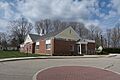
Marlborough Town Hall
-
Seal of Marlborough, Connecticut
-
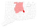
Marlborough's location within Hartford County and Connecticut
-
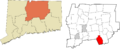
Marlborough's location within the Capitol Planning Region and the state of Connecticut
See also
 In Spanish: Marlborough (Connecticut) para niños
