Willimantic River facts for kids
Quick facts for kids Willimantic River |
|
|---|---|

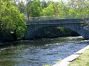
The Willimantic River flows past the old American Thread Company mill in Willimantic, CT.
|
|
| Country | United States |
| State | Connecticut |
| Counties | Tolland, Windham |
| Physical characteristics | |
| Main source | Confluence of Middle River and Furnace Brook Stafford Springs, Tolland County, Connecticut, United States 41°57′09″N 72°18′07″W / 41.95250°N 72.30194°W |
| River mouth | Confluence with Natchaug River to form Shetucket River Willimantic, Windham County, Connecticut, United States 41°42′46″N 72°11′30″W / 41.71278°N 72.19167°W |
| Length | 25 mi (40 km) |
| Basin features | |
| Basin size | 225 sq mi (580 km2) |
The Willimantic River is a river in northeastern Connecticut, United States. It flows for about 25 miles (40 km). This river is a tributary, which means it flows into a larger river. The Willimantic River joins the Natchaug River to form the Shetucket River.
The river starts in northern Tolland County, near Stafford Springs. It forms where two smaller streams, Middle River and Furnace Brook, meet. The Willimantic River then flows south. It passes through towns like Coventry, Columbia, and Windham.
Contents
What Does the Name Willimantic Mean?
The name Willimantic comes from an old Native American language. It's from either the Mohegan-Pequot or Narragansett people. Many people think it means "land of the swift running water."
However, experts believe the name probably first meant "place near the evergreen swamp." The name has changed over time. It was first written as Waramanticut in 1684. Later, it became Wallamanticuk, Wewemantic, and Weammantuck before we got Willimantic.
Where Does the River Flow?
The Willimantic River flows through different types of land. Near where it meets the Natchaug River, the Willimantic River drops 90 feet in just one mile. This big drop in height made the river powerful.
This power was used by old factories called textile mills. These mills made cloth and other products. They were located all along the river, from Stafford Springs to the city of Willimantic. One famous mill was the American Thread Company mill. Today, none of these mills are still making textiles. Many have been changed into apartments or other buildings.
Exploring the River by Boat
The Willimantic River is a popular spot for paddling. You can start a long boat trip south of Stafford Springs, near Route 32. In this area, the river moves quickly.
Further downstream, the river becomes calmer as it reaches Eagleville Pond. The rest of the trip to Route 66 is usually easy. Be careful of a dam near the Route 275 bridge. There are many other places where you can get into the river. These include bridges at N. River Road, Route 74, Depot Road, Route 195, Jones Crossing, Merrow Road, U.S. Route 44, Brigham, Route 31, and Flanders Road.
Bridges Over the Willimantic River
Many bridges cross the Willimantic River. These bridges connect different towns and allow cars, trains, and people to cross. Here are some of the crossings:
| County | Town | What Crosses |
|---|---|---|
| Windham | Windham | |
| Closed Bridge | ||
| The Garden
Bridge |
||
| South St.
(Frog Bridge) |
||
Railroad |
||
| Willimantic Footbridge | ||
| Windham/Tolland | Windham/Columbia | |
| Windham/Coventry | (Willimantic Bypass) |
|
| Tolland | Mansfield/ | Flanders Rd. |
Railroad |
||
| Depot Rd. | ||
Railroad |
||
| Plains Rd. | ||
| Merrow Rd. | ||
| Mansfield/ | ||
| Willington/ | Railroad (Twice in a row) |
|
| S. River Rd./Depot Rd. | ||
Railroad |
||
| Ellington/ | Railroad |
|
| Stafford |
 | Chris Smalls |
 | Fred Hampton |
 | Ralph Abernathy |

