Columbia, Connecticut facts for kids
Quick facts for kids
Columbia, Connecticut
|
||
|---|---|---|
| Town of Columbia | ||

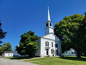
Columbia Congregational Church
|
||
|
||
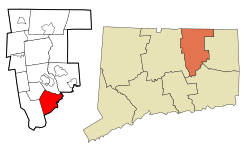
 Tolland County and Connecticut Tolland County and Connecticut |
||
| Country | ||
| U.S. state | ||
| County | Tolland | |
| Region | Capitol Region | |
| Incorporated | 1804 | |
| Government | ||
| • Type | Selectman-town meeting | |
| Area | ||
| • Total | 22.0 sq mi (57.0 km2) | |
| • Land | 21.4 sq mi (55.3 km2) | |
| • Water | 0.6 sq mi (1.6 km2) | |
| Elevation | 551 ft (168 m) | |
| Population
(2020)
|
||
| • Total | 5,272 | |
| • Density | 246.4/sq mi (95.3/km2) | |
| Time zone | UTC−5 (EST) | |
| • Summer (DST) | UTC−4 (EDT) | |
| ZIP Code |
06237
|
|
| Area code(s) | 860/959 | |
| FIPS code | 09-16400 | |
| GNIS feature ID | 0213411 | |
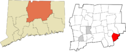
Columbia is a small town located in the Capitol Planning Region of Connecticut, United States. In 2020, about 5,272 people lived there.
Columbia was once part of a larger town called Lebanon. It was known as the North Society or Lebanon's Crank. In May 1804, Columbia officially became its own town. It was named "Columbia" to show love for the United States, as Columbia is an old patriotic symbol for the country.
For school, students in Columbia attend Horace W. Porter School from pre-kindergarten up to eighth grade. After that, high school students can choose to go to one of four nearby high schools: E. O. Smith High School, Bolton High School, Coventry High School, or Windham Technical High School.
Contents
Geography of Columbia
Columbia covers a total area of about 22.0 square miles (57.0 square kilometers). Most of this area, about 21.4 square miles (55.3 square kilometers), is land. The rest, about 0.6 square miles (1.6 square kilometers), is water.
Population Changes Over Time
| Historical population | |||
|---|---|---|---|
| Census | Pop. | %± | |
| 1850 | 876 | — | |
| 1860 | 832 | −5.0% | |
| 1870 | 891 | 7.1% | |
| 1880 | 757 | −15.0% | |
| 1890 | 740 | −2.2% | |
| 1900 | 655 | −11.5% | |
| 1910 | 646 | −1.4% | |
| 1920 | 706 | 9.3% | |
| 1930 | 648 | −8.2% | |
| 1940 | 853 | 31.6% | |
| 1950 | 1,327 | 55.6% | |
| 1960 | 2,163 | 63.0% | |
| 1970 | 3,129 | 44.7% | |
| 1980 | 3,386 | 8.2% | |
| 1990 | 4,510 | 33.2% | |
| 2000 | 4,971 | 10.2% | |
| 2010 | 5,485 | 10.3% | |
| 2020 | 5,272 | −3.9% | |
| U.S. Decennial Census | |||
In 2020, there were 5,272 people living in Columbia. There were also an estimated 2,161 homes.
Most people in Columbia are White (90.1%). Other groups include African American (1.9%), Native American (0.3%), and people of two or more races (5.6%). About 5.4% of the population is Hispanic or Latino.
In 2000, about 36.2% of homes had children under 18 living there. The average household had 2.65 people, and the average family had 3.01 people.
The population of Columbia is spread out by age. About 26.2% of residents are under 18. About 10.9% are 65 years old or older. The average age in town is 40 years.
Historic Places in Columbia
Columbia has a special area listed on the National Register of Historic Places. This is the Columbia Green Historic District. It helps protect important old buildings and places.
Famous People from Columbia
- Anthony Gregorc: A well-known psychologist who lives in Columbia.
- Dwight Loomis (1821–1903): He was a US Congressman and later a judge on the Connecticut Supreme Court.
- Alfred Wright (1788–1853): Born in Columbia, he was a doctor and a Presbyterian missionary. He worked with the Choctaw Nation, translating texts and founding a school called Wheelock Seminary.
- Eleazar Wheelock (1711-1779): An important educator who founded Dartmouth College.
See also
 In Spanish: Columbia (Connecticut) para niños
 | George Robert Carruthers |
 | Patricia Bath |
 | Jan Ernst Matzeliger |
 | Alexander Miles |


