Tolland County, Connecticut facts for kids
Quick facts for kids
Tolland County
|
|
|---|---|

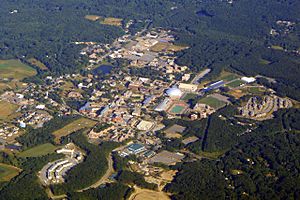
The University of Connecticut's main campus, in Storrs.
|
|

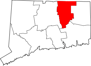
Location within the U.S. state of Connecticut
|
|
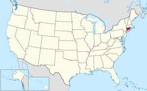
 Connecticut's location within the U.S. |
|
| Country | |
| State | |
| Founded | 1785 |
| Named for | Tolland, Somerset |
| Seat | none (since 1960) Tolland (1785-1889) Rockville (1889-1960) |
| Largest town | Vernon |
| Area | |
| • Total | 417 sq mi (1,080 km2) |
| • Land | 410 sq mi (1,100 km2) |
| • Water | 6.8 sq mi (18 km2) 1.6%% |
| Population
(2020)
|
|
| • Total | 149,788 |
| • Density | 359.2/sq mi (138.7/km2) |
| Time zone | UTC−5 (Eastern) |
| • Summer (DST) | UTC−4 (EDT) |
| Congressional district | 2nd |
Tolland County (/ˈtɑːlənd/ TAH-lənd) is a region in the northeastern part of Connecticut, a state in the United States. As of 2020, about 149,788 people live here. This area is made up of 13 towns. It was first created on October 13, 1785. It was formed from parts of Hartford County and Windham County.
Tolland County is part of a larger area called the Hartford-East Hartford-Middletown Metropolitan Statistical Area. This means it's connected to the bigger cities nearby for things like jobs and services.
In Connecticut, counties like Tolland County do not have their own governments. All the important decisions are made by the state, city, and town governments. The old job of High Sheriff in Connecticut counties ended in 2000. Now, state marshals handle court services and corrections. Tolland County has the same borders as the Tolland Judicial District. In 2022, the U.S. Census Bureau started to see Connecticut's nine "councils of governments" as the new county equivalents. This is because Connecticut's county governments were stopped in 1960. The councils of governments now handle some local government tasks. The eight historic counties of Connecticut still exist in name, but they are not used for official statistics anymore.
Contents
Geography of Tolland County
Tolland County covers a total area of about 417 square miles (1,080 km²). Most of this area, about 410 square miles (1,060 km²), is land. The rest, about 6.8 square miles (18 km²), is water. It is the second-smallest county in Connecticut by land area. It is the smallest by total area.
Neighboring Counties
Tolland County shares its borders with several other counties:
- Hartford County is to the west.
- New London County is to the south.
- Windham County is to the east.
- Hampden County, Massachusetts is to the northwest.
- Worcester County, Massachusetts is to the northeast.
Population and People
The number of people living in Tolland County has changed a lot over the years.
- In 1790, there were 13,251 people.
- By 1950, the population grew to 44,709.
- In 2010, it reached 152,691 people.
- In 2020, the population was 149,788.
2010 Census Information
According to the 2010 census, there were 152,691 people living in Tolland County. There were 54,477 households, which are groups of people living together. The average number of people in a household was 2.5. The average family had 3.0 people. The average age of people in the county was 38.3 years old.
Most people in Tolland County in 2010 were white (89.8%). Other groups included Asian (3.4%), Black or African American (3.3%), and American Indian (0.2%). About 4.3% of the population was of Hispanic or Latino origin. Many people had European roots. For example, 22.0% were Irish, 16.8% were Italian, and 14.3% were English.
The average income for a household in the county was $77,175. For families, the average income was $91,631. About 6.4% of all people in the county lived below the poverty line. This included 5.2% of those under 18 years old.
Towns and Communities
Tolland County is made up of several towns and smaller communities.
Main Towns
Other Local Areas
- Amston
- Coventry Lake
- Crystal Lake
- Gilead
- Hebron Center
- Hydeville
- Mashapaug
- Mansfield Center
- Rockville
- Somers center
- South Coventry
- Stafford Hollow
- Stafford Springs
- Storrs
See also
 In Spanish: Condado de Tolland para niños
 | Tommie Smith |
 | Simone Manuel |
 | Shani Davis |
 | Simone Biles |
 | Alice Coachman |


